How to Navigate in the Steppe: Orientation Methods Without a Compass
 libre
libre
To navigate the steppe without landmarks, read the natural signs around you: the position of the Sun, Moon, and stars, the orientation of "compass" plants like lettuce and sunflower, the shape of gullies and animal burrows, and — for modern travellers — a compass, map, and GPS device. The open grassland of the Eurasian steppe offers no milestones or posts, but it is full of reliable directional clues once you know how to interpret them.
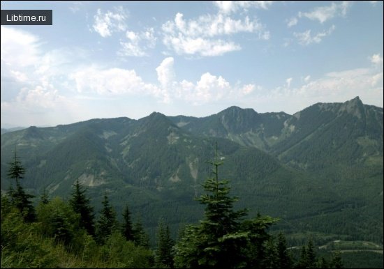
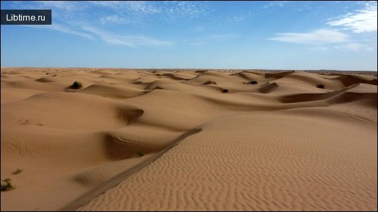
A wide, boundless plain spreads out before the traveller. As far as the eye can see, there is a space covered with a motley carpet of all kinds of flowers and grey sagebrush. Above the head there is a deep, transparent sky. It seems the eye has nothing to stop on — no milestone, no post, no bush. How do you keep a direction, avoid losing your way, and not "spin" in the steppe?

How to Navigate in the Steppe: Finding Direction Without Landmarks
Navigating the steppe relies on a layered system of natural cues rather than a single tool. Experienced steppe travellers cross-check several signs at once: the Sun's arc through the day, the Moon and constellations at night, the orientation of certain plants, the asymmetry of gullies, and the habits of burrowing animals. Combining two or three of these is far more reliable than trusting any one alone, because a single clue can mislead under unusual weather or terrain.
Here is an excerpt from M. Belkina's story "A Case in the Steppe," which captures the disorientation the open plain can cause.
They got lost in the steppe. Zubakha seemed to get lost in the forest, in the mountains, in a large foreign city, but in the steppe, where you can see in all directions? In front of them to the right and to the left, wherever you turn, the steppe. All around is steppe....,
They wandered for a long time, having already realised that they had lost their way; they drove to the west, to the east, came back, drove the car forward — the steppe was moving behind them. It closed them in its circle and did not let them out, did not let them escape, and everywhere, wherever they turned, they were in the centre of this enchanted circle, outlined by the horizon.
- The steppe was spinning!
Zubakha remembered a phrase he had once heard.
-Yes, circled! Twirled and twirled until all the gasoline was gone! Till the truck was completely dead!
Why It's Easy to Get Lost in the Steppe
Disorientation in the steppe happens because the eye finds nothing fixed to anchor on, and the brain, lacking reference points, tends to steer a person in a slow, unconscious curve. This is the same drift that makes lost travellers walk in circles in deserts and snowfields. On the flat, repetitive grassland every direction looks identical, so without a deliberate method of holding a bearing, a traveller — or a vehicle, as in Belkina's story — gradually loops back on its own track.
There are landmarks in the steppe; you just have to look carefully. Among them: a small area covered with last year's blackened weeds, or a saline — an oddly shaped bald spot in the turf. A gopher's burrow will also help establish direction, since these rodents, as a rule, dig the entrance to their dwelling on the southern side.
 The most reliable references in the steppe zone are the Sun, the Moon, and the constellations, together with certain plants.
Understanding the Steppe Environment
The steppe is a vast belt of temperate grassland, and understanding its nature explains why its navigation cues exist at all. The plants behave as compasses because of heat and drought; the gullies differ slope to slope because of sun angle and snowmelt. Knowing the environment turns a featureless plain into a readable surface.
Definition and Characteristics of Steppes
A steppe is a flat or gently rolling plain dominated by grasses and herbs, with few or no trees. The world's largest example is the Eurasian steppe, a continuous grassland corridor running roughly from Hungary and the Danube River in the west, across the Kazakh steppe and the Mongolian Steppe, to the Greater Khingan range near China in the east. Comparable grasslands exist elsewhere: the Great Plains of North America — once home to vast herds of American bison — are the New World's equivalent of the steppe, bounded by the Rocky Mountains much as Eurasia's grasslands are framed by the Ural and Altai Mountains.
Steppe vegetation is built from drought-tolerant grasses, sagebrush, and herbs adapted to long dry spells. This grass carpet historically supported nomadic herding cultures across the Eurasian steppe, from the ancient Andronovo Culture and Pazyryk culture whose burials were excavated at sites like Berel, to the Kazakhs and Mongols of today. The same open terrain became the great corridor of movement in history — the Steppe Route and later the Silk Road threaded trade in goods, metallurgy, and ideas across it, and Genghis Khan's cavalry exploited its grass to feed the horses of an empire stretching from Karakorum toward the Caspian Sea and the Danube.
Climate and Environmental Conditions
The steppe has a continental climate marked by hot, dry summers, cold winters, and low, unreliable rainfall. This moisture shortage is the key fact behind steppe navigation, because it forces plants to orient their growth to limit water loss — the very behaviour that turns them into living compasses. Precipitation falls mostly in late spring and early summer, while the rest of the year stays arid, which is why succulents and deep-rooted herbs dominate the flora.
These same conditions also threaten the grassland. Overcultivation, soil erosion, and the conversion of pasture to farmland have driven desertification across parts of the Kazakh steppe and Mongolia, undermining the nomadic lifestyle that depends on healthy grazing. Grassland conservation efforts now focus on limiting ploughing, controlling overgrazing, and protecting the migratory routes herders have followed for centuries.
Natural Landmarks for Orientation
The first level of steppe navigation is reading the ground itself — patches of vegetation, bare salines, and the shape of small landforms that record the direction of the prevailing sun and weather. These features cost nothing to read and remain visible even when the sky is overcast.
Reading the Terrain: Weeds, Salines, and Bald Spots
Distinct ground features serve as fixed reference points across an otherwise uniform plain. A patch of last year's blackened weeds, a pale saline crust, or an oddly shaped bald spot in the turf each marks a specific location you can steer toward and away from to hold a line. The trick is to pick such a feature ahead of you, walk or ride straight to it, then choose the next one beyond — stitching a straight course out of a chain of small landmarks.
Using Animal Burrows: The Gopher's Mink Method
Gopher and ground-squirrel burrows give a directional clue because these rodents typically place their entrances on the southern side of the mound, where the morning and midday sun warm and dry the opening. Checking several burrows in an area and noting the consistent orientation of their entrances lets you fix south, and from it the other cardinal points. As with all single clues, confirm the pattern across multiple burrows rather than trusting one, since a stray hole can sit at any angle.
Plant-Based Navigation: Natural Compasses of the Steppe
Several steppe plants align parts of themselves to the Sun and so act as natural compasses. They do this to survive drought — turning leaves edge-on to the harshest light, or tracking the Sun to maximise or limit exposure — and the side effect is a reliable directional signal a traveller can read.
Lettuce: The Steppe Compass
Wild lettuce is the classic compass plant of the dry steppe, found across the central and southern regions of the European plain, Western Siberia, and Central Asia. It is a biennial weed with baskets of yellow flowers and vertically arranged leaves that somewhat resemble dandelion leaves. In moist or shaded spots its leaves sit evenly on all sides of the stem, but in dry, open ground — its usual habitat — the leaf blades turn flat toward the west and east, presenting their edges, or ribs, to the north and south.
By turning its leaf edges toward the south, lettuce shields them from direct sunlight during the hottest part of the day and so reduces evaporation. Compared against a compass, the leaves point fairly accurately along the horizon — which is exactly why the plant earned the name "steppe compass." Lettuce growing in the open is therefore one of the steppe's most accessible direction-finders.
Sunflower as a Compass
The sunflower tracks the Sun through the day, making it a reliable orientation aid.

Once the seeds ripen, sunflower heads settle in roughly one direction — east or southeast, more rarely south, and never facing north. This means a field of mature sunflowers reveals the sides of the horizon at a glance, even under overcast skies, making the sunflower an excellent assistant in orienteering.
Sugar Beet as a Compass
Sugar beet roots grow along consistent compass directions, so they too can serve as an emergency direction-finder.

Studying the sugar beet variety "Verkhnyachka," scientists found that its white roots grow from east to west, while its red roots grow from north to south. The roots hold strictly to this direction and do not detour around obstacles, even where free soil lies nearby in another direction. When no other reference is available, you can dig up a beet and read the sides of the horizon from the orientation of its root.
Celestial Navigation in the Steppe
The sky is the steppe traveller's most dependable compass, used for thousands of years across the Eurasian steppe. Nomadic peoples developed sophisticated folk astronomy precisely because the open horizon gives an unobstructed view of the Sun, Moon, and stars from rim to rim.
Navigating by the Sun
The Sun fixes direction by its predictable daily arc: it rises in the east, stands due south at local noon in the northern hemisphere, and sets in the west. Tracking the shadow of an upright stick — shortest at midday, pointing north at that moment — gives a quick fix, and combining the Sun's position with the time of day lets you hold a steady bearing for hours. Because the Sun's azimuth shifts through the seasons, experienced travellers adjust for the time of year rather than assuming a fixed sunrise point.
Navigating by the Moon
The Moon extends solar navigation into the night, since its lit face and motion across the sky follow learnable rules. A waxing crescent or half-moon is highest in the south in the early evening and sets in the west, while a waning Moon rises in the east and stands south toward dawn — so noting the Moon's phase together with its position yields an approximate bearing. The Moon is most useful as a coarse check on a direction already estimated from other cues.
Navigating by Stars and Constellations
The stars are the steppe's oldest and steadiest guide, and across Kazakh culture an entire tradition of star reading grew up around them. The North Star marks true north almost exactly, and it can be found by following the two pointer stars at the end of the Big Dipper. Among the Kazakhs, specialist star readers known as zhuldy namashy — folk astronomers such as those described by researchers like Akhmet Toktabay and Khasen Abishev — used named stars and planets, the Pleiades among them, both to navigate and to time the seasonal migrations of livestock. In this way astronomy on the steppe served not only orientation but economic planning, linking the night sky to the calendar of herding and weather forecasting.
Gullies and Sinkholes as Directional Clues
The asymmetry of gullies and ravines is a quieter but reliable steppe compass, because sun and snowmelt shape opposite slopes differently.

One slope was gentle and, like velvet, covered with soft green grass — the southern slope. The opposite slope was steeper, bare, with sandy screes only occasionally covered with faded vegetation — the northern slope. The difference is created by sun exposure: in a west–east ravine the south-facing slope catches gentle, sliding rays and keeps its grass, while the shaded, colder slope erodes.
The northern slope frees itself from snow more quickly, and under sharp temperature swings — thawing by day, freezing by night — many cracks form in its ground. It dries earlier and is readily destroyed by rain and meltwater pouring into the ravine. On the southern slope, snow lingers longer in spring, water seeps gradually into the soil rather than rushing to the bottom, and in summer the Sun's rays slide across the surface and scorch the grass less. The same pattern recurs in other gullies, and ravines running north–south usually show matching slopes on both sides.
Gullies aligned southwest to northeast or northwest to southeast are harder to read, since their slopes look almost identical. Even so, with practice and careful observation it is possible to determine the sides of the horizon without a compass.
Modern Navigation Tools and Equipment
Modern travellers crossing the steppe pair traditional cues with a compass, paper map, and GPS device, which together remove most of the risk of getting lost. Adventurers such as Tim Cope, who rode from Mongolia to Hungary on the trail of Genghis Khan, and writers like Alastair Humphreys have shown that the old skills and new tools work best in combination — the technology fails, the batteries die, and the natural signs fill the gap.
Using a Compass and Map
A magnetic compass plus a topographic map remains the most failure-proof navigation method on the steppe, because neither needs power or signal. The compass gives a constant bearing to counter the unconscious drift that makes people circle, while the map ties that bearing to terrain features, water sources, and settlements. Carrying both as a backup to any electronic device is standard practice for serious steppe expeditions.
GPS and Digital Navigation Devices
A smartphone or dedicated GPS unit can pinpoint your position on the steppe even with no mobile signal, provided you prepare it in advance. The key is offline data: several apps store maps and routes locally so they work far from any network. Useful options for remote Mongolia and the Kazakh steppe include:
- Google Maps Offline — download map areas before you set out; GPS positioning still functions without internet.
- Maps.me — detailed offline maps with tracks and trails, popular with overland travellers for its coverage of minor routes.
- Komoot — route planning for cycling, hiking, and riding, with offline maps and turn cues once a region is downloaded.
- Google Earth — plan and visualise a route ahead of time, then export it for use in the field.
- Google Translate offline — not navigation, but invaluable for asking nomadic families for directions when village names on maps are inconsistent or spelled differently than locals say them.
Smartphone GPS works without internet because the location chip reads satellite signals directly; only the map tiles need to be downloaded beforehand. Travellers frequently note on forums such as Reddit that village names in remote Mongolia vary between maps and signposts, so cross-checking GPS coordinates against a paper map and local knowledge prevents costly detours to nonexistent or misnamed settlements.
Charging Devices While Traveling
Keeping devices charged on a multi-day steppe journey depends on carrying your own power, since petrol stations and electricity are scarce between towns. Practical solutions include a folding solar panel strapped to a pack or saddlebag, a high-capacity power bank charged whenever you reach a ger camp or settlement, and — for those travelling by motorbike or vehicle — a USB charger wired to the engine. Because daylight is abundant on the open steppe, solar charging is especially effective in the long summer days.
Practical Tips to Avoid Getting Lost
Avoiding disorientation on the steppe comes down to fixing a bearing and constantly verifying it against the land and sky. The methods below turn the scattered natural and technological cues into a steady, repeatable routine.
Maintaining a Straight Direction Across Open Plains
Hold a straight line by aiming at a distant point and replacing it as you go, rather than trying to walk "straight" by feel. Choose any visible feature on your bearing — a saline patch, a rise, a clump of dark weeds — and head for it; when you reach it, sight the next feature beyond on the same line. On truly featureless ground, line up two markers behind you and keep them aligned by looking back, or check your shadow and the Sun at regular intervals. This back-and-forward sighting cancels the natural tendency to curve.
What to Do If You Lose Your Way
If you realise you are lost, stop moving before you waste energy or fuel circling, exactly as the truck did in Belkina's story. Then work the problem methodically:
- Stay put and calm; panic drives the aimless looping that strands travellers.
- Establish direction from the Sun, stars, a compass, or a GPS fix before taking another step.
- Check any offline map or saved route against your surroundings.
- If near a water source, road, or fence line, follow it — linear features lead to people.
- Look for a ger or herders; nomadic families on the steppe are famously hospitable and will point the way, food and shelter often included.
Best Time and Conditions for Steppe Travel
The best time to cross the Mongolian or Kazakh steppe is summer through early autumn, roughly June to September, when the grass is green, rivers are passable, and nights are mild. This window also coincides with the great cultural events: the Naadam Festival in Mongolia in July, with its horse racing, wrestling, and archery, and the Golden Eagle festivals of the Kazakh eagle hunters in Bayan-Ölgii in autumn. Spring travel is possible but unpredictable, with sudden cold snaps, mud, and swollen rivers, while winter brings extreme cold and ice festivals but demands serious survival preparation. Travelling slightly off-peak — late August or September — gives quieter routes and lower expedition costs while keeping the weather workable.
Equipment and Gear for Long-Distance Steppe Journeys
A long steppe expedition — on horseback, by bicycle, or by motorbike — needs gear chosen for self-sufficiency over hundreds of kilometres between supplies. Whatever the mode of travel, the open grassland means carrying your own water capacity, shelter, navigation tools, and the means to keep them powered. Core items include:
- Navigation: compass, paper map, and a GPS device or smartphone loaded with offline maps and a planned route.
- Power: solar panel and power bank to charge devices where electricity is absent.
- Shelter and warmth: a four-season tent or the option of ger camps, plus warm layers for cold nights even in summer; local traditional dress such as the Mongolian deel is remarkably suited to the climate.
- Water and food: ample carrying capacity and a plan for restocking at the sparse food shops and petrol stations between towns.
- For riders: a sound horse, tack suited to long days in the saddle, and basic veterinary supplies.
- For cyclists and motorcyclists: spares and repair tools, and — for motorbikes — enough fuel range to cover the long gaps between petrol stations.
Beyond the equipment, the steppe rewards respect for its people and its grasslands: travel with local guides where possible, support responsible and sustainable tourism, ask permission near herders' camps, and leave the fragile grass cover undamaged. The same open plain that once baffled lost travellers becomes navigable, and deeply rewarding, to anyone who learns to read its signs.