Orienteering on the Terrain: How to Find Directions Without a Compass
 libre
libre
Orienteering is the skill and sport of finding your way across unfamiliar terrain using a map, a compass, or natural signs to determine the sides of the horizon and your own position relative to them. In everyday hiking it means knowing where north, south, east and west lie even in cloudy weather without instruments; as a competitive sport it means navigating between fixed control points on a detailed map as fast as possible. This page covers both senses — the practical bushcraft of reading nature and the international sport governed by the International Orienteering Federation.
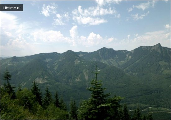
Hundreds of thousands of travellers set out hiking in every season, in their native lands and abroad, and many take part in tourist meets and competitions. Travellers can be seen in the Carpathians, in the forests around large cities, on the mountain trails of distant ranges and in countless other regions of the world. Crossing a turbulent river, a night fire and sleeping under the open sky attract people with their romance.

What Is Orienteering on the Terrain?
Orienteering on the terrain is the act of determining the cardinal directions and your location relative to them, then choosing a route toward a goal. It is not easy to find a ford across a rough river, read the tracks of animals, or work out where north and south lie without a compass in cloudy weather — yet all of these depend on the same core skill of orientation. Instruments such as radio beacons, radio compasses and mechanical wayfinders exist for this purpose, but a hiker rarely carries them; a compass, a map, or the simplest sketch of the terrain is usually enough.
As a recreational activity, orienteering doubles as healthy exercise: it combines sustained walking or running with constant problem-solving, keeping both body and mind engaged. As a competitive sport, orienteering adds a clock, a precisely surveyed map and a sequence of control points that must be visited in order, turning navigation into a race.
Why Terrain Orientation Skills Matter
Terrain orientation skills matter because they keep travellers safe and self-reliant when technology fails or was never available. A person who knows nature well freely "reads" the writing that stays closed to the inexperienced eye, using the sun, wind, stars and living signs as guides. The ability to navigate on the terrain is a dependable assistant in competitions and hiking trips alike — and for those who later choose a profession as a "person of the first trail," it becomes a daily working tool.
Who Needs to Orient on the Terrain
Orientation skills are needed by far more than weekend hikers. People in many professions can find themselves in unforeseen conditions where instruments are lost or unusable, including:
- Surveyors and topographers mapping remote ground;
- Geologists and botanists working off established trails;
- Foresters and gamekeepers patrolling large tracts of woodland;
- Hunters following game far from roads;
- Soldiers operating away from marked routes;
- Competitive orienteers, adventure racers and youth groups in training.
Real-Life Examples of Navigating Without Instruments
Real navigation without instruments has saved lives, as the classic account of pilot Alexei Maresiev in B. Polevoy's "The Story of a Real Man" shows. Shot down in dense forest some fifty kilometres from the front line without map or compass, Maresiev knew which way to crawl because he could orient himself by the sun. He was also helped by the wind, which "pulled from the east" and carried to him the clearly distinguishable sounds of cannonade. Many more such examples can be given of people who found direction on the ground using nothing but their reading of nature.
Determining the Sides of the Horizon
You can determine the sides of the horizon — north, south, east and west — without any instrument by reading the sun, the wind, the night sky and natural indicators on plants and ground. Each method gives an approximate bearing on its own, but combining several of them produces a reliable result. The sections below cover the four most practical natural references.
Orienteering by the Sun
The sun is the most reliable natural reference because its path across the sky is predictable. In the Northern Hemisphere the sun rises in the east, stands due south around local noon, and sets in the west; at noon a vertical object casts its shortest shadow pointing roughly north. With an analogue watch held flat, point the hour hand at the sun and the line bisecting the angle between the hour hand and the 12 marks the north–south line. On a clear day this method fixes direction within a few degrees.
Orienteering by the Wind
The wind helps with direction when its prevailing course for a region or a day is known, as it did for Maresiev. Before relying on the wind, note its steady direction at a landmark — by watching smoke, drifting cloud or bending grass — and keep that reference as you travel. Wind alone is never precise because gusts shift, so it is best used to confirm a bearing already taken from the sun or to hold a rough course between checks.
Orienteering by Stars at Night
At night the stars give direction, and in the Northern Hemisphere Polaris, the North Star, marks true north almost exactly. Find Polaris by following the two "pointer" stars at the end of the bowl of the Big Dipper (Ursa Major) about five times their separation; the star they point to barely moves through the night, so facing it means facing north. South of the equator there is no equivalent pole star, and navigators use the Southern Cross to estimate south instead.
Natural Signs and Indicators in Nature
Plants, snow and terrain features offer supporting clues to direction when sun and stars are hidden. Useful natural indicators include:
- Tree crowns and foliage often growing fuller on the warmer, sunnier southern side;
- Moss and lichen tending to be more abundant on the cooler, damper northern side of trunks and stones;
- Snow melting faster on south-facing slopes;
- Annual rings on a cut stump sometimes wider on the southern side;
- Anthills frequently built against the southern side of a tree or stone.
Each sign is only a hint and can be misleading on its own, so cross-check several before trusting the result.
Orienteering by Compass
A compass is the most dependable tool for terrain orientation because its needle settles on magnetic north regardless of weather, time of day or visible landmarks. Orienteering by compass has its own nuances, covered in a separate article, but the core principle is to align the compass with a map, account for the difference between magnetic and true north, and take a bearing to your objective. Combined with terrain reading, the compass turns rough natural estimates into a precise, repeatable heading.
Using Maps and Terrain Schemes
A map or a simple hand-drawn terrain scheme lets you relate the compass bearing to real features on the ground. To use them together, orient the map so its north matches the compass needle, identify your position against visible landmarks, then plan a route along handrails such as streams, ridges and paths. Even a rough sketch showing the relative positions of a river, a road and a hill is enough to keep a hiker oriented when no printed map exists.
Modern Navigation Devices and Tools
Modern devices add precision and backup to traditional navigation but never fully replace map-and-compass skill. GPS receivers and smartphone apps display your position on a digital map, and tools like MapRun use a phone's GPS to register control points without physical equipment. Batteries die and signals drop in deep terrain, however, so experienced navigators treat electronics as a complement to a compass, not a substitute.
Orienteering as a Competitive Sport
As a competitive sport, orienteering challenges participants to visit a series of control points marked on a special map in the correct order and in the shortest time. The sport originated in Sweden in the late nineteenth century — the first recorded competition took place in 1886, and early events grew from military training at institutions such as the Military Academy Karlberg — before spreading from Sweden to Norway and worldwide. Today it is governed internationally by the International Orienteering Federation (IOF), with national bodies including British Orienteering Federation, the Scottish Orienteering Association, and Orienteering USA (also known as USA Orienteering) overseeing the sport in their countries.
The pinnacle events draw large fields and elite athletes: the World Orienteering Championships crown world titles, orienteering features in the World Games, and Swiss star Simone Niggli-Luder and French champion Thierry Gueorgiou rank among the most decorated competitors the sport has produced.
Course Design and Control Points
An orienteering course is a planned sequence of control points, each placed at a distinct terrain feature such as a boulder, a stream junction or a depression. Course designers select features that test navigation rather than luck, link them so route choice matters, and mark the start, the controls and the finish on the map. The runner must visit the controls in the set order on a point-to-point course, proving each visit by punching at the marker.
Control Descriptions and Checkpoint Markings
Each control is identified on the ground by an orange-and-white three-sided flag and on paper by a control description that pinpoints exactly what feature it sits on. Control descriptions use internationally standardised symbols (so they work across languages) together with a code number that the competitor checks against the marker to confirm it is the right control. Out-of-bounds areas and natural hazards are also marked on the map so runners avoid sensitive ground and danger.
Competition Rules and Scoring Systems
Orienteering scoring depends on the format, but the two main systems are point-to-point timing and score events. On a standard course the fastest correct completion wins, with split times recorded at each control. Score and rogaining formats instead award points for controls reached within a fixed time limit, rewarding strategy over a set route. Common rules across formats include:
- Controls must be visited in the prescribed order on point-to-point courses;
- Each control must be punched to count;
- Missing or mis-punching a control means disqualification;
- Out-of-bounds areas must not be entered.
Course Difficulty and Classifications by Age and Ability
Courses are graded by difficulty and offered in age and ability classes so newcomers and elites can compete fairly on the same day. Difficulty progresses from beginner to advanced:
- Beginner courses follow paths and obvious features over short distances, often completed in 20–40 minutes;
- Intermediate courses leave the trails and require basic compass work and route choice;
- Advanced courses demand precise navigation across complex terrain, with winning times of 30–90 minutes depending on the discipline.
Age-based classes run from young juniors to veterans, letting a family enter the same event at appropriate challenge levels.
Electronic Timing and Punching Systems
Electronic punching has replaced paper-and-pin cards at most modern events, recording both attendance and split times automatically. Systems such as SportIdent and EMIT use a small finger-stick or card that the runner inserts into each control unit, which logs the exact time of the visit. At the finish the data downloads instantly to produce full results with split times, letting competitors see precisely where they gained or lost time against rivals.
Equipment and Technology Used in Orienteering
Orienteering needs surprisingly little equipment, which is part of its appeal as recreational exercise. The essentials are:
- A detailed orienteering map specific to the area;
- A baseplate or thumb compass;
- An electronic timing stick (SportIdent or EMIT) at organised events;
- A control description holder, often worn on the wrist;
- Sturdy off-trail footwear and weather-appropriate clothing.
Many state parks run compass loaner programs so beginners can borrow a compass on arrival, and permanent courses let people practise with nothing more than a printed map and a phone app such as MapRun.
Disciplines and Variations
Orienteering covers a family of disciplines that share map-and-compass navigation but vary the means of travel and the setting. The major variations include foot orienteering (FootO), mountain bike orienteering, ski orienteering (Ski-O), trail orienteering, night orienteering, and urban or park orienteering held in towns and green spaces. Related navigation sports such as adventure racing, rogaining and amateur radio direction finding extend the same skills into new formats.
Classic Course Style
The classic style is point-to-point foot orienteering, run in sprint, middle and long distance variants. Sprint courses are fast and short, typically 12–15 minutes of running in parks or urban terrain; middle distance emphasises technical navigation over roughly 25–35 minutes; and long distance tests endurance and route choice across 70–100 minutes. Relay orienteering adds a team element, with members running successive legs — the Swedish Tiomila and Finnish Jukola relay are the largest relays in the world, and O-Ringen is the biggest multi-day foot event.
Adventure Racing and Mountain Bike Orienteering
Adventure racing and mountain bike orienteering apply navigation over longer distances and faster travel. Mountain bike orienteering keeps riders on a network of tracks where the key skill is choosing the quickest legal route at speed, while adventure racing combines navigation with trekking, paddling and cycling over many hours or days. Ski orienteering carries the same idea onto a network of prepared trails using Ski-O and Nordic skiing maps, where route choice among the tracks is decisive.
Amateur Radio Direction Finding
Amateur radio direction finding (ARDF), also called radio orienteering or foxhunting, replaces visual controls with hidden radio transmitters. Competitors carry a receiver and a directional antenna, take bearings on each "fox" as it transmits, and navigate to it using a map and compass exactly as in foot orienteering. ARDF combines radio skill with terrain navigation and is governed under the same IOF umbrella as the other disciplines.
Maps and Cartography for Orienteering
Orienteering maps are far more detailed than general topographic maps and follow strict international specifications for scale, symbols and colour. Standard scales are 1:15,000 or 1:10,000 for forest courses and 1:4,000 or 1:5,000 for sprints, with a five-colour standard: black for rock and man-made features, brown for landforms, blue for water, yellow for open land and white for runnable forest. This is why Ordnance Survey maps are unsuitable for the sport — they lack the fine vegetation, runnability and small-feature detail that orienteers need, and an Ordnance Survey sheet cannot show whether a patch of forest is fast or thick.
Custom Map Creation Services
Custom orienteering maps are surveyed and drawn specifically for each venue using specialist cartography software. Mappers build base data in GIS tools such as QGIS, then draft the final map in dedicated orienteering software like OCAD, walking the ground to record every boulder, path and vegetation boundary. Specialist providers such as Wild Terrain Navigation produce maps for clubs and parks, and organisations like the Delaware Valley Orienteering Association, the Western Pennsylvania Orienteering Club and Grizzly Orienteering maintain mapping portfolios across many state parks.
Drone Imagery and Aerial Surveying
Modern mapping increasingly starts from LiDAR and drone imagery before any fieldwork begins. LiDAR data is processed into digital elevation models (DEM) that reveal contours, depressions and earthworks with great precision, while drone photography captures up-to-date aerial imagery and GPS field surveying ties the detail to accurate coordinates. These basemaps cut survey time and improve accuracy, after which the cartographer verifies and refines everything on the ground.
Environmental Protection and Conservation
Orienteering depends on healthy natural areas, so environmental protection is built into how events are planned and run. Organisers coordinate with land managers to secure access agreements, route courses around sensitive ground, mark out-of-bounds areas on the map, and time events to avoid breeding and growing seasons. Responsible event management leaves the terrain as it was found and often improves the relationship between the sport and the landowners who host it.
Environmental Sensitivity Assessments
Before an event, organisers carry out environmental sensitivity assessments in consultation with conservation bodies. In the UK this means working with organisations such as the RSPB, Scottish Natural Heritage and the relevant statutory agencies to identify nesting sites, protected plants and fragile habitats, then placing controls and out-of-bounds boundaries accordingly. These assessments are a standard condition of land manager permissions and access agreements for large events.
Bio-Remediation and Native Habitat Projects
Some orienteering clubs give back to the land they use through bio-remediation and native habitat projects. These can include native tree planting, invasive-species removal, trail repair and community efforts such as fruit tree grafting workshops, turning event venues into long-term conservation partnerships. Such projects strengthen the case for continued access and demonstrate that recreational use and habitat restoration can work together.
Getting Started: Training and Community Workshops
The easiest way to start orienteering is to find a local club and attend a beginners' event, where maps, instruction and often a loaner compass are provided. Local clubs and national bodies run community training workshops covering map reading, compass use, land navigation and wilderness survival skills, progressing newcomers from path-following beginner courses to technical advanced ones. Permanent orienteering courses at state parks let people practise at any time, with course maps and navigation materials available from the park office or online.
Clubs also serve youth education: programs like the Youth Mapping Program teach schoolchildren to read and make maps, and seasonal club events — fixtures such as the Baird Creek Bumble near Green Bay and the Fall Fumble — give families an approachable introduction. Online communities, including orienteering discussions on Reddit, help newcomers find their nearest club and upcoming events.
Economic Benefits of Hosting Orienteering Events
Hosting orienteering events brings measurable economic benefits to the communities and parks that stage them. Multi-day events in particular attract visitors who stay, eat and shop locally for a week at a time:
- Major events such as O-Ringen in Sweden and the Scottish International 6-Day Orienteering Event draw thousands of competitors and their families;
- Visitors fill accommodation, restaurants and shops across the event week;
- State parks gain off-season visitor revenue and stronger community ties;
- Event sponsorship and partnership opportunities — including Orienteering USA Supporting Partner arrangements — bring funding to local clubs.
Beyond direct spending, well-run events raise the profile of host parks and encourage repeat recreational visits long after the competition ends.
Tips for Beginners on the Terrain
The best advice for a beginner on the terrain is to keep the map oriented, navigate from one obvious feature to the next, and always know roughly where you are. Practical starting tips include:
- Orient the map to north every time you change direction;
- Follow handrails — paths, streams, fences and ridgelines — rather than cutting blindly across country;
- Use catching features behind your target so you know when you have gone too far;
- Cross-check natural signs such as the sun and moss against your compass;
- Start on beginner courses and add difficulty only as your confidence grows;
- Carry water, suitable footwear and a whistle, and tell someone your planned route.
By studying nature's guides and pairing them with map and compass, you can become an active helper in the protection of crops and nature, and the ability to navigate on the terrain will be a dependable assistant in competitions, hiking trips and any future work on the first trail.