Underground Landscapes and Cave Morphology: Exploring Karst Caves and Natural Complexes
 libre
libre
Underground landscapes are complete natural complexes that develop inside the Earth's crust, bounded by the natural walls of cavities and caves, and shaped by the same morphological, climatic, hydrological, and biogeographical forces that build landscapes on the surface. Caves are the most studied of these subterranean landscapes, described by geographers such as Semenov-Tyan-Shansky (1928), Gvozdetsky (1954), and Gergedava (1968, 1973) as special geographical complexes limited by the natural boundaries of underground cavities. This page covers how these landscapes form, the rock types they develop in, their climate and hydrology, the minerals and life they host, and how humans have used the underground for shelter, burial, agriculture, and architecture.
Underground Landscapes: Definition and Significance
An underground landscape is a natural complex enclosed within the Earth's crust whose components — rock, water, air, minerals, and living organisms — interact as an integrated system, just as forests, rivers, and soils interact on the surface. Caves are the classic example: special geographical underground landscapes developed in the crust and limited by the natural boundaries of underground cavities. The study of these landscapes belongs to karstology and speleology, fields that treat the underground not as empty space but as a structured environment with its own morphology, climate, and biology.
Connection Between Underground and Terrestrial Natural Complexes
Underground natural complexes are closely connected with terrestrial ones, exchanging mineral and organic substances continuously across the boundary between surface and subsurface. Karst water and air circulation in caves drive this exchange, carrying dissolved carbonates, carbon dioxide, organic debris, and microorganisms between the two realms. Studying underground landscapes and their individual components allows researchers to reconstruct the evolutionary history of modern natural complexes to the greatest possible depth, because the slow, sheltered conditions underground preserve records that surface erosion destroys.

Factors Shaping Underground Geographical Landscapes
The peculiarity of underground geographical landscapes is caused by a complex combination and interaction of morphological, climatic, hydrological, and biogeographical factors. Morphology sets the shape of the space, hydrology supplies and removes water, climate governs temperature and humidity, and biogeography fills the cavity with specialized life. Each factor depends on the others, so a change in one — a shift in water flow, for example — reshapes the whole landscape over geological time.
Cave Morphology
The components and character of an underground landscape are largely determined by the morphology of its cave, whose most characteristic feature is the alternation of relatively narrow, low passages with wide, high grottoes. The grottoes are usually confined to areas of greatest tectonic fracturing and to places where chemically pure karst rocks develop, and in some cases they reach enormous sizes. The floor area of the grotto of the Georgian Speleologists in Anakopi cave is 10,635 m², an indication of how large these voids can grow where the rock and the fractures favour dissolution.
Tectonic and Lithogenetic Fracturing of Rocks
Tectonic and lithogenetic fracturing of rocks largely determines the morphology of underground grottoes and their connecting passages, controlling both the shape of the cross-section and the planned arrangement of karst cavities. Water exploits these fractures preferentially, so the map of a cave often mirrors the underlying joint and fault systems. The link between the plan view of a cave and its fracture systems is particularly well illustrated by Optimistic, Ozernaya, Kryvchenskaya, Khudugunskaya, and many other caves, whose maze-like patterns trace intersecting fracture sets.
Influence of Lithology and Hydrological Conditions
Lithology and hydrological conditions strongly influence the peculiarity of underground forms, producing distinctive features such as organ pipes, bag-shaped passages, ellipse-shaped depressions, and carrs. The composition and purity of the bedrock decide how readily it dissolves, while the volume, pressure, and chemistry of the water decide where and how fast cavities enlarge. Together these controls explain why caves in the same region but different rock units can look entirely unlike one another.
Organ Pipes and Chimneys
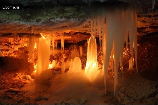
Organ pipes, also called chimneys, are vertical well-shaped cavities widened at the bottom and narrowed at the top, usually formed as upward extensions of ponors at the base of surface sinkholes. Their diameter ranges from 0.2 to 6 m and more, they are almost always underlain by earth shoals, and in some caves they cut clean through the roof so that daylight penetrates the passage below. Organ pipes are especially widespread in the Kungur Ice Cave, where 31 of them have been counted.

Ellipse-Shaped Depressions and Mixing Corrosion
Ellipse-shaped depressions on cave ceilings form where underground streams meet water arriving from above, through a process known as mixing corrosion. On their rounded inner surface a crack is always visible whose direction coincides with the long axis of the ellipse. The essence of mixing corrosion was first explained by Soviet researchers A. N. Buneev and F. F. Laptev, who proved that groundwaters containing carbon dioxide become sharply more aggressive when mixed. This process is important for developing deep karst forms at intersections of tectonic and lithogenetic fractures, and it generates peculiar elliptical passages, bag-like passages, and corrosive erosion cavities — the latter noted, for example, in Navolishenskaya cave in the Khosta River valley in the Caucasus.
Karras as Underground Landscapes
Carrs on cave ceilings and walls are sculpted by the leaching of karst rocks by infiltration and condensation waters, taking the form of cells or furrows separated by sharp scallops. Bell-shaped carrs formed in the ceilings of limestone caves are especially distinctive and, according to some researchers, result from the dissolving action of aggressive pressurized karst waters.

Cave Formation in Different Rock Types
Caves form by different physical, chemical, and biochemical processes depending on whether the host rock is soluble, weakly soluble, or essentially insoluble. This rock-type difference is the single most useful way to classify caves, because it predicts the morphology, the chemistry, and the speleothems a visitor will find. Soluble karst rocks produce the largest and most decorated systems, while low-solubility and non-soluble rocks generate caves through mechanical and biochemical routes that the International Union of Speleology recognises as genuine pseudokarst.
Caves in Soluble Karst Rocks
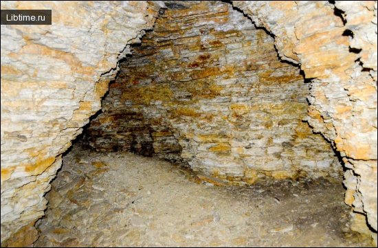
Soluble karst rocks — limestone, dolomite (dolomites), marble, chalk, and gypsum — dissolve in slightly acidic water, and they host the world's great cave landscapes. Carbonate rocks such as limestone and the dolomites yield broad galleries and richly decorated chambers, marble produces karst in metamorphosed carbonate terrains, chalk gives softer and more fragile cavities, and gypsum forms fast-evolving systems prone to collapse. The morphology in each varies with the rock's purity and bedding: pure massive limestone supports the largest grottoes, while interbedded units channel water along specific horizons.
Caves in Low-Solubility Rocks (Quartzite and Sandstone)
Caves in low-solubility rocks such as quartzite and sandstone form mainly by a slow combination of weathering and grain-by-grain disintegration rather than rapid dissolution. In quartzite, biochemical and chemical breakdown of the silica cement loosens the rock fabric so that water can flush out the grains, a process documented in tropical tepui systems and in the Galician highlands. Galician cave systems studied by Juan Ramón Vidal-Romaní and colleagues at the University of A Coruña, including sites in the Serra do Courel and across Galicia, are key references for how genuine caves develop in these resistant siliceous rocks.
Caves in Non-Soluble Rocks (Granite and Metamorphic Rocks)
Caves in non-soluble rocks such as granite and metamorphic rocks are pseudokarst features, formed by fracturing, block movement, boulder piling, and bioweathering rather than chemical dissolution of the rock mass. Granite caves often develop as talus voids beneath stacked boulders or along widened joints, and researchers including Marcos Vaqueiro Rodríguez have mapped extensive granite cave networks in Galicia. These cavities matter for morphodiversity and geodiversity because they show that the underground landscape is not confined to limestone country but extends into the most chemically stable rocks on Earth.
Development Stages of Karst Landscapes
Karst landscapes develop in recognisable stages, beginning with water finding fractures in soluble rock and ending with mature cave systems, sinkholes, and integrated underground drainage. Early karst shows scattered solution pockets and shallow ponors; mature karst displays interconnected conduits, large grottoes, and surface collapse; old-age karst leaves residual towers and sediment-choked passages. Geological monitoring of karst tracks this evolution through water chemistry, cavity surveys, and the dating of deposits.
Dissolution of Bedrock and Cave Formation
Dissolution of bedrock is the primary engine of cave formation in soluble rocks, as rainwater charged with carbon dioxide becomes weak carbonic acid and slowly removes carbonate along fractures. Where this dissolution reaches the surface it opens sinkholes, the funnel-shaped depressions that feed water underground and mark the recharge zones of karst aquifers. As conduits enlarge and connect, the discharge of underground water concentrates into springs, so the whole system behaves as a single hydraulic network from sinkhole intake to spring outflow.
Bioweathering in Underground Water Circulation
Bioweathering contributes to underground water circulation by accelerating rock breakdown through microbial activity, root acids, and the metabolic products of cave organisms. In quartzite and granite caves this biochemical weathering is often more important than pure dissolution, loosening mineral grains so that circulating water can carry them away. The process links the biological and hydrological components of the underground landscape, showing why caves cannot be understood through geology alone.
Cave Minerals and Mineralogy
Cave minerals — collectively the speleothems that decorate cavities — record the chemistry of the waters that built them, and their study is a branch of mineralogy in its own right. Speleothem development produces stalactites, stalagmites, flowstone, and rarer crystalline forms as carbonate or, in gypsum caves, sulfate precipitates from dripping and seeping water. The variety of these cave decorations contributes directly to morphodiversity, and the same minerals that form the decorations — calcite, aragonite, gypsum — fingerprint the rock and water that produced them.
Underground Climate and Microclimatic Conditions
The climatic conditions of caves are peculiar microclimates governed mainly by the cave's geographical position and its morphological structure, and they make underground spaces strikingly stable compared with the surface. The composition of cave air differs from atmospheric air: in most studied caves of the Crimea the carbon dioxide content was 0.3–0.5%, 10–15 times higher than outside, and in certain Crimean mines (Bezdonnaya, Khod Konem, Molodezhnaya, and Profsoyuznaya) it reaches 5–7%. The main source is infiltration water enriched with carbon dioxide as it seeps through the soil, supplemented by the oxidative decomposition of organic matter and, in tectonically disturbed areas of the mountainous Crimea, by deep nitrogen-carbon-dioxide and nitrogen-methane gas jets.
Cave air temperature varies widely but stays low and positive in most cases, depending on the cave's morphology, size, depth, entrance orientation to prevailing winds, and regional climate. The Serpievskaya cave (170 m long) on the western slope of the Southern Urals shows this vividly: at an outside temperature of 22.5° the air was −2° in the near and middle sections, where the floor dips, and 12° in the far section, where it rises — a 14° swing over just 85 m caused by morphology alone. Blind sloping cavities above the entrance stay warm because warm air rises and is trapped, while bag-shaped cavities below the entrance stay cold because dense cold air stagnates in them.
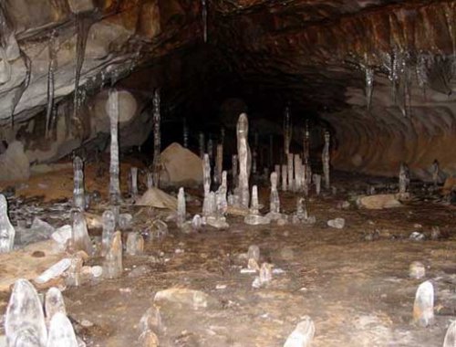
Caves typically hold very high relative humidity, usually 98–100%, though it fluctuates seasonally — in the Diamond Grotto of the Kungur Ice Cave humidity drops to 67% in autumn but rises to 95% in winter. These thermal and humidity properties give underground spaces a near-constant temperature year round in their deeper reaches, which is exactly why humans have prized them for storage, shelter, and cultivation. According to their temperature regime, karst caves are classed as warm (above the area's mean annual temperature), moderate (equal to it), or cold (below the mean annual surface temperature).
Microclimate dynamics divide large caves into zones and into three principal types:
- Dynamic — sharp changes in meteorological components over short intervals, near entrances with strong air exchange;
- Statodynamic — intermediate behaviour combining variable and stable conditions;
- Static — constant climatic conditions over long periods, typical of deep, sheltered interiors.
Hydrology of Underground Landscapes
The hydrology of an underground landscape couples flowing water with circulating air, and the two together carve, decorate, and ventilate the cave. Water flow in karst systems concentrates along fractures into conduits that move quickly between sinkhole recharge and spring discharge, making karst aquifers some of the most productive — and most vulnerable — groundwater sources on Earth. The same conduits that supply abundant drinking water also transmit pollution rapidly, which is why groundwater management in karst terrain demands special care.
Karst Water and Air Circulation in Caves
Karst water and air circulation in caves are driven by density differences between outside and underground air, the morphology of the cavity, the action of karst rivers that drag air inward during floods, and the external wind. In winter, cold air sinks into horizontal caves and forces warmer cave air out through cracks and organ pipes, where it freezes into a "frost fog" of ice crystals; in summer the flow reverses, with cold air draining from lower galleries while warmer outside air enters through vertical shafts, cools, and condenses, releasing heat and raising humidity toward 100%. Air exchange rates measured in Crimean caves range from once every five days in snow-floored caves to 157 times a day in narrow crack-shaped mines, averaging 14 times a day along the main ridge of the Crimean Mountains.
Inclined and vertical caves circulate air according to their shape. Inclined caves whose closed end lies above the entrance are warm, drawing in and trapping summer air while staying static in winter; bag-shaped caves descending from the entrance are cold, severely chilled in winter and stagnant in summer, and vertical shafts behave similarly. In the Kungur Ice Cave air moves inward about 182 days and outward about 170 days a year, with a 7–10 day standstill in mid-April and early October; daily fluctuations also occur, with the entrance airflow in July rising from 2.2 m/sec at night to 5.1 m/sec by day. Airflow in vertical caves is slight — a small Crimean mine averaged only 0.006 m/sec in the measurements of V. N. Dublyansky and V. V. Ilyukhin (1971).
Contamination Risks in Karst Aquifers
Contamination risks in karst aquifers are unusually high because pollutants entering a sinkhole travel through open conduits with little filtration before reaching a spring or well. Water quality issues in karst include rapid bacterial contamination, turbidity spikes after storms, and the transport of agricultural and industrial chemicals over long distances in days rather than years. Protecting karst drinking water therefore relies on safeguarding the entire recharge area — every sinkhole, swallow hole, and losing stream — rather than just the point of extraction.
Biogeography of Underground Landscapes
The biogeography of underground landscapes is defined by specialised organisms adapted to permanent darkness, stable temperature, high humidity, and scarce food. Cave communities range from bats and crickets near entrances to blind, depigmented invertebrates and microbial mats deep inside, and these microbes participate directly in bioweathering and mineral deposition. Because each cave is an isolated habitat island, underground biogeography is highly endemic, adding a living dimension to the morphodiversity and geodiversity already supplied by the rock.
Paleoclimate Evidence from Stalagmite Analysis
Stalagmite analysis provides some of the most precise paleoclimate evidence available, because speleothems grow in annual or seasonal layers whose chemistry records past rainfall and temperature. Luminescence dating and uranium-series methods place these layers on an absolute timescale, allowing climate change to be reconstructed across tens of thousands of years from a single column of calcite. Studies published through Springer Nature and other scientific publishers have used stalagmite records to document abrupt climate shifts, confirming caves as archives of the Earth's atmospheric history.
Human Use of Underground Landscapes
Humans have used underground landscapes for shelter, burial, storage, defence, agriculture, and architecture for thousands of years, exploiting the same stable temperature and protection that make caves distinctive natural complexes. Historical cave dwellings and troglodyte structures housed entire communities, while later cultures dug quarries, crypts, bunkers, and even gardens beneath the surface. These uses span the prehistoric to the contemporary, linking natural caves to engineered subterranean space.
Notable forms of human underground use include:
- Cave dwellings and troglodyte sites — caves and cave dwellings adapted as homes, churches, and storerooms across the Mediterranean and beyond.
- Quarries and mining operations — underground quarries and mine shafts with their access systems, where mineral and precious-metal extraction proceeds via shafts and underground accesses, raising water-management and environmental-and-social impacts that mining engineers must control.
- Crypts and ossuaries — funerary spaces where bone arrangement and burial ritual created landmarks such as the Paris Catacombs, born from the Paris underground quarries.
- Defence shelters — bunkers and civilian protection facilities, including the First World War shelters carved into French limestone known as the creutes.
- Underground agriculture and hospitality — the Forestiere Underground Gardens in Fresno, California, where Baldassare Forestiere hand-dug fruit gardens and irrigation channels, now Historic Landmark No. 916, alongside modern underground hotels and wineries such as the Antinori cellars near the Badia di Passignano Monastery in Tuscany.
Archaeological and Excavation Site Architecture
Archaeological and excavation site architecture studies how people shaped the ground itself — through hand-tool excavation techniques, stepwells, and ancient staircases — to live and work below the surface. The creutes of the French chalk and limestone country, expanded as World War I shelters, and the rock-cut stepwells of Rajasthan show two extremes of the same impulse to descend into the rock. Baldassare Forestiere, a Sicilian immigrant to the Central Valley of California, spent four decades from the early twentieth century excavating the Forestiere Underground Gardens entirely by hand, demonstrating how excavation technique alone can create a livable subterranean landscape.
Buried and Subterranean Architecture Concepts
Buried and subterranean architecture concepts treat the ground as both shelter and insulation, exploiting the thermal stability of underground spaces for energy efficiency and minimal visual impact. These ideas connect to groundscrapers — long, low, horizontally extended buildings that spread across or into the land rather than rising like skyscrapers, valued for land-use efficiency, green roofs, and integration with terrain and topographic site models. Architects such as Alberto Campo Baeza and firms including Oppenheim Architecture have explored sunken museums, underground parking, ramped and sloped designs, and desert site plans, with projects covered by Dezeen, Forbes, and discussed in programmes at the Rice School of Architecture, showing how the underground landscape continues to shape contemporary building.
For more articles on speleology and the natural world, see our Speleology and Travel sections, or return to the homepage to browse all topics.