Ice Caves Explained: Sublimation Processes and Crystal Formations Inside Caves
 libre
libre
The Apostle Islands Ice Caves are a rare winter phenomenon along the Lake Superior shoreline of Apostle Islands National Lakeshore in northern Wisconsin, accessible on foot only when the lake freezes solid enough for the National Park Service to declare safe passage across the ice. In the most spectacular years, visitors hike across the frozen lake to reach sandstone sea caves draped in ice stalactites, frozen waterfalls, and curtains of crystalline ice. Access is never guaranteed: it depends entirely on ice thickness, weather, and wind, and in many winters the caves never open at all.

What Are the Apostle Islands Ice Caves?
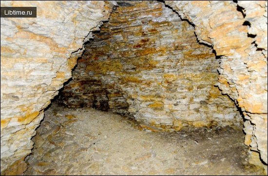
The Apostle Islands Ice Caves are sea caves carved into the mainland sandstone cliffs near Meyers Beach, on the Bayfield Peninsula in Bayfield County, Wisconsin. During exceptionally cold winters, waves and spray that normally crash against the cliffs freeze in place, coating the cave mouths and interiors with ice formations. The caves sit within Apostle Islands National Lakeshore, a unit of the National Park Service that protects 21 islands and a stretch of mainland coast on Lake Superior.
The mainland ice caves are reached by walking across the frozen surface of Lake Superior itself, which is what makes them so unusual and so dependent on conditions. The nearest towns are Cornucopia and Bayfield, with the trailhead at Meyers Beach (sometimes spelled Myers Beach) off Highway 13 between Cornucopia and the community of Bayfield. When the lake ice is judged safe, the route hugs the shoreline below the cliffs.
The Natural Phenomenon Behind the Ice Caves
The ice caves form through a combination of lake spray, freezing temperatures, and groundwater seeping through the sandstone, producing formations that range from delicate sublimation crystals to massive frozen columns. The physics behind cave ice is the same in the sea caves of Lake Superior as it is in karst caves studied for over a century, and understanding it explains the textures and colors visitors photograph each winter.
Among sublimation formations, ice crystals formed as a result of the interaction of relatively warm air with cooled objects are of the greatest interest. They have the most diverse shapes, determined by the temperature regime, humidity, and the direction and speed of air flows (Dorofeev, 1969). There are leaf-shaped crystals (formed at temperatures of -0.5 to -2°), pyramidal (-2 to -5°), rectangular-plate-shaped (-5 to -7°), needle-shaped (-10 to -15°), and fern-shaped (-18 to -20°).
How Cave Ice Formations Develop
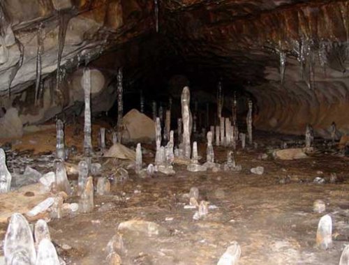
Cave ice develops along two main pathways: sublimation crystals that grow directly from water vapor, and infiltration forms that grow when liquid water freezes into stalactites, stalagmites, and crusts. The same processes that decorate the Apostle Islands sea caves with frozen waterfalls operate in limestone and gypsum caves worldwide.
Sublimation Ice Crystals
Sublimation ice crystals are among the most beautiful cave ice formations, growing directly from vapor onto cold cave surfaces. The most striking are pyramidal crystals, usually represented by clusters of spiral pyramids up to 15 cm across. Occasionally, relatively regular closed hexagonal pyramids with the top facing the ceiling appear on cave vaults.
Fern-like crystals form in severe frosts and look like thin plates (0.025 mm thick) up to 5 cm long, hanging in a dense fringe from the cave ceiling. These crystals are ephemeral; at a slight increase in temperature they are destroyed. The crystals often form sparkling garlands, openwork lace, and transparent curtains. Ice crystals are transparent and very fragile — when touched, they shatter into small pieces that slowly fall to the cave floor.
Types of Ice Crystals by Temperature
The shape of a sublimation crystal records the temperature at which it grew, making crystal form a direct readout of cave conditions:
- Leaf-shaped crystals — -0.5 to -2°
- Pyramidal crystals — -2 to -5°
- Rectangular-plate-shaped crystals — -5 to -7°
- Needle-shaped crystals — -10 to -15°
- Fern-shaped crystals — -18 to -20°
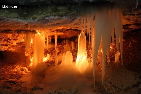
Ice Stalactites, Stalagmites and Stalagnates
Ice stalactites, stalagmites, and stalagnates are infiltration forms of hydrogenic origin, created when water passes into the solid phase as it freezes. These ice stalactites, stalagmites, and stalagnates can reach 10 meters in height and 3 meters in diameter. Their age varies from 2-3 months to several years; in the Kungur cave, for example, there is an ice stalagmite whose age exceeds 100 years.
By chemical composition, the ice of stalactites, stalagmites, and stalagnates can be fresh, with up to 0.1% (1 g/l) soluble substances, or brackish, containing soluble substances from 0.1 to 1%. Fresh ice is usually found in carbonate caves and brackish ice in sulfate caves.
Icing Crusts on Walls and Vaults
Icing crusts coat the walls and vaults in the cold part of some caves, forming both from water freezing as it flows down cracks and from sublimation of water vapor. The thickness of an icing crust usually varies from a fraction of a millimeter to 10-15 cm. The ice is transparent, sometimes milky-white, and either fresh (soluble substances less than 1 g/l) or brackish. The age of the ice crust can vary widely, and in some cases it is perennial.
Cover Ice on Cave Floors
Cover ice develops on the floor of grottoes and passages of ice caves, formed by hydrogenic or heterogeneous processes. Its thickness varies from several centimeters to several meters, with perennial, often layered ice prevailing; firn occurs in areas of snow accumulation. The chemical composition of cover ice depends on the karst rocks present — fresh and brackish ice are distinguished, with the latter in gypsum caves showing a calcium-sulfate composition. Mineralization of cave ice reaches 0.21%.
Of particular interest are ice crystals formed on the cave floor during the solidification of infiltration water. They take the form of conjoined needles with plates growing from below. Congelation ice is represented by the ice of underground lakes and rivers: lake ice forms on the surface of underground lakes during the cold season or throughout the year, and its area depends on the size of the lake. In some cases it reaches 500 m², with an ice thickness of 0.15 m (Geographical Society lake in the Abogydzha cave, on the May River). When underground water bodies freeze, crystals in the form of six-pointed stars, 1 mm thick and up to 10 cm across, are sometimes formed.
Annual vs. Perennial Ice Formations
Annual ice formations are transparent, while perennial formations take on a milky-white color with a bluish or greenish tinge because of accumulated impurities — the same range of textures and colors visitors notice in the Apostle Islands caves.

Annual and perennial ice formations also differ in internal structure. As shown by M. P. Golovkov (1939), annual stalactites in the Kungurskaya Cave are optically uniaxial single crystals, while perennial stalactites consist of many layer-by-layer, elongated, partially faceted crystals oriented with their optical axes parallel to the length of the stalactite. Ice crystals at the cave entrance usually appear in spring and last for several months; only in some caves, especially in permafrost regions, are crystals perennial.
Chemical Composition and Mineralization of Cave Ice
The chemical composition of cave ice depends directly on the composition of the surrounding rock. According to E. P. Dorofeev (1969), the mineralization of annual sublimation ice crystals of the Kungur cave is 56-90 mg/l, while that of perennial ice crystals is 170 mg/l. Cave ice also contains various trace elements: spectral analysis of ice taken from the icing crust in the Brilliant Grotto of Kungurskaya Cave showed that strontium predominates, accounting for more than 0.1%, while the content of manganese, titanium, copper, aluminum, and iron does not exceed 0.001%.
According to the conditions of cave cold, snow, and ice accumulation, N. A. Gvozdetsky (1972) distinguishes seven types of karst ice caves in Russia and Ukraine:
- karst wells and chasms with snow and ice, where the ice forms from snow falling through the mouth opening in the cold season;
- bag-shaped cold caves, where ice can form by freezing of water coming from cracks;
- through, or blow-through, cold caves where the air draft changes direction between warm and cold half-years, with hydrogenic ice and atmogenic (sublimation) ice crystals;
- through-horizontal ice caves with a window in the ceiling through which snow enters and turns to ice;
- through, or blow-through, caves in permafrost areas, where cave ice takes a special form;
- well-shaped cavities in permafrost areas;
- bag-shaped cavities in permafrost areas.
Formation and Rarity of Ice Cave Accessibility
Walking access to the Apostle Islands Ice Caves is rare because it requires Lake Superior to freeze into a stable, continuous ice shelf anchored to the shoreline — a combination of conditions that occurs only in the coldest winters. The lake is large and deep enough that it rarely freezes completely, and even a partial freeze can be broken up quickly by wind and waves. The National Park Service has only declared the mainland ice caves accessible on foot in a handful of winters over the past few decades.
For the ice to be safe, the shelf must be thick, well anchored, and have solid land contact points along the route below the cliffs. Wind and wave action constantly test the ice shelf's integrity; a strong offshore wind can shift or fracture the shelf within hours, which is why the route can open and close repeatedly within a single season. Years with sustained sub-zero temperatures and calm conditions produce the seasonal window that allows visitors in, while milder or windier winters keep the caves off-limits entirely.
Access and Opening Conditions
The Apostle Islands Ice Caves are only open when the National Park Service confirms the lake ice is safe to cross, and that determination can change day to day. There is no fixed season — some years see weeks of access, others none. Before planning a trip, visitors must check the official status rather than assume the caves are open.
How to Check if the Ice Caves Are Open
Check the official National Park Service status before traveling, because conditions are evaluated continuously and access is never guaranteed in advance. Rangers test the ice with augers to measure thickness and monitor it against wind and temperature forecasts before declaring the route open or closed. NOAA CoastWatch ice data and lake-condition forecasts from The Weather Channel can supplement the official update, but the Park Service decision is the only authority on whether you may walk to the caves.
Emergency Closures and Rapid Status Changes
Emergency closures can happen with little warning when wind, rising temperatures, or shifting ice make the shelf unsafe. The most cited example of rapid deterioration came when a storm system nicknamed the Mardi Gras Blizzard moved through the region, dramatically changing ice and access conditions in a short period. Because Lake Superior ice is inherently unpredictable, rangers will close the route mid-day if monitoring shows the shelf weakening, and visitors already on the ice may be directed to return to shore immediately.
Communication Channels for Status Updates
Status updates are distributed through several channels so visitors can confirm conditions before driving to the trailhead:
- The National Park Service Apostle Islands National Lakeshore website and ice line for the official open/closed determination;
- The Bayfield Chamber and Visitor Bureau and Travel Wisconsin for regional travel information;
- Local lodging and businesses such as the Village Inn in Cornucopia and Legendary Waters Resort and Casino, which often share current conditions;
- Community discussion on Reddit and social media, useful for first-hand reports but never a substitute for the official status.
Getting There: Hiking Route and Distance
The hike to the ice caves starts at the Meyers Beach trailhead off Highway 13 and follows the frozen Lake Superior shoreline beneath the sandstone cliffs, a round trip of roughly four to five miles depending on how far along the cliff line the best formations are. Parking is at the Meyers Beach lot, where the National Park Service charges a per-vehicle fee, and the lot fills early on busy weekends when access is open.
Transportation logistics can be significant in peak years. When crowds surge, the Park Service and partners have used a shuttle bus system and traffic coordination to manage parking overflow and keep Highway 13 clear. The nearest services are in Cornucopia and Bayfield, with Bayfield serving as the main visitor hub for the national lakeshore.
Winter Activities and Alternative Routes
When the ice caves are closed, the Bayfield Peninsula and surrounding region still offer plenty of winter recreation, from groomed ski trails to lake-effect snowshoeing. Travelers who arrive only to find the caves off-limits have several worthwhile alternatives nearby.
Cross-Country Skiing Options
Cross-country skiing is a reliable alternative when lake ice access is closed, with trails near Bayfield and at Mt. Ashwabay offering groomed routes regardless of lake conditions. Mt. Ashwabay, just outside Bayfield, maintains Nordic trails and downhill terrain, making it a dependable winter destination that does not depend on Lake Superior freezing.
Fat Bike Restrictions on Frozen Terrain
Fat bikes are restricted on the frozen lake route to the ice caves, where the National Park Service limits travel to foot traffic for safety and to protect the fragile ice formations. Riders looking for winter cycling should use designated trails on land rather than the lake shelf, since bike traffic on uncertain ice raises both rescue and ice-integrity concerns.
Winter Photography Tips for the Ice Caves
Photographing the Apostle Islands Ice Caves rewards patience and flexibility, because the ice you find rarely matches the postcard image — formations melt, refreeze, and shift between visits. Landscape photographers including Bryan Hansel, who runs workshops in the Lake Superior region around Grand Marais, emphasize adapting composition to whatever the ice actually presents rather than chasing a preconceived shot.
Practical photography strategies for the ice caves include:
- Shoot the translucent blues and milky-white tones that perennial-style ice takes on, using backlight where spray ice catches low winter sun;
- Bring a wide lens for the cave-mouth curtains and a longer lens to isolate stalactite detail and ice texture;
- Protect gear from spray and cold, and let equipment acclimate to avoid condensation;
- Adapt your subject and composition to current conditions instead of relying on images from previous, better years;
- Arrive early for soft light and to avoid the crowds that build through the day when access is open.
Climate Change and Lake Superior Ice Coverage
Climate change is reducing the frequency and reliability of the lake ice that makes the ice caves accessible, as warmer winters shorten the window when Lake Superior freezes solid enough to cross. Long-term ice records, including data tracked by NOAA CoastWatch, show high year-to-year variability layered over a warming trend, which means walk-in access may become even rarer over time. The handful of accessible winters in recent decades underscores how sensitive the phenomenon is to temperature.
Environmental Concerns and Carbon Pollution
The decline in Lake Superior ice coverage is tied to broader environmental concerns about carbon pollution and warming winters across the Great Lakes region. Reduced ice affects not only tourism but lake ecology, shoreline erosion, and the seasonal patterns that communities around Apostle Islands National Lakeshore depend on. The ice caves have become a visible local symbol of how a warming climate reshapes a natural attraction that once seemed dependable.
Changes in Visitor Crowding at Natural Attractions
National media coverage transformed the Apostle Islands Ice Caves from a local secret into a destination drawing hundreds of thousands of visitors in the busiest seasons. When outlets such as Outside, Travel + Leisure, and The Weather Channel amplified the story, traffic to Meyers Beach surged far beyond what the small trailhead and Highway 13 were built to handle. This pattern — a rare natural phenomenon going viral and overwhelming a remote site — mirrors crowding pressures at other natural attractions and forced the National Park Service into active visitor management.
Managing those crowds required multi-agency coordination among the National Park Service, Bayfield County, and local communities, along with shuttle service, expanded parking strategy, and clear communication about when the caves were actually open. Visitor experience suffers when too many people arrive at once, so destination marketing through the Bayfield Chamber and Visitor Bureau and Travel Wisconsin increasingly balances promotion with realistic expectations about access and conditions.
Economic Impact of the Ice Caves
In accessible winters, the ice caves deliver a major economic boost to Bayfield County and the wider Wisconsin outdoor recreation economy, filling lodging, restaurants, and outfitters in an otherwise quiet season. Businesses from the Village Inn in Cornucopia to Legendary Waters Resort and Casino see demand spike when the National Park Service opens the route, and the influx supports a tourism economy that Wisconsin's Office of Outdoor Recreation counts among the state's significant assets.
The flip side is volatility: because access is unpredictable, businesses cannot count on ice-cave revenue from year to year, which makes the broader outdoor-recreation draw of the Bayfield Peninsula — kayaking, skiing, and island tourism in other seasons — essential to a stable local economy.
Community and Visitor Engagement
Local communities, the National Park Service, and tourism organizations work together to inform visitors, manage demand, and tell the ice caves' story responsibly. Engagement spans ranger-led information, social media amplification through regional accounts and occasional influencer partnerships, and media relations that put the Apostle Islands on national platforms. Personal accounts shared online — including photographer and visitor reports from people like Deborah Copperud and discussions among kayakers recovering from shoulder injuries after summer expeditions — add first-hand texture that helps prospective visitors set expectations.
Photographer workshop announcements, such as those tied to Lake Superior–based instructors, also build community around the attraction while reinforcing safe, low-impact practices. The aim across all these channels is to connect visitors with accurate, current information rather than hype, so that the rare seasons when the caves open are both memorable and safe.
Safety Guidelines for Visiting Ice Caves
The single most important safety rule is to go only when the National Park Service has officially opened the route, and to turn back the moment conditions look wrong. Lake Superior ice is unpredictable, and the cold water beneath it is immediately life-threatening if the shelf fails. Recommended preparation and gear for an ice cave hike includes:
- Traction devices such as Yaktrax or ice cleats for the slick lake surface;
- Layered insulated clothing, windproof outerwear, hat, and gloves for severe wind chill;
- Sturdy waterproof boots and trekking poles for stability on uneven ice;
- Plenty of water and high-energy food for a multi-mile round trip;
- A charged phone and awareness that cell coverage along the cliffs can be limited.
Watch the weather and wind during your visit, stay within the marked or established route, and keep away from cracks, open water, and undercut ice near the cave mouths. Because emergency closures can happen quickly, follow ranger instructions without delay and never attempt to extend a visit when temperatures rise or wind picks up. The ice formations themselves are fragile — keep clear of overhead icicles and unstable curtains that can collapse without warning.