Skelskaya Cave and the Deepest Caves of Crimea: A Speleologist's Guide
 libre
libre
Skelskaya Cave is a 570-metre karst cave on the western edge of the Ai-Petri Massif in Mountain Crimea, set on the slope of a small meridional spur of Mount Karadag. The cave is best known for its vast main grotto, an 8-metre-thick central column, and lower watered galleries fed by fault-controlled groundwater. It lies near the village of Skela in the Baydar Valley, within easy reach of the Baydar Gate and the Black Sea coast.
Skelskaya Cave: Overview and Location
Skelskaya Cave sits on the western rim of the Ai-Petri Massif, on the slope of a small meridional spur of Mount Karadag in Crimea. The cave is confined to a tectonic fault running in a north-western direction, which determined both its position and its internal layout. Its proximity to the Baydar Valley, the settlement of Skela, and the Baydar Gate makes it one of the more accessible natural monuments of the south-western Crimean Peninsula.
The cave is designated a natural monument and protected for its calcite formations and its rare cave fauna. With a total surveyed length of 570 metres, Skelskaya Cave ranks among the notable horizontal-vertical systems of Mountain Crimea, combining a dry upper grotto with deeper watered passages.
Geological Setting of the Ai-Petri Massif
The Ai-Petri Massif is built largely of massive Upper Jurassic limestone, the rock type that makes the western Crimean uplands one of the peninsula's classic karst regions. Limestone of this kind dissolves slowly in slightly acidic groundwater, and over geological time that dissolution carves the shafts, grottoes, and galleries that characterise caves such as Skelskaya. The massif's elevation and its fractured limestone together create the conditions for both surface karst features and deep underground drainage.
Karst topography across the Ai-Petri Massif and the wider Mountain Crimea includes sinkholes, dry valleys, springs, and an extensive network of caves and vertical mines. These geological formations form the framework within which the region's karst aquifer system collects, stores, and discharges water, often in a landscape that is otherwise notably water-scarce at the surface.
Tectonic Faults and Cave Formation
Tectonic faults are the primary control on cave formation at Skelskaya Cave, which developed along a fracture trending north-west. Faults open pathways through otherwise massive limestone, concentrating groundwater flow and accelerating dissolution along the fracture plane. This is why the cave's main passages follow a consistent structural alignment rather than wandering randomly through the rock.
The same fault-and-limestone combination explains the cave's mixed character: erosion and corrosion by moving water enlarged the fault zone, while collapse of weakened limestone blocks produced the cluttered grotto floors and large wells seen today. Fault-controlled formation is a recurring theme across the deep vertical caves of the Ai-Petri and Karabi massifs.
Structure of Skelskaya Cave
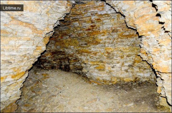
Skelskaya Cave is organised into a dry upper grotto and a lower watered level, linked by narrow horizontal and steeply sloping passages and wells. The upper section is the showpiece, dominated by collapsed limestone blocks and heavy calcite concretions, while the lower section carries the cave's groundwater. The vertical separation between the two levels is about 45 metres.
The Main Grotto and Central Column
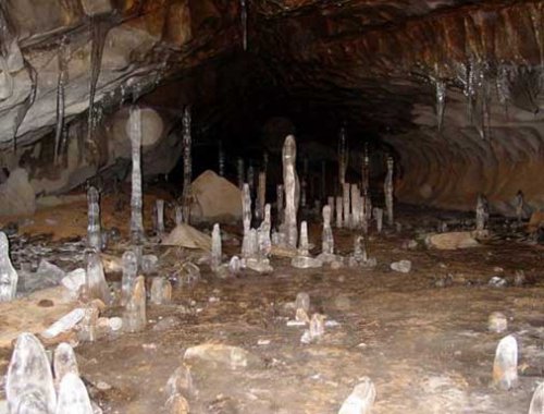
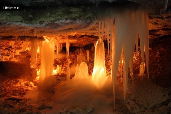
The main grotto occupies the upper part of Skelskaya Cave, its floor cluttered with limestone blocks coated in powerful calcite concretions. The defining feature is a huge column 8 metres in diameter and 12 metres high, which divides the grotto into two parts. Towards the north-east, the main grotto opens into a huge well formed of collapsed limestone blocks, marking the transition toward the deeper cave.
Stalactites, stalagmites, and massive flowstone columns like this central pillar form where mineral-laden water drips and flows over long periods, depositing calcite. The scale of the Skelskaya column makes it one of the more impressive single speleothems in Crimean caves.
Lower Watered Galleries and Passages
The lower, watered part of Skelskaya Cave lies about 45 metres below the entrance and contains several smaller grottoes connected to each other and to the upper galleries. These connections take the form of a system of narrow horizontal and steeply sloping passages and wells. It is this watered level that gives the cave its hydrological interest, channelling groundwater through the fault-aligned network.
Cave Hydrogeology and Water Dynamics
Skelskaya Cave is part of a karst aquifer system in which groundwater moves through fractured Upper Jurassic limestone toward springs at lower elevations. The cave's watered galleries, lakes, and seasonal floods make it a useful natural window into how karst water behaves in Mountain Crimea. Long-term hydrological monitoring of karst caves like Skelskaya helps researchers understand the karst water regime that supplies the region's springs.
Researchers studying Crimean karst, including teams associated with the Vernadsky Crimean Federal University, the Water Problems Institute of the Russian Academy of Sciences, and the Complex Karst Expedition, have applied a range of hydrogeological interpretation methods to such systems. These include measurements of specific conductance, temperature, isotopic composition of the water, and spring discharge correlation analysis to trace where the water originates and how quickly it moves.
Fault-Controlled Groundwater Flow
Groundwater in Skelskaya Cave follows fault-controlled pathways, flowing preferentially along the same north-western fracture that guided the cave's formation. In limestone formations, faults act as high-permeability conduits, so the bulk of the discharge concentrates along these structural weaknesses rather than seeping uniformly through the rock. Mapping these conduits is central to understanding any karst aquifer system.
Identifying multiple recharge areas is part of this work. In the broader Ai-Petri and Baydar karst, features such as the Karadagskii fault and recharge zones like the Karadagskii and Tarpanbairskii recharge areas feed water toward outlets including the Skelskii spring near Rodnikovskoe. Distinguishing these contributions relies on combining physicochemical characteristics of the karst water with discharge records.
Cave Lakes and Hydrodynamics
Cave lakes form in the watered lower galleries where passages dip below the local water table, and their levels and temperature respond to recharge from the surface. Temperature dynamics in cave lakes tend to be muted compared with surface water, since the rock buffers seasonal swings, but inflows of fresh infiltration water can produce measurable shifts. In several Crimean caves, paired eastern and western lakes show how water bodies within a single system can behave differently depending on their connection to active flow.
Cave lake hydrodynamics — the way water levels rise, fall, and circulate — reflect the balance between recharge and discharge in the surrounding karst. Monitoring these changes, alongside specific conductance, gives a picture of how quickly water passes through and how much storage the aquifer holds.
Flood Events and Seasonal Water Levels
Flood events sharply raise water levels in the lower passages of Crimean karst caves, sometimes by many metres within a single high-recharge period. In Kaskadnaya Mine on the Ai-Petri Massif, for example, floods fill the lower part of the cave with infiltration water to a height of 8 to 13 metres. Water level variations of this magnitude characterise karst systems, where rapid conduit flow translates surface rainfall and snowmelt into fast underground responses.
Characterising flood events helps separate baseflow from storm-driven flow and reveals how elevation-dependent water flow patterns develop across a massif. The timing and size of these pulses, correlated with spring discharge, indicate how directly a given cave connects to its recharge area.
Cave Fauna: The Troglobiont Bokoplava
A typical troglobiont — the bokoplava, a cave-adapted amphipod crustacean — was found living in the waters of Skelskaya Cave. Troglobionts are species that complete their entire life cycle underground and are usually adapted to permanent darkness, often with reduced eyes and pigmentation. The presence of the bokoplava confirms that the cave's lower galleries support a stable aquatic habitat fed by the karst aquifer.

Discovery and Exploration History
The exploration of Skelskaya Cave and the wider Crimean karst is tied to the systematic speleological surveys that mapped the peninsula's caves and recorded their fauna and formations. Early documentation noted the main grotto, the central column, and the watered lower level, while later speleological research extended into the connected passages and the cave's hydrology. Some sections of Crimean caves remain incompletely explored, leaving scope for further survey and archaeological excavation where ancient human habitation or paleontological remains may be preserved.
Modern research has carried this documentation forward. Studies supported by bodies such as the Russian Science Foundation and carried out by specialists including G. N. Amelichev and S. V. Tokarev have applied isotopic and physicochemical methods to Crimean karst water, turning caves like Skelskaya from purely descriptive curiosities into monitored components of a regional karst aquifer system. This combination of archaeological, natural heritage, and hydrogeological interest underlines why the cave is treated as a protected natural monument.
Major Vertical Caves and Mines of Crimea
Beyond Skelskaya Cave, Mountain Crimea contains some of the deepest vertical caves in the region, concentrated on the Karabi and Ai-Petri massifs. The largest vertical cavities include Soldatskaya (470 m deep), Molodezhnaya (261 m), Kaskadnaya (246 m), Khod Konem (213 m), Sevastopolskaya (196 m), Gvozdetsky (191 m), and Bezdonnaya (161 m) mines. These shafts and well systems formed by erosion and corrosion along tectonic faults in Upper Jurassic limestone, and many carry active streams or lakes at depth.
Soldatskaya Mine (470 m)
Soldatskaya Mine is the deepest vertical cave in the group, reaching 470 metres, and it lies on the Karabi massif about 10 km from the village of Krasnoselovka. Its near part is a sloping gallery that, in Tithonian reef limestone, gives way to a cascade of wells and shafts between 10 and 85 metres deep, alternating with narrow horizontal passages and grottoes. Some of its grottoes rise to 23 metres in height.
From a depth of 435 metres a stream flows constantly along the bottom of the cave, and lakes occur within the system. Nate (flowstone) formations are widespread throughout. The total surveyed length of Soldatskaya Mine is 1700 metres against its 470-metre depth, making it both deep and extensive.

Molodezhnaya Mine (261 m)
Molodezhnaya Mine, 261 metres deep, sits at the bottom of a karst sinkhole on the Karabi massif (for context on why caves matter, see the importance of caves). It formed in massive Upper Jurassic limestone along a tectonic fault and is of erosion-corrosion origin, comprising a system of vertical cavities separated by small ledges or pads. Carrs (solution grooves) are developed on its walls, with small deposits in the lower part and an air temperature of about 8°C.
Kaskadnaya Mine (246 m)
Kaskadnaya Mine, 246 metres deep, lies at the bottom of a huge sinkhole in the central part of the Ai-Petri Massif and formed in the Upper Jurassic limestones. The mine is a system of cascades, from 17 to 53 metres deep, between which inclined galleries hold smaller ledges of 2 to 3 metres. Its walls are corroded down to about 100 metres and below that are coated with a thin calcite concretionary crust.
Small lakes occur at depths of 213 and 233 metres from the surface, and during floods the lower part of the cave fills with infiltration water to a height of 8 to 13 metres. The air temperature below 60 metres is about 5.1°C. Kaskadnaya is a relict formation, now largely abandoned by water: it owes its origin mainly to the erosion-corrosion action of ancient water flows, with modern flows playing a relatively small role in shaping it.
Other Notable Mines: Khod Konem, Sevastopolskaya, Gvozdetsky, Bezdonnaya
Several further vertical caves round out the deep systems of Mountain Crimea, each formed by the same fault-guided erosion-corrosion processes in Upper Jurassic limestone:
- Khod Konem — 213 metres deep, a vertical system of shafts and connecting passages.
- Sevastopolskaya — 196 metres deep, among the more developed mines of the region.
- Gvozdetsky — 191 metres deep, another fault-controlled vertical cavity.
- Bezdonnaya — 161 metres deep, completing the group of major Crimean mines.
Elevation-Dependent Water Flow Patterns in Vertical Caves
Water flow in Crimean vertical caves is strongly elevation-dependent, with infiltration entering at the surface, descending through cascades of shafts, and accumulating as streams or lakes at depth. In Soldatskaya Mine, the constant stream begins only from about 435 metres down, showing how flow concentrates toward the base of the system. These elevation-dependent water flow patterns link individual mines to the broader karst aquifer system and to the springs that drain it.
Comparing flood behaviour, lake depths, and stream onset across mines such as Kaskadnaya and Soldatskaya reveals how recharge translates into discharge at different points on a massif. This kind of comparison feeds spring discharge correlation analysis, helping researchers match underground flow to outlets like the Skelskii spring.
Visiting Skelskaya Cave
Skelskaya Cave is open to visitors as a show cave near the Baydar Valley, with guided underground excursion routes through the main grotto and past the central column. The cave offers year-round visitor access in most conditions, and tours highlight its calcite formations and the contrast between the dry upper grotto and the watered lower level. It pairs naturally with a wider trip through the south-western Crimean Peninsula.
Getting There: Flights and Car Hire in Sevastopol
The most practical base for reaching Skelskaya Cave is Sevastopol, from which the Baydar Valley and the village of Skela are a short drive away. Trip planning typically combines flights to the region with car hire in Sevastopol, since a vehicle gives the flexibility to combine the cave with mountain passes and coastal viewpoints. Travel booking integration that compares prices across providers and shows free cancellation options makes it easier to assemble flights, a hire car, and accommodation in one itinerary.
Accommodation Options Nearby
Accommodation near Skelskaya Cave ranges from guesthouses in the Baydar Valley villages to 4-star hotels in Sevastopol and along the Yalta coast. When choosing a base, useful selection criteria include:
- Location relative to the cave and the Baydar Gate, ideally shown on a map.
- Guest ratings and reviews to gauge quality.
- Flexible check-in and check-out dates with free cancellation.
- Hotel deals and discounts found by comparing prices across providers.
- Search and filtering tools to narrow options to 4-star or family-friendly stays.
Crimean Peninsula Attractions and Nearby Sites
Skelskaya Cave sits within a cluster of Crimean Peninsula attractions that combine natural and historical heritage. Close by are the Baydar Gate, a historic mountain pass above the Black Sea, and the Foros Church (the Church of Christ's Resurrection), built on a clifftop in memory of the survival of Emperor Alexander III's family in the Borki train disaster. The surrounding Mountain Crimea offers scenic views, mountain passes, springs, and dog-friendly walking routes between villages such as Rodnikovoye and Kolkhoznoyeh.
Hikers planning routes around the Ai-Petri Massif and the Baydar Valley often use walking apps such as the Pacer Walking App to follow trail details, elevation gain and distance metrics, difficulty ratings, and user-generated trail reviews. These tools help match a route to ability and highlight recommended alternatives toward viewpoints over the Black Sea coast.
360-Degree Panoramic Views and Photography
360-degree panoramic photography offers a way to preview Skelskaya Cave and the surrounding Crimean landscape before visiting, through immersive virtual tours. Spherical images let viewers pan, zoom, and switch between viewing modes to explore the main grotto, the central column, and nearby scenic overlooks as if standing on the spot. High-resolution spherical panoramas are typically shared and embedded from photography platforms.
Contributors publish such panoramas on platforms like 360Cities and 360px.org, where each image carries its own resolution specifications and licensing terms. Usage generally falls into two categories — non-commercial usage rights for personal sharing and embedding, and commercial licensing for panoramic content used in publications or products. For more travel features, see our Travel section and related Speleology articles.
Note on viewing virtual tours: interactive panoramas require JavaScript to be enabled in your browser, and an ad blocker or strict privacy settings may prevent embedded viewers from loading. If a tour or a page fails to display, enabling JavaScript, adjusting browser settings, or pausing the ad blocker usually restores it; if you reach an Error 404 - Page Not Found message, returning to the homepage and navigating again is the simplest recovery.