Shemakha Cave: Explore the Magnificent Karst Wonder of the Middle Urals
 libre
libre
Shemakha Cave is the largest cave in the Middle Urals, stretching 1,660 metres through the Devonian limestones of the Bardymsky Ridge on the right bank of the Shemakha River, a tributary of the Ufa River, near the village of Skaz. The cave is best known for its dramatic spring flooding, when a stream bursts from its mouth at rates of up to 4,000 litres per second, and for the stalactites, stalagmites, and ice formations found within.
Geographic Location and Coordinates
Shemakha Cave sits in the Middle Urals of Russia, opening onto the right bank of the Shemakha River close to the village of Skaz. The cave belongs to the karst landscape of the Bardymsky Ridge, a region where soluble limestone bedrock has produced one of the most extensive underground systems in the Ural Mountains.
Location on the Shemakha River
The Shemakha River, a tributary of the Ufa River, defines the immediate setting of Shemakha Cave. The cave entrance lies on the river's right bank, and the watercourse plays a direct role in the cave's hydrology — much of the water that floods the passages in spring drains back into the Shemakha River system once the snowmelt subsides.
Distance and Access from Nearby Villages
The nearest settlement to Shemakha Cave is the village of Skaz, which serves as the main reference point for travellers seeking the cave. From Skaz, the approach follows the valley of the Shemakha River to the limestone slope of the Bardymsky Ridge where the entrance is found. The remoteness of the location means visitors should plan for a walk-in approach rather than direct vehicle access to the cave mouth.
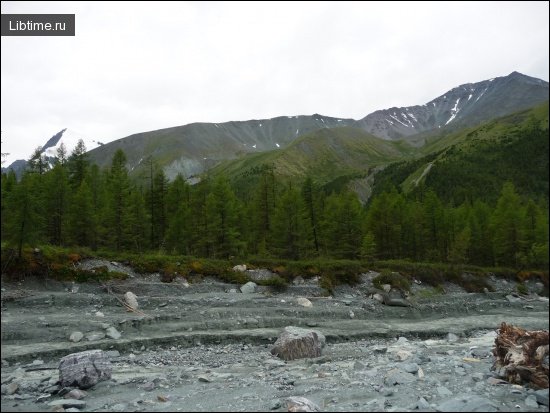
Altitude and Topographical Features
The entrance to Shemakha Cave is positioned 3 metres above the water's edge of the Shemakha River, set into the slope of the Bardymsky Ridge. The surrounding topography is shaped by karst processes: the dissolving of reef limestone over geological time has carved sinkholes, fissures, and the extensive passage network for which the cave is known. The ridge itself forms part of the rolling, forested relief typical of the Middle Urals.
Geological Formation
Shemakha Cave formed within massive reef limestones laid down during the Devonian period, on the slope of the Bardymsky Ridge. These limestones are highly soluble in slightly acidic groundwater, and over many thousands of years that water has enlarged natural fractures into the chambers and corridors of the present cave.
Devonian Reef Limestones of the Bardymsky Ridge
The Devonian reef limestones of the Bardymsky Ridge are the geological foundation of Shemakha Cave. Reef limestones are particularly prone to karstification because of their porosity and chemical composition, which explains why the Bardymsky Ridge hosts the largest cave system in the Middle Urals rather than smaller, isolated cavities.
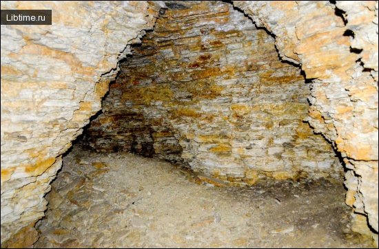
Cave Structure and Dimensions
Shemakha Cave has a complex structure with a total surveyed length of 1,660 metres, making it the longest cave in the Middle Urals. Its layout combines narrow passages, wider galleries, and water-filled sections that change character with the seasons.
Entrance and Internal Layout
The entrance to Shemakha Cave is a vertical crack up to 1.5 metres wide, set 3 metres above the river's water level.

Total Length and Passages
The combined length of the passages in Shemakha Cave reaches 1,660 metres. The corridors are not arranged in a single line but branch through the limestone of the Bardymsky Ridge, linking chambers, low crawls, and sections that hold standing water for much of the year.
Hydrology and Seasonal Water Flow
Water dominates the behaviour of Shemakha Cave and varies dramatically across the year. In spring the cave fills and discharges a powerful stream, while in late summer and winter the water retreats to scattered streams and deep lakes inside the passages.
Spring Flooding and Stream Flow Rates
From the end of April to mid-June, Shemakha Cave releases a rapid stream whose flow rate reaches 4,000 litres per second. This seasonal surge is driven by snowmelt across the Bardymsky Ridge filling the cave, and it makes the spring months the most hazardous time to attempt entry.
Summer and Winter Lakes
In the second half of summer and in winter, the water in Shemakha Cave is reduced to small streams and lakes up to 5–6 metres deep. These standing pools persist within the lower passages even when the spring flood has drained, and they are a defining feature of the cave's quieter seasons.
Climate and Internal Conditions
The interior of Shemakha Cave maintains a cold, stable climate that contrasts sharply with the surface seasons of the Middle Urals. This constant chill shapes both the comfort requirements for visitors and the ice formations that appear in winter.
Air Temperature and Humidity
The air temperature in the middle and far parts of Shemakha Cave holds at about 4.5°C year-round. Combined with the deep lakes and flowing water, this gives the cave a high internal humidity. Anyone entering should expect persistently cold, damp conditions regardless of the temperature outside, which makes warm, water-resistant clothing essential.
Cave Formations and Features
Shemakha Cave is decorated with classic karst formations and, in the colder months, by striking ice features near its entrance. These mineral and ice structures are among the chief attractions for those who explore the cave.
Stalactites, Stalagmites, and Curtains
Inside Shemakha Cave, cylindrical stalagmites rise from the floor, elongated stalactites hang from the ceiling, and thin transparent curtains of calcite drape the walls. These formations grow slowly as mineral-rich water drips and evaporates, and their delicacy is part of what makes the cave's deeper galleries so visually impressive.
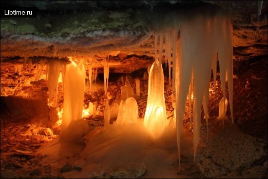
Winter Ice Formations
In winter, various ice formations develop in the near part of Shemakha Cave. Cold air drawn into the entrance zone freezes seeping water into ice columns, sheets, and crystalline shapes, creating a seasonal display that differs entirely from the calcite formations found deeper inside.
Flora, Fauna, and Cave Ecology
The ecology of Shemakha Cave is governed by its cold temperature, darkness, and seasonal flooding, which together limit life to hardy, shade-tolerant organisms. The entrance zone supports mosses and lichens adapted to low light, while the constant 4.5°C interior and deep lakes create a fragile habitat. Visitors should treat the cave's formations and any wildlife with care, since the dripping calcite and the cold-water environment recover extremely slowly from disturbance.
Visiting Shemakha Cave
Visiting Shemakha Cave means preparing for cold, wet, and dark conditions and timing the trip around the cave's flooding cycle. As the largest cave in the Middle Urals, it draws speleology enthusiasts, but its seasonal water makes planning essential.
Best Season to Visit
The best time to visit Shemakha Cave is the second half of summer or winter, when the water inside is limited to small streams and lakes rather than a torrent. The period from late April to mid-June should be avoided for entry, because that is when the cave discharges its powerful stream at up to 4,000 litres per second.
Safety and Caving Tips
Safe exploration of Shemakha Cave depends on the right gear and a cautious approach to its water and cold. Key precautions include:
- Avoid the cave during the spring flood from late April to mid-June.
- Wear warm, waterproof clothing for the constant 4.5°C interior and high humidity.
- Carry reliable lighting and a backup light source, since the passages are completely dark.
- Use sturdy footwear with good grip for wet, uneven limestone surfaces.
- Be aware of lakes up to 5–6 metres deep within the passages.
- Never explore alone, and tell someone your route and expected return time.
How to Get There
Reaching Shemakha Cave starts from the village of Skaz, the closest settlement, and follows the Shemakha River valley to the limestone slope of the Bardymsky Ridge. The final approach to the entrance, a vertical crack 3 metres above the river, is made on foot. For broader planning and ideas, our Travel and Speleology sections cover related destinations and caving guidance.
Etymology and Name Origin
The name Shemakha Cave derives from the Shemakha River on whose bank it opens, and the river name in turn echoes place names found across the wider region. The same root appears in the name of the city of Shamakhi in Azerbaijan — a historic centre on the Silk Road and former capital of the Shirvan realm — illustrating how the Shemakha and Shamakhi forms travel between languages and locations.
Alternative Spelling Forms
Shemakha Cave appears under several alternative spellings because the name is transliterated from Cyrillic into the Latin alphabet. Common variants include "Shemakhinskaya," "Shemakha," and "Shemaha," all referring to the same cave near Skaz. The variation arises from differing transliteration conventions rather than from any difference in the underlying Russian name.
Nearby Attractions in the Middle Urals
The Middle Urals around Shemakha Cave offer a karst landscape of rivers, ridges, and additional caves that reward longer exploration. The Shemakha and Ufa river valleys, the forested relief of the Bardymsky Ridge, and the wider speleological sites of the region make the area a destination for hikers and cavers alike. If you are mapping out a trip, our main library of travel, nature, and science articles collects further guides to natural landmarks and outdoor destinations.