Red Cave in Crimea, Ukraine: A Speleological Guide to the Dolgorukovsky Massif
 libre
libre
The Red Cave (Kizil-Koba) is the longest cave in carbonate rocks across the former USSR, located in Crimea on the western slope of the Dolgorukovsky massif near the village of Perevalnoye, 23 km from Simferopol. The Red Cave formed in Upper Jurassic limestone and has a total surveyed length of 13,100 metres, making it one of the most significant karst systems in the region.
The main part of the Red Cave, running from the Second to the Fifth Collapse Hall, follows a north-west direction and is laid along the dip of the limestone beds. The principal role in forming these underground cavities and in distributing the karst runoff belongs to tectonic fracturing rather than the bedding itself.

What are the main parts of the Red Cave?
The near part of the Red Cave is divided into three sections that were once considered independent caves: the Upper, the Middle (Wind Cave, or Iel-Koba), and the Lower (Dark Cave, or Kharanlih-Koba). Later exploration proved that these sections form a single connected underground system.
The Middle part, the Wind Cave, was first described and photographed in the first half of the 19th century by Dubois de Monpere. A fairly complete description of the Red Cave, illustrated with plans of its main passages over more than 400 m, was produced in the early 20th century by P. Petrov.
The unity of the system was established in 1915, when A. N. Stakhovsky and N. Sukhorukov discovered the passage from the Wind Cave to the Dark Cave and proved they belonged to one underground network. Between 1950 and 1955 the Alushta local historians V. Smirnov and I. Kirillov surveyed and produced a section of the near part of the cave.
From 1958 to 1966 the Red Cave was investigated by the Complex Karst Expedition of the Institute of Mineral Resources of the Ministry of Geology of the Ukrainian SSR. This detailed study of the complex cavity confirmed that it is the longest cave in carbonate rocks in the former USSR (more information: Underground leaching).

How is the Red Cave structured?
The Red Cave is built on six different-aged floors, or levels, which are especially clear in the near part of the cave up to the First Siphon. In the siphon part the sixth floor cannot be traced, and the second to fifth floors survive only in some sections. In places, huge collapse grottoes cut through several floors at once.
The floors of the Red Cave record successive stages of underground drainage. During the formation of the sixth floor, the water of the Subotkhan River was absorbed by the Averkiev Mine, while the fourth to first floors were fed through the Proval Mine.
Dating the galleries of the Red Cave is difficult because they do not align hypsometrically with the terraces of the Salgir River. Geomorphological and paleozoological studies place the start of each floor's formation as follows:
- Sixth floor — late Pliocene
- Fourth floor — Lower Pleistocene
- Third floor — Middle Pleistocene
- Second floor — Upper Pleistocene
- First floor — early Holocene
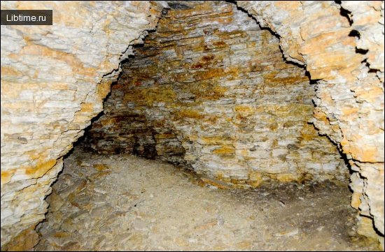
Large grottoes and long, wide galleries characterise the Red Cave, some resembling an underground canyon eroded by water along a huge fissure. The biggest grottoes formed where the floors of upper levels collapsed in zones of intense tectonic fracturing. One example is the Fifth Collapse Grotto, which ends the main passage of the Red Cave: it is about 80 m long and 30 m wide and is strewn with giant limestone blocks. The Hall of the Blue Drop is also striking, reaching a height of 60 metres.
What is the underground river of the Red Cave like?
An underground river flows along the bottom of the Red Cave for almost its entire length, forming a chain of flowing lakes in the low-water period up to 100 m long, 5–8 m wide and 2–4 m deep. This river is the hydrological heart of the system and shapes much of its mineral decoration.
The average annual discharge of the underground river is 0.1 m³/sec. Its low-water discharge does not exceed 7–8 l/sec, but in spring during snowmelt it increases almost 750 times, and the water level in some grottoes rises by 8–10 m above the low-water mark.
Karst springs on the tuff site, located 17 m below the entrance to the Dark Cave, track the river's changing flow. In autumn there are only five downward springs on the site, while in spring there are 30, including seven griffins — upward-flowing springs. The water of the underground river has a carbonate-chloride-calcium-sodium composition with a mineralisation of 320–360 mg/l, and its temperature varies through the year from 9.2 to 9.8°.
The Red Cave River begins as the Subotkhan River, which disappears into the Proval Mine in the southern part of the Dolgorukovsky Massif, 5 km in a straight line from the cave entrance. From the Proval Mine a wide inclined gallery, washed along a sandstone bed between two limestone slabs and totalling 1,265 metres, runs toward the Red Cave; 1,700 m in a straight line separate the gallery's end from the Fifth Collapse Grotto.
Additional water reaches the Red Cave River from the western basin of the Dolgorukovsky plateau, where the large Averkiev Mine descends 145 m with 405 m of horizontal-inclined passages. Lateral tributaries, such as the Overhanging Vaults gallery, drain the Bezarobinskaya Basin to the north. Fluorescein staining showed that water travels from the Proval Mine to the tuff site, where the river surfaces, in 39 days during low water and less than two days during high water.
What formations and decorations does the Red Cave contain?
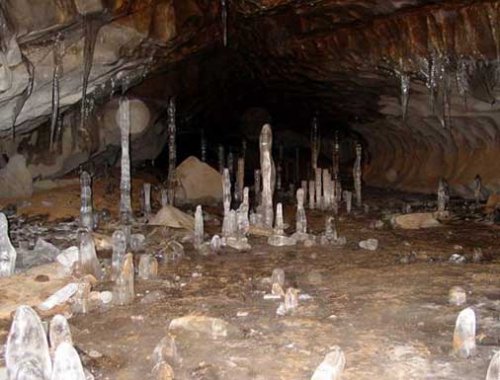
The air temperature inside the Red Cave ranges from 9.8 to 11.6°, though some entrance galleries reach 18° in summer and drop to −5° in winter, when garlands of ice stalactites form on their arches.

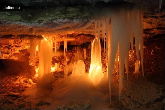
Calcite cascades 2–8 m high are among the most distinctive features, located behind the Stalactite (Fifth) Siphon. They recur roughly every 60 m, a regularity broken only in zones of intense tectonic fracturing, and form through the precipitation of calcium carbonate as the temperature of the underground flow changes. A total of 36 cascades were recorded in this part of the Red Cave.
Rarer mineral features add scientific interest to the Red Cave. Moon milk was found in the gallery of Overhanging Vaults, while original gypsum flowers grow on the surface of limestone blocks in one of the galleries near the First Siphon.
What fossils and archaeology have been found in the Red Cave?
Paleontological finds in the Red Cave include bones of a cave bear, hare, hamster, alpine jackdaw and tussock, recording the fauna of the surrounding region across the cave's long history.
Archaeological remains of the Kizil-Kobin culture, dating to the Late Bronze Age and the beginning of the Iron Age, were found on the tuff site at the entrance to the Red Cave. The Kizil-Kobins, who lived in the 7th–6th centuries BC, are according to some researchers descendants of the Cimmerians and ancestors of the Taurians, and they give the cave its alternative name, Kizil-Koba.