Pamir-Tanynan Speleological Country: Caves of Central Asia and the Gissar-Alai
 libre
libre
The Pamir-Tanynan speleological country spans the mountain systems of south-eastern and eastern Central Asia, encompassing some of the most rugged and least-explored karst terrain on the continent. Within its boundaries lie three distinct speleological areas — the Tanshan, the Gissar-Alai and the Pamir-Tajik — each defined by a different combination of rock type, tectonic history and elevation. The region overlaps the high ground of the Pamir Mountains, the great mountain hub that Central Asian geographers call the Pamir Knot.
Where is the Pamir-Tanynan speleological country located?
The Pamir-Tanynan speleological country occupies the south-east and east of Central Asia, straddling the elevated belt where several of Asia's largest ranges converge. Its caves are scattered across foothills, ridges and high plateaus, with individual cavities recorded from a few hundred metres above river level up to altitudes of 4,400 m on the Pamir Plateau. The three speleological areas — Tanshan, Gissar-Alai and Pamir-Tajik — together hold more than 200 documented caves and mines.

Countries and regions spanning the Pamir-Tanynan system
The Pamir-Tanynan system reaches across the borders of several modern Central Asian states. The Pamir Mountains themselves are centred on Tajikistan, where the high-altitude caves fall largely within Gorno-Badakhshan Autonomous Oblast (GBAO), and extend into Kyrgyzstan, China, Afghanistan and Pakistan. The Pamir Knot is the tectonic junction where the Pamirs meet the Hindu Kush, the Karakoram (Karakorum Mountains), the Tien Shan (Tian Shan) and the Kunlun (Kunlun Mountains), linking northward toward the Altai and eastward toward the Himalaya. This convergence of ranges — sometimes described together with the Himalayas as the "roof of the world" — gives the speleological country its enormous range of elevations and rock formations.
Geological and tectonic setting
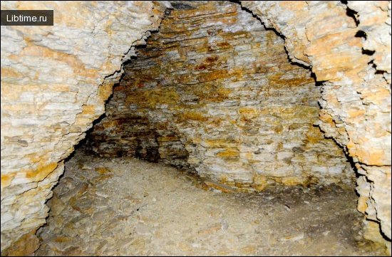
The caves of the Pamir-Tanynan country were carved into rocks laid down across hundreds of millions of years and later uplifted by the same collision that built the Pamir Knot. Cavities are confined chiefly to carbonate rocks of the Paleozoic, Mesozoic and Paleogene, together with halogenic (salt-bearing) formations of the Upper Jurassic. Intense tectonic fracturing, driven by the ongoing convergence of crustal plates beneath Central Asia, controls the orientation and shape of most passages — many caves follow tectonic cracks rather than simple bedding planes.
Carbonate and halogenic rock formations
Two rock families dominate cave formation across the region. Carbonate rocks — Paleozoic limestones in the Osh Mountains, Jurassic limestones in the Zeravshan-Gissar province — dissolve slowly under percolating water to produce classic karst galleries and decorated grottoes. Halogenic formations, principally Upper Jurassic salt, behave very differently: at the Khoja-Mumyn salt dome a stream actively carves a corridor through blocks of rock salt, an unusually fast and dynamic form of cave development. The contrast between durable limestone karst and rapidly evolving salt karst is one of the defining features of the speleological country.
Speleological areas within the country
The Pamir-Tanynan country is divided into three speleological areas of very uneven exploration. The Tanshan area in the north is barely studied, the Gissar-Alai area in the centre holds the great majority of described caves, and the Pamir-Tajik area in the south-east contains both the salt caves of the Tajik lowlands and the extreme high-altitude cavities of the Pamir Plateau.
Tanshan speleological area
The Tanshan speleological area is the least researched of the three, with only about 60 caves known to date. Survey work here has lagged behind the better-developed Gissar-Alai region, leaving much of the karst potential unrecorded.
Karasayskaya Cave
Karasayskaya is the largest known cave in the Tanshan area, located in the Karatau ridge and measuring 200 metres in length. It remains the principal reference cavity for a region whose full extent of underground development is still largely undocumented.
Gissar-Alai speleological area
The Gissar-Alai area is the speleological heart of the country, subdivided into two provinces: Turkestan-Alai and Zeravshan-Gissar. Together these provinces account for the majority of described caves, including the longest cavities in the entire system.
Turkestan-Alai Province
The Turkestan-Alai province covers the Turkestan and Alai mountain ranges along with their northern foothills, and 44 caves have been described within it. The most notable are Kan-i-Gut, Beshungur (315 m), Katranungur (157 m), Chilustun (140 m) and the Barite Cave (over 100 m). Several of these lie in the Osh Mountains, which are composed of Paleozoic limestone.
Kan-i-Gut Cave
Kan-i-Gut is the longest cave in the Turkestan-Alai province, with passages totalling some 3,000 metres. Its name, often rendered as the "mine of perdition," reflects a long history of human use and the labyrinthine reputation of its galleries, which combine natural karst with ancient workings.
Beshungur Cave
Beshungur Cave sits on the north-western slope of the Chil-Mayram ridge, 14 km west of Osh city, and is in fact a cluster of five connected caves. A narrow entrance roughly 1 × 1.5 m, confined to a tectonic crack, opens into a cone-shaped well that widens at a depth of 10 m to form a platform up to 7 m long. From this platform five wells descend, some opening into grottoes adorned with well-developed natelic formations. The total length of the system is 315 metres.
Chilustun Cave
Chilustun Cave lies about 3 km north-east of Aravan and consists of two halls linked by passages. The larger hall measures 89 m long, 30 m wide and 3 m high, and the cave is richly decorated with calcite deposits throughout. Its total surveyed length is 140 m.
Barite Cave
The Barite Cave is one of the more mineralogically distinctive cavities of the region, set in the northern foothills of the Alai Range along the middle reaches of the Aravan River. Its ceiling and walls are coated with both calcite and barite crystals, giving it its name. The cave extends for more than 100 metres.
Zeravshan-Gissar Province
The Zeravshan-Gissar province takes in the Zeravshan, Gissar and Karategin ranges, including the south-western spurs of the Gissar Range that swing from a latitudinal to a south-westerly direction west of the Gava Pass and branch into a series of ridges. Caves are widespread here, confined to Paleozoic, Mesozoic and Paleogene carbonate rocks as well as Upper Jurassic halogenic formations. In total, 85 caves and mines have been described within the province, among them Kapkotan (6,000 m), Karluk (1,050 m), Yakkabag (600 m) and Amir-Temir (350 m).
Kapkotan Cave
Kapkotan Cave is excavated in Jurassic limestones, and its overall structure is governed by tectonic fracturing. Gypsum and calcite formations are widespread through its passages, and the air temperature inside holds steady around 20 °C. With a total length of roughly 6,000 metres, Kapkotan is the longest cave in the Zeravshan-Gissar province.
Karluk Cave
Karluk ranks among the major caves of the Zeravshan-Gissar province, with passages extending about 1,050 metres. Like its neighbour Kapkotan, it is developed in the carbonate and gypsum-bearing rocks that make this province so prolific, its layout shaped by the same network of tectonic fractures.
Yakkabag Cave
Yakkabag Cave lies on the right bank of the Kala River, a left tributary of the Kyzildarya, about 8 km south of Tashkurgan, and is developed in Upper Jurassic limestones. The entrance opens 150 metres above the river, leading to several grottoes; the largest reaches 100 m in length, 20 m in width and 30 m in height. In the far part of the cave lies a lake measuring 30 m by 14 m. The passages are decorated with calcitic concretionary formations — stalactites, helictites and stalagmites — and the total length of the cave is about 600 metres.
Amir-Temir Cave
Amir-Temir Cave occupies the southern slope of the Karatube Ridge within the Amir-Temir intrusive massif, which contains lenses of limestone conglomerate. The cave formed through the leaching of layers of crystalline bituminous limestone enclosed within a thickness of granite, producing galleries arranged on three levels. The height difference between the upper and lower levels reaches 45 metres, and the interior holds concretionary stalactites and small stalagmites. The total length is 350 metres.
Komsomolskaya Mine: deepest karst cavity
The Komsomolskaya mine is the deepest karst cavity in the mountainous part of Central Asia. Located on the Amankutan plateau, it forms a system of vertical passages reaching a total depth of 81 metres. As a predominantly vertical cavity, it stands apart from the long horizontal galleries that characterise most of the region's caves and represents the lower limit of explored karst depth in these mountains.
Pamir-Tajik speleological area
The Pamir-Tajik area divides into two provinces — West-Tajik and Pamir — that contrast sharply in rock type and elevation. The West-Tajik province corresponds to the West Tajik depression, or Tajik lowlands, where about 20 small caves have been explored. The largest, Khoja-Mumyn, lies on the north-eastern slope of the Khoja-Mumyn salt dome at 300–400 m above the Yakhsu River. It takes the form of a corridor up to 8 m wide and high, along whose floor a stream of 15–20 l/sec runs noisily between debris and blocks of salt; the cave is 350 m long.

The Pamir province covers the high Pamir Plateau in the south-east of Central Asia, the loftiest mountain rise in the region, where karst caves remain extremely poorly studied. The most interesting is the Rangkul cave in the Salaktash gorge, at an absolute altitude of 4,400 m. It comprises four grottoes connected by wide, high passages; the total length is about 320 m, and the far part descends 100 m below the entrance. Adjoining this country to the north, the caves of the Turgai-Kazakhstan speleological country — covering Turgai and Central Kazakhstan — are also barely studied, the best known being the Konuraulie cave on the right bank of the Shagan River, formed in marbleized limestone and 120 m long.
Cave formations and mineral deposits
The decorated interiors of the Pamir-Tanynan caves owe their variety to the differing chemistry of the rocks they occupy. Limestone caves such as Chilustun and Yakkabag are rich in calcite formations, the salt and gypsum settings produce their own distinctive crystals, and the Barite Cave is unusual for its coating of barite. These mineral deposits are both the scientific interest and the visual appeal of the region's underground galleries.
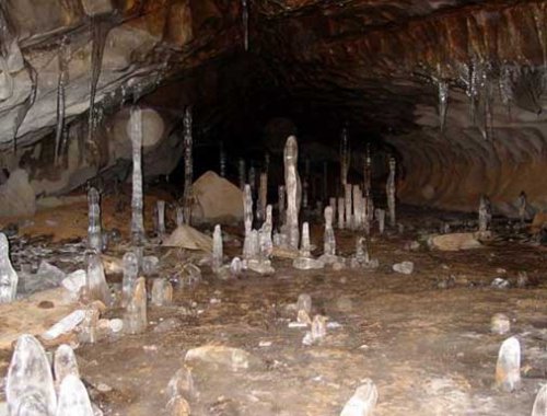
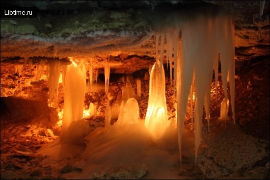
Stalactites, stalagmites and helictites
The most familiar speleothems in these caves are stalactites, stalagmites and helictites, formed as mineral-laden water drips and seeps through limestone. Yakkabag Cave displays all three, while Amir-Temir contains stalactites alongside notably small stalagmites. Helictites — the twisting, gravity-defying formations that branch in irregular directions — are among the more delicate and prized features, recorded in the calcitic grottoes of the Zeravshan-Gissar province.
Calcite, gypsum and barite crystals
Three crystal types characterise the mineral deposits of the region. Calcite is the most widespread, decorating limestone caves throughout the Gissar-Alai area. Gypsum dominates in caves such as Kapkotan, where it forms alongside calcite in Jurassic limestones. Barite, far rarer, lines the ceiling and walls of the Barite Cave on the Aravan River, making that cavity a distinctive mineralogical site within the whole speleological country.
Climate and microclimate of the caves
Cave interiors in the Pamir-Tanynan country maintain stable, sheltered conditions that contrast strongly with the harsh surface climate of Central Asia. Kapkotan, for example, holds a steady air temperature of around 20 °C regardless of the season outside. This thermal stability — a general property of deep karst — preserves delicate formations and supports specialised cave environments, while the surrounding mountains experience extreme swings between hot summers and bitterly cold winters governed by continental air masses, the westerly jet stream and the distant influence of monsoon dynamics.
Flora and vegetation of surrounding zones
The vegetation above the caves changes dramatically with altitude, forming distinct zones from foothill steppe to high-alpine desert. Lower slopes around the Osh Mountains and the Aravan River support steppe grasses and scattered shrubs adapted to dry summers, while precipitation patterns shaped by the westerlies allow richer meadow communities at mid-elevations used as summer pasture. On the high Pamir Plateau, where the Rangkul cave sits at 4,400 m, vegetation thins to sparse cushion plants and cold-tolerant species able to survive the short growing season and intense radiation of the high mountains.
Environmental change and climate impacts in Central Asia
Climate change is reshaping the high mountains that host the Pamir-Tanynan caves, most visibly through the retreat of glaciers that feed the region's rivers. The Pamirs hold some of the largest non-polar ice masses on Earth, including the Fedchenko Glacier and the Vanch-Yakh Glacier, and meltwater from these and neighbouring ranges sustains the Amu Darya and the streams that carve cave systems such as Khoja-Mumyn. Monitoring this ice has become a priority for international science, because changes here ripple downstream across all of Central Asia.
International research teams have used the high Pamirs to reconstruct past climate from glacier ice. Programmes such as the Central Asia Deep Ice-Coring Project — involving scientists including Vladimir Aizen, Susan Kaspari, Arzhan Surazakov, Dan Joswiak and Bjorn Gringholm, working through institutions such as the Climate Change Institute, the University of Maine, the University of Idaho, the University of Heidelberg, Nagoya University, the China Meteorological Administration and the Tajik Academy of Science — have applied ice-core drilling, snow-pit sampling and snowfield sublimation studies to build paleoclimate and Holocene climate records from these high elevations. Meteorological stations installed near Moskvina Base Camp, below Ismoil Somoni Peak (the former Samoni Peak), have extended that monitoring into real time. This work underlines the scientific value of the Pamirs as an archive of paleoclimatology and ice-age history.
Ecotourism and adventure trekking opportunities
The same mountains that contain the caves have become a growing destination for sustainable, community-based tourism. Tajikistan markets the Pamirs — and especially Gorno-Badakhshan (GBAO) and the Wakhan Corridor — as a frontier for adventure trekking, glacier travel and cultural exploration. The Pamir Eco-Cultural Tourism Association (PECTA) works to develop this sector responsibly, and the wider region's tourism credentials were recognised at the ITB Berlin 2018 Sustainable Top 100 Destination Awards. The landscape also includes major natural features such as Karakul Lake, Lake Sarez (impounded behind the natural Uzoi Dam), Lake Zorkul and the high summits of Muztagh Ata, Kongur Tagh and Ismoil Somoni Peak.
Ecotourism here is closely tied to poverty alleviation and local development. Organisations such as the Aga Khan Foundation and the Mountain Societies Development Support Programme (MSDSP) have supported skill-building, homestay enterprises — often run by women — and village tourism infrastructure that channel income directly into mountain communities. Tajik National Park, inscribed as a UNESCO World Heritage site for its outstanding glaciers, peaks and geological processes, protects much of this terrain, while the State Agency of Natural Protected Areas oversees conservation. The park's wildlife, including the snow leopard, the Marco Polo argali sheep and the Siberian ibex, is a draw for trekkers and wildlife photographers alike, and conservation of these endangered species is a central aim of the park's management plans.
Cave exploration safety and equipment
Exploring the caves and high mountains of the Pamir-Tanynan country demands careful preparation, because many cavities involve vertical wells and high-altitude approaches. Key safety considerations include:
- Acclimatization — staged ascent and rest days are essential before working at altitudes such as the 4,400 m Rangkul cave, to avoid altitude sickness.
- Vertical equipment — caves like Beshungur and the 81 m Komsomolskaya mine require ropes, harnesses and descent gear for their well systems.
- Glacier and crevasse skills — approaches across ice fields demand crevasse-rescue training and roped glacier-travel technique.
- Expedition logistics — remote high-altitude fieldwork relies on base camps such as Moskvina Base Camp, reliable supply lines and emergency communication.
- Local guides — engaging trained guides through bodies like PECTA improves both safety and community benefit.
For broader trip-planning context, the wider Travel and Speleology sections collect related guides and field reports.
Research history and speleological studies
The scientific record of the Pamir-Tanynan caves is highly uneven, reflecting decades of focused survey in some provinces and near-total neglect in others. The Zeravshan-Gissar province, with 85 documented caves and mines, and the Turkestan-Alai province, with 44, are comparatively well mapped, whereas the Tanshan area (about 60 caves) and the high Pamir province remain barely touched. The numbering of cave systems, recorded lengths and depths — from the 6,000 m Kapkotan to the 81 m Komsomolskaya mine — derive from systematic regional speleological surveys that catalogued cavities by province, rock type and morphology. Continued exploration, particularly on the high Pamir Plateau, is likely to reveal far more karst than is presently known.