Karlyuk Cave: Exploring the Stunning Gypsum Caves of Turkmenistan's Kugitang-Tau Ridge
 libre
libre
Karluk Cave is the largest karst cave in Turkmenistan, set into the southwestern slope of the Kugitang-Tau (Koytendag) ridge about 7 km east of the village of Karluk. It formed in Upper Jurassic limestones threaded with gypsum veins, and its surveyed passages run more than 1,000 metres past stalactite-hung grottoes, deep wells, and gypsum crystals. The sections below cover where it sits, how it formed, its chambers and speleothems, its scale and climate, and what a visit involves.

Karluk Cave Overview
Karluk Cave is a dry, horizontally developed karst cavity in eastern Turkmenistan, prized by speleologists for its scale and its rich gypsum and calcite decoration. The cave sits within the Koytendag region, a limestone massif on the border with Uzbekistan that holds one of Central Asia's densest concentrations of caves. Karluk is the best known of these, often grouped with neighbouring systems such as Kap-Kutan Cave, Hashimeyuk Cave, and Tashyurek Cave.
The name appears in several spellings — Karluk, Karlyuk, and Garlyk — all referring to the same cave and the nearby settlement of Garlyk in the Magdanly area. Its combination of large galleries, towering stalagmites, and transparent gypsum crystals makes it a centrepiece of the Koytendag's speleological heritage.
Location and How to Get There
Karluk Cave lies 7 km east of the village of Karluk, on the southwestern flank of the Kugitang-Tau ridge in eastern Turkmenistan. The ridge — known locally as Koytendag — forms part of the southwestern spur of the Pamir-Tian Shan mountain belt and rises along Turkmenistan's eastern frontier. Reaching the cave means travelling first to the Magdanly or Garlyk area in the Lebap region, then continuing by road toward the ridge before the final approach on foot.
Because the cave sits in a remote, protected mountain zone, most visitors arrive as part of organised Turkmenistan travel packages that combine the Koytendag caves with the region's other draws, such as the dinosaur trackway plateau and the Akhal Teke horse country further west. Independent access is difficult, and the surrounding area requires permits.
Geographic Setting in the Kugitang-Tau Ridge
The Kugitang-Tau ridge is a limestone and gypsum highland at the western edge of Eurasia's great mountain knot, where the Pamir and Tian Shan systems meet. Its steep slopes, deep canyons, and soluble rock have produced classic karst topography: sinkholes, dry valleys, and an extensive underground drainage network. Karluk Cave is one expression of this landscape, developed where groundwater exploited fractures in the bedrock over geological time.
Cave Formation and Geology
Karluk Cave formed through the slow dissolution of soluble rock by water, the defining process of all karst caves. The host rock is Upper Jurassic limestone, laid down in shallow seas more than 145 million years ago, later uplifted and fractured as the surrounding mountains rose. Mildly acidic groundwater moving along those fractures gradually widened them into the passages and chambers seen today.
Upper Jurassic Limestone and Gypsum Veins
The limestone enclosing Karluk Cave is penetrated by veins of gypsum up to 0.2 m wide. This pairing of carbonate rock and sulphate mineralisation is central to the cave's character: limestone dissolves to feed calcite formations, while the gypsum veins supply the material for the cave's striking transparent crystals and selenite concretions. The interplay of the two minerals gives Karluk a more varied mineral palette than caves cut into limestone alone.
Tectonic Fissures and Cave Development
The cave's main gallery follows a tectonic fissure running in a northeasterly direction, a fracture opened by the same mountain-building stresses that raised the Kugitang-Tau ridge. Such fissures act as plumbing for groundwater, guiding the flow that excavates a cave and dictating the orientation of its largest passages. The linear, corridor-like form of Karluk's principal gallery directly reflects this structural control.
Cave Structure and Layout
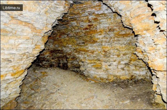
Karluk Cave is organised around a single dominant gallery off which open a series of grottoes, wells, and vertical voids. The floor throughout is dry, strewn with fallen limestone blocks and coated in a layer of fine dusty clay. This arrangement — one main corridor branching into decorated chambers — is typical of fissure-guided karst systems.
The Main Gallery and Entrance
The entrance to Karluk Cave is a narrow slit roughly 0.5 m high and about 3 m wide, an unassuming opening that gives no hint of the scale within. It leads directly into the main gallery, a wide and high passage confined to the northeast-trending tectonic fissure. This gallery is the structural spine of the cave, from which the larger grottoes branch.
Grottoes Inside the Cave
Several grottoes open off the main gallery, each a widened chamber where dissolution and collapse have enlarged the original fissure. These grottoes hold the bulk of the cave's speleothems and account for its reputation as one of the most ornately decorated caves in the Koytendag.
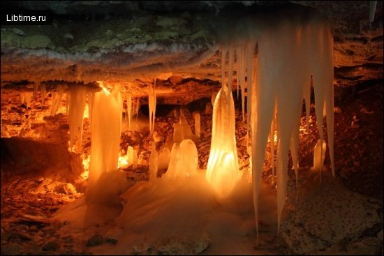
The Stalactite Grotto
The Stalactite Grotto is the largest chamber in Karluk Cave, reaching 190 metres in length and 10 metres in height. Its name reflects the abundance of carbonate formations hanging from and rising within it. As the single biggest void in the system, it is the showpiece of any survey or guided descent into the cave.
Wells and Organ Pipes
The cave contains deep wells and organ pipes — vertical features that add a third dimension to its otherwise horizontal layout. Wells are shafts dropping below the passage floor, while organ pipes are tubular voids dissolved upward into the ceiling, often clustered in rows. Both demand caution and proper equipment, as they create sudden drops and overhead hazards within the chambers.
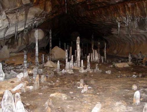
Speleothems and Mineral Formations
Karluk Cave is adorned with calcite and gypsum concretionary formations, the product of its mixed carbonate-and-sulphate geology. Mineral-laden water seeping through the rock deposits its dissolved load drop by drop, building the dripstone and crystal features that decorate the chambers over tens of thousands of years.
Calcite and Gypsum Concretions
Concretionary formations of both calcite and gypsum line the walls and floors of Karluk Cave. Calcite, precipitated from dissolving limestone, forms the classic white-to-amber dripstone, while gypsum, derived from the cave's mineral veins, produces softer, sometimes glassy growths. The coexistence of both minerals is what sets Karluk apart from purely calcareous caves.
Stalagmites and Gypsum Crystals
Stalagmites in Karluk Cave reach up to 6 m in height and 1 m in diameter, ranking among the most imposing in the region. Equally notable are the large transparent crystals of gypsum, prized by mineralogists for their clarity and size. Together these features make the cave a natural showcase of how a single system can grow both massive carbonate columns and delicate translucent sulphate crystals.
Cave System Statistics and Scale
The surveyed (filmed) portion of Karluk Cave extends 1,050 metres, though the system is widely regarded as larger than the mapped section alone. Key measured features give a sense of its scale:
- Surveyed length: 1,050 metres of mapped passage.
- Largest chamber: the Stalactite Grotto, 190 m long and 10 m high.
- Tallest stalagmites: up to 6 m high and 1 m in diameter.
- Gypsum veins: up to 0.2 m wide within the host limestone.
- Entrance: a slit roughly 0.5 m high and 3 m wide.
Microclimate and Air Temperature
The air temperature recorded inside Karluk Cave was 20°C, notably warm for a cave at this latitude and a reflection of the surrounding region's hot climate and the cave's depth and ventilation. A stable, relatively warm interior air mass distinguishes Karluk from the cool, near-constant chill of many limestone caves elsewhere. Visitors should still expect humidity and uneven footing across the clay-dusted floor.
Cave Exploration History and Timeline
Systematic exploration of Karluk Cave belongs to the broader speleological investigation of the Koytendag massif, which intensified through the second half of the twentieth century. Survey teams mapped its main gallery, the Stalactite Grotto, and the network of wells and organ pipes, ultimately documenting 1,050 metres of passage. The cave was studied alongside its neighbours — Kap-Kutan Cave, Hashimeyuk Cave, and others — as part of an effort to chart the region's interconnected karst systems.
Detailed cave documentation is ongoing, since soluble karst landscapes continually reveal new passages as exploration equipment and techniques improve. Ground-penetrating radar and modern surveying now supplement traditional mapping in karst regions worldwide, helping researchers trace voids that lie beyond the reach of direct access.
Archaeological Significance
The Koytendag caves, including Karluk, carry archaeological and palaeontological interest alongside their geological value. The wider region is famous for fossil evidence of past life — most spectacularly the dinosaur trackways preserved on the nearby plateau — and the cool, sheltered interiors of caves have long offered refuge to people and animals. While Karluk Cave is celebrated chiefly for its mineral formations, the surrounding karst landscape forms a continuous record of the region's deep natural and human history.
Cave Conservation and Fragility
Karluk Cave's speleothems are fragile and effectively irreplaceable, growing back only over geological timescales if broken or soiled. The transparent gypsum crystals and tall stalagmites are especially vulnerable to handling, careless lighting, and the residue left by unmanaged visitors. Protecting them depends on controlled access, designated routes, and a strict policy of touching nothing and removing nothing.
The cave's place within a recognised protected mountain zone supports these safeguards. Conservation of karst features worldwide increasingly stresses limiting visitor numbers and educating those who enter, so that the formations that took millennia to grow survive for future study and admiration.
Place in the Pamir-Tian Shan Speleological Region
Karluk Cave is part of the Pamir-Tian Shan speleological country, the vast karst province spanning the mountain belt where the Pamir and Tian Shan ranges meet across Central Asia. This classification groups Karluk with the many caves of the Koytendag and beyond into a single speleological framework defined by shared geology and cave-forming conditions. Within that province, the Koytendag caves are among the most significant, and Karluk ranks as a flagship example.
Wildlife and Bird Watching Opportunities
The slopes and canyons around Karluk Cave support the wildlife of the Koytendag highlands, making the approach itself rewarding for nature watchers. Cave entrances across the region shelter bats, while the surrounding cliffs and gorges attract birds of prey and other species adapted to arid mountain terrain. Travellers exploring the area often combine caving with wildlife observation across the broader ridge.
Visiting Karluk Cave: Practical Tips
Visiting Karluk Cave calls for preparation, a guide, and respect for its fragility. The cave lies in a remote, protected part of eastern Turkmenistan, so plan around organised access rather than spontaneous arrival. Practical pointers for a visit include:
- Go with a guide: the wells and organ pipes create real fall and overhead hazards that demand local knowledge and proper equipment.
- Bring caving basics: a reliable headlamp, sturdy footwear for the clay-coated, block-strewn floor, and backup lighting.
- Expect warmth and humidity: interior air around 20°C means layering should account for exertion rather than cold.
- Leave no trace: do not touch crystals or formations, and carry out everything you bring in.
- Arrange permits in advance: the protected mountain zone requires documentation, usually handled through a tour operator.
For more on caves and underground exploration, browse our speleology articles, or plan wider journeys through the travel section.