Karst Caves of Crimea: Exploring a Hidden Underground World
 libre
libre
The caves of Crimea are a network of more than 700 karst caves, mines, and wells concentrated in the mountainous part of the Crimean Peninsula, ranging from short grottoes to the 13-kilometre Red Cave. They form part of the Crimean-Caucasian speleological country, which is divided into two regions: the Crimean region and the Greater Caucasus.

Geographic and Geological Setting
Crimea's caves are concentrated in the high limestone plateaus of the Main Ridge of the Crimean Mountains, a belt that runs parallel to the Black Sea coast above resort towns such as Yalta, Alushta, and Simferopol. The peninsula's karst country is among the most thoroughly explored in the region, with hundreds of documented underground forms packed into a relatively compact mountain zone.
Crimean-Caucasian Speleological Country
The Crimean-Caucasian speleological country is a single geological grouping split into two regions: the Crimean region and the Greater Caucasus. The Crimean region encompasses the mountainous part of Crimea and is represented by the province of Mountain Crimea, while the Caucasus region extends across southern Russia into the Krasnodar Territory. This pairing links Crimea's caves to a broader belt of karst that includes some of the deepest and longest cave systems in this part of Europe.
Mountain Crimea Province and the Yayla Ranges
Mountain Crimea is characterised by the wide distribution of karst caves, mines, and wells developed across the high tablelands known as the Yayla. The word yayla comes from the Turkic language and means "summer mountain pasture," reflecting the traditional use of these flat upland surfaces for grazing. The principal plateaus include Chatyr-Dag, Ai-Petri, and Karabi-Yayla, each a broad limestone surface riddled with sinkholes and cave entrances. More than 700 underground karst forms have been studied in Mountain Crimea, among them 53 caves longer than 100 metres and 18 natural mines deeper than 100 metres.
Karst Formation in Upper Jurassic Carbonate Rocks
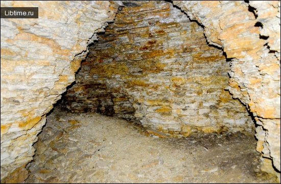
The caves of Crimea formed within carbonate rocks of the Upper Jurassic that make up the structure of the Main Ridge of the Crimean Mountains. Over millions of years, rainwater and snowmelt charged with carbon dioxide seeped into joints in this limestone, slowly dissolving the rock to open shafts, galleries, and chambers. The result is a classic karst landscape in which surface water disappears underground and re-emerges lower down as springs, leaving the plateaus dry on top and hollow beneath.
Marble Limestone Composition and Cave Origin
The marble-like limestone of the Crimean plateaus is the raw material from which the most spectacular caves were carved. Where the Upper Jurassic carbonate is dense and crystalline, dissolution produces smooth, polished walls and richly decorated chambers — the quality that gives Marble Cave on Chatyr-Dag its name. As water percolates through these marbled limestones, it deposits calcite drop by drop, building the stalactites, stalagmites, columns, and flowstone curtains that make the equipped Crimean caves famous.
Cave Classification and Naming
Crimean caves are classified by their form and origin into horizontal caves, vertical mines and wells, and combined systems, and they are named largely from the Turkic toponymy of the peninsula's earlier inhabitants. Many names describe a cave's appearance, colour, or a local legend rather than its scientific properties, so place names such as Kizil-Koba ("red cave") and Suuk-Koba ("cold cave") double as plain descriptions.
Color Symbolism in Crimean Cave Names
Colour words run through Crimean geography and carry both literal and directional meaning in the Turkic naming tradition. Kizil ("red") in Kizil-Koba refers to the iron-stained clay that tints the cave's lower passages, while colour terms elsewhere on the peninsula — black, white, and red — were also used in older Turkic systems to mark compass directions. This layering of literal colour and symbolic direction explains why so many Crimean rivers, rocks, and caves carry a colour in their names.
Major Caves of Crimea
The most significant caves of Crimea stand out by length and depth, with the longest reaching 13,100 metres and the deepest mines plunging well over 100 metres. The headline systems include Red Cave, Uzundzhinskaya (1,500 m), Emine-Bair (1,158 m long and 125 m deep), Dzhur-Dzhur (750 m), Skelskaya (570 m), Ayanskaya (550 m), Yeni-Sala III (410 m), Hanging (401 m), Snake (310 m), Egiz-Tinakh I (255 m), and Mangupskaya (230 m). Several of these are equipped with paths and lighting for visitors, while others remain the preserve of trained cavers.
Red Cave (Kizil-Koba)
Red Cave, known in Turkic as Kizil-Koba, is the longest cave in Crimea at 13,100 metres and one of the most important in this part of Europe. It is a multi-level system on the western slope of the Dolgorukovskaya Yayla, carved on several tiers through which an underground river still flows, feeding the Kizilkobinka stream at the surface. The cave takes its name from the red iron-bearing clays that stain its galleries, and its deeper sections require diving and technical caving to reach.
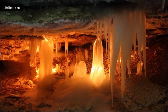
Marble Cave: Location and Geography
Marble Cave (Mramornaya) lies on the lower plateau of Chatyr-Dag in the Crimean Mountains, near the village of Perevalnoyeh, around 17 kilometres from Simferopol and within easy reach of Alushta and the Black Sea coast. It sits at roughly 920 metres above sea level and is widely regarded as one of the most beautiful equipped caves in Europe. Discovered in 1987 by the Simferopol speleology team, Marble Cave was opened to visitors and is now managed by the Onyx-tour center, which maintains its paths, lighting, and guided routes.
Cave Halls and Galleries
Marble Cave is laid out as a sequence of named halls and galleries connected by concrete sightseeing paths. Its showpieces include the Gallery of Fairy Tales, where calcite formations resemble figures and scenes, and the Perestroika Hall — one of the largest equipped cave chambers in Europe, measuring roughly 100 metres long with a ceiling that rises many metres overhead. The route runs past forests of stalactites and stalagmites, flowstone draperies, and rimstone pools, with several tour options ranging from a short standard walk to longer excursions into the lower galleries for more experienced visitors. The acoustics of the larger halls are good enough that cave concerts have been staged underground.
Emine-Bair-Khosar Cave
Emine-Bair-Khosar, also written Emineh-Bair-Khosar, is a deep multi-level cave on the same Chatyr-Dag plateau as Marble Cave, measuring 1,158 metres long and 125 metres deep. Entered through a natural vertical shaft, it is celebrated for its colossal chambers and for the fossilised bones of Ice Age animals — including mammoth remains — recovered from its floor, which give one of its sections the nickname of a natural museum. Like Marble Cave it is fitted with paths and lighting and managed by the Onyx-tour center, with a sequence of routes suited to different levels of fitness.
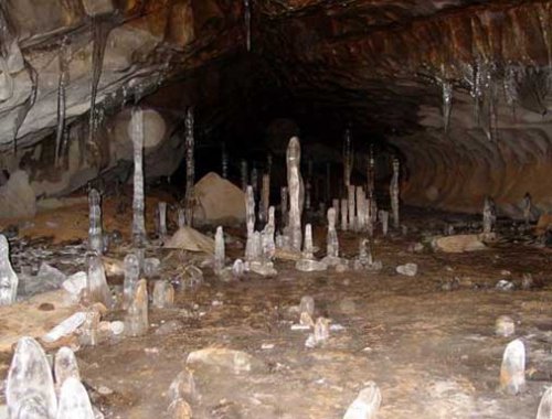
Buzluk Ice Cave
Buzluk cave is an ancient ice cave on the Karabi-Yayla plateau, famous for the permanent ice that forms inside it even through the Crimean summer. Cold air sinks into its entrance shaft in winter and is trapped below, so columns and sheets of ice persist year-round in the lower chamber. Buzluk is a wild, unequipped cave that draws cave-exploration enthusiasts rather than casual tourists, and reaching it involves a hike across the remote Karabi tableland.
Other Notable Caves and Mines
Beyond the equipped show caves, Mountain Crimea holds a long list of caves and natural mines that matter chiefly to science and sport. Suuk-Koba ("cold cave") and Bin Bash-Koba ("thousand-head cave") on Chatyr-Dag, Soldatska cave — among the deepest in Crimea — and Studentska cave on Karabi-Yayla are repeatedly explored and surveyed by speleological expeditions. These systems, together with the dozens of shafts deeper than 100 metres, make the Crimean plateaus a year-round training ground for cavers.
European Cave Rankings
Crimea's equipped caves rank among the finest in Europe, and Marble Cave is consistently named in international listings of the continent's most impressive show caves. Marble Cave and Emine-Bair-Khosar are presented through the International Association of Equipped Caves framework that profiles developed caves worldwide, and the Perestroika Hall is cited as one of the largest equipped underground chambers on the continent. This standing places Crimea alongside the well-known karst destinations of southern Europe as a recognised speleotourism region.
Cave Discovery and Exploration History
The systematic exploration of Crimea's caves accelerated through the twentieth century as organised speleology took hold on the peninsula. Marble Cave was discovered in 1987 by the Simferopol speleology team, who then championed its careful opening to the public rather than leaving it to deteriorate. Generations of expeditions have surveyed the long systems of the Yayla, mapping passages, measuring depths, and pushing into flooded sections by cave diving where dry caving cannot continue.
Archaeological Discoveries and Research
Crimean caves preserve a record of both deep prehistory and human occupation, making them important archaeological sites as well as natural wonders. The Ice Age bone beds of Emine-Bair-Khosar yielded remains of mammoth and other extinct fauna, while caves and rock shelters across the mountains contain traces of prehistoric cave dwellings. Scientific documentation of these finds — paleontological, archaeological, and geological — continues to draw researchers, and the caves' formations are studied to reconstruct the region's climate history.
Cave Towns of Crimea
The "cave towns" of Crimea are medieval settlements cut into the soft limestone cliffs of the peninsula's inner ridge, distinct from the natural karst caves of the Yayla. Clustered around Bakhchisaray, sites such as Eski-Kermen and Mangup-Kale combine carved chambers, churches, and defensive works hollowed from the rock with masonry fortifications built on top. They are among the most striking cultural heritage attractions in Crimea.
Cave Towns: Definition and Characteristics
Cave towns are fortified plateau settlements in which much of the architecture — dwellings, storerooms, cisterns, chapels, and defensive casemates — was excavated directly into the rock. Their builders chose flat-topped limestone outcrops with sheer cliffs on most sides, adding walls and gates only where the natural defences were weak. This urban planning made the most of the terrain: spatial organisation followed the shape of the plateau, with religious structures, monastery cells, and burial caves carved alongside ordinary homes.
Eski-Kermen Settlement History and Architecture
Eski-Kermen is one of the best-preserved cave towns of Crimea, a fortified settlement founded in the early medieval period on a steep-sided limestone massif near Bakhchisaray. Its inhabitants carved hundreds of chambers into the cliffs — houses, granaries, churches with painted walls, and a remarkable rock-cut defensive complex — while a siege well and gatehouses controlled access to the plateau. Eski-Kermen flourished as a regional centre before its fortifications were dismantled and the town declined following raids during the era of Khan Nogai.
Crimean Gothia and Byzantine-Gothic Relations
Crimean Gothia was a medieval polity in the mountainous south-west of the peninsula whose population descended in part from the Goths who settled the region in late antiquity. It developed in close federative alliance with the Byzantine Empire, which valued the mountain Goths as a buffer against the Khazars and other steppe powers, and the church figure St. John of Gothia became a focus of local Christian identity. Out of this Byzantine-Gothic world grew the Theodoro Principality, a Christian state centred on Mangup-Kale that survived until the Ottoman Empire conquered it in 1475, ending independent rule in mountain Crimea after earlier pressure from the Mongols. Mangup-Kale itself preserves the citadel, churches, and rock-cut chambers of this lost principality, while later figures such as Bohdan Khmelnytsky belong to the wider history of the lands around the Black Sea.
Nature and Environment
The cave country of Crimea sits within a mosaic of mountain forests, high pastures, and protected reserves that shelter rich and sometimes rare wildlife. The same karst that hollows the plateaus shapes the surface ecology, controlling where water flows, where soils form, and where the meadows give way to bare limestone.
Flora and Fauna of the Crimean Mountains
The Crimean Mountains support a distinctive flora and fauna adapted to limestone soils and a Mediterranean-influenced climate, with many species listed in the Red Data Book of Russia. Pine and beech forests clothe the slopes, while bats roost in the caves and birds of prey nest on the cliffs of the Yayla. Wildlife and bird watching are rewarding across the range, and several cave-dwelling and endemic species make the karst zone a focus for conservation biology.
Alpine Meadows and Mountain Pastures
The flat tops of the Yayla are covered by alpine-style meadows and mountain pastures that have been grazed for centuries, the very pastures that gave the plateaus their Turkic name. On Karabi-Yayla and Chatyr-Dag these treeless grasslands burst into wildflowers in late spring and early summer, then dry to gold as the season advances, creating seasonal colour changes that reward repeat visits. The meadows sit directly above the cave systems, and their sinkhole-pitted surface betrays the hollow limestone beneath.
Crimean Rivers and Underground Water Sources
Crimea's mountain rivers are fed largely by water that has passed underground through the karst, emerging at the foot of the plateaus as karst springs. The underground river inside Red Cave is the clearest example, surfacing as the Kizilkobinka and supplying streams that water the valleys below. Because so much of the rainfall sinks into the limestone before reappearing, the caves are an integral part of the peninsula's water supply as well as objects of cave-diving exploration where their passages flood.
Protected Reserves and Conservation
Many of Crimea's natural landscapes are safeguarded within a network of reserves managed under the Crimean Protected Areas system, which links cave conservation to wider habitat protection. The Yalta Mountain-Forest Nature Reserve protects forested slopes above the southern coast, while coastal and steppe reserves elsewhere on the peninsula — among them the Kazantyp Nature Reserve, the Opuksky Nature Reserve with its pink Lake Koyashskoye, the Lebyazhyi Islands Nature Reserve, the Karkinitsky Refuge, and the Small Phyllophora Field Refuge — shelter wetlands, birds, and rare marine plant communities around the Bay of Arabat and beyond. Together these reserves manage the balance between heritage preservation and growing tourism.
Visiting Crimean Caves
Visiting Crimea's equipped caves is straightforward, with guided tours, prepared paths, and visitor facilities at the main show caves on Chatyr-Dag. Marble Cave and Emine-Bair-Khosar are the most accessible, run by the Onyx-tour center with several route options, while wild caves like Buzluk require self-reliant hiking and proper caving experience.
Cave Accessibility and Tour Routes
The show caves offer a choice of guided routes graded by length and difficulty, from a short standard walk to extended excursions deeper into the galleries. At Marble Cave visitors can pick the main sightseeing circuit or longer routes into the lower halls, and tours run on a regular schedule during working hours through the season. Guides accompany every group, both to interpret the formations and to protect the cave; tickets and passes are bought at the cave entrance, and online booking and digital services are available through tour operators for those planning ahead.
Cave Infrastructure and Sightseeing Paths
Inside the equipped caves, concrete sightseeing paths, handrails, and electric lighting installations make the underground galleries safe and easy to walk while protecting the formations from damage. The lighting is arranged to pick out stalactites, stalagmites, columns, and coloured mineral incrustations along the route. Temperatures underground stay cool and steady year-round — generally around 8–9°C — so warm clothing and non-slip footwear are recommended whatever the weather outside, and photography is usually permitted with conditions on flash and tripods set by the operator.
Environmental Education Programs
The managed caves double as outdoor classrooms, hosting environmental education programmes that explain karst processes, cave ecology, and conservation to visitors and school groups. Guided commentary covers how the caves formed, why their formations are fragile, and how the Yayla's water cycle connects the surface meadows to the galleries below. These programmes tie the speleotourism experience to a wider message about protecting the fragile underground environment.
Crimea Tourism Attractions Nearby
The caves of Chatyr-Dag sit within easy reach of Crimea's best-known attractions, making them an easy addition to a wider tour. Nearby highlights include the Ai-Petri Mountain plateau above Yalta, the Dzhur-Dzhur waterfall near Alushta, the volcanic Kara-Dag massif and the artists' village of Koktebel, the medieval port of Sudak, and the cave towns around Bakhchisaray. Hiking trails link the plateaus to these sights, so cave visits combine naturally with outdoor activities along the Black Sea coast, and our broader Travel section covers more destinations across the region.