Caves of Central Siberia: Khudugunskaya, Balaganskaya, and the Angaro-Lenskaya Province
 libre
libre
The Central Siberian speleological country is a vast karst and cave region of Eastern Siberia that spans the Middle Siberian Plateau, the North Siberian Lowland, and the Byranga Mountains, stretching across Krasnoyarsk Krai and neighbouring territories of the Russian Federation. It holds more than 80 documented caves, the longest cave systems in continental Russia, and a landscape that ranges from Arctic tundra to dense taiga. This page explains where the region lies, how its caves formed, which caves are most notable, and how cave diving, climate, biodiversity, and conservation shape the area today.

Central Siberian Speleological Country: Overview
The Central Siberian speleological country covers the central swath of Eastern Siberia between the Yenisei River and the Lena River, encompassing the Central Siberian Plateau and its bordering lowlands and mountains. Karst caves are most widely developed in the southern part of this territory, distinguished as the Angaro-Lenskaya speleological province within the larger Lena-Yenisei region. More than 80 caves have been identified across the area, formed chiefly in soluble Lower Cambrian limestones.
The region's significance comes from its scale and its remoteness. It is one of the least disturbed large landmasses on Earth, threaded by the Yenisei, Lena, Podkamennaya Tunguska (Stony Tunguska), and Bakhta rivers, and it preserves cave systems, taiga ecosystems, and archaeological sites that remain only partly explored. Speleology research here is conducted largely by Russian caving groups, and findings appear in outlets such as the Speleology literature and the Journal of Cave and Karst Studies.
Geographic Extent and Boundaries
The Central Siberian speleological country is bounded by the Yenisei River to the west and grades eastward toward the Lena River, occupying much of Krasnoyarsk Krai, the former Evenk Autonomous Okrug, and the Turukhansky District. Its three principal physiographic units are the Middle Siberian Plateau, the North Siberian Lowland, and the Byranga Mountains, each contributing distinct topography and terrain composition.
Middle Siberian Plateau
The Middle Siberian Plateau (Central Siberian Plateau) forms the structural core of the region and hosts most of its karst. This elevated tableland of trap basalts, sedimentary platforms, and incised river valleys sits between the Yenisei and Lena basins. Its limestone outcrops along the Angara and Ilim valleys are where the densest concentration of caves occurs, including the systems of the Angaro-Lenskaya province.
North Siberian Lowland
The North Siberian Lowland lies between the Middle Siberian Plateau and the Byranga Mountains, a broad subsidence belt of wetlands, floodplains, and permafrost terrain draining toward the Arctic. Its waterlogged plains and floodplain ecosystems connect the plateau's rivers to the Kara Sea and create the transitional zone where taiga gives way to tundra.
Byranga Mountains
The Byranga Mountains are the northernmost element of the region, a low Arctic range on the Taimyr Peninsula extending beyond the Arctic Circle. Glaciated, treeless, and bordering the Siberian Arctic, the Byranga range marks the cold extreme of the speleological country and lies within the protected lands managed in part by the Taimyrsky Nature Reserve.
Geological Formation and Karst Development
The caves of Central Siberia formed by the slow dissolution of carbonate rock along structural weaknesses, producing passages controlled by ancient tectonics rather than by surface streams alone. Karst studies in the region focus on how Lower Cambrian limestones, dolomites, and gypsum responded to fracturing and groundwater flow over hundreds of millions of years.
Limestone and Lower Cambrian Formations
Lower Cambrian limestones are the host rock for the majority of caves in the Angaro-Lenskaya province, including Khudugunskaya Cave. These marine carbonates, laid down more than 500 million years ago, are thick, widespread, and readily dissolved by slightly acidic groundwater, making them the foundation of the region's speleological wealth.
Tectonic Fractures and Cave Morphology
Cave morphology in Central Siberia is dictated by tectonic fractures of northwestern and northeastern extent, along which passages and grottoes developed as water exploited the broken rock. This structural control explains why caves such as Khudugunskaya consist of small grottoes linked by straight, long corridors radiating in fixed directions. Clastic cave deposits and sediments within these passages preserve a record of past climates, and cave sediment analysis — including magnetic dating work associated with researchers like Jaroslav Kadlec, Martin Chadima, and Helena Hercman — has been used to reconstruct the timing of cave development.
Speleological Provinces and Regions
The Central Siberian speleological country is subdivided into provinces and regions that group caves by geology and location, with the Angaro-Lenskaya province standing out as the most cave-rich. These divisions help speleologists organize exploration and compare cave-bearing terrains across the wider Lena-Yenisei region.
Angaro-Lenskaya Speleological Province
The Angaro-Lenskaya speleological province, lying in the southern part of the territory, contains the greatest concentration of caves in Central Siberia, with more than 80 identified. It takes its name from the Angara and Lena river systems and includes the region's longest and best-known caves, all developed in Lower Cambrian carbonates.
Lena-Yenisei Region
The Lena-Yenisei region is the broader speleological framework that encompasses the Angaro-Lenskaya province and extends across the interfluve between the Lena and Yenisei rivers. It links the southern karst belt to the cave-bearing rocks farther north and east, providing the geographic context in which individual provinces are classified.
Notable Caves of Central Siberia
The most significant caves of Central Siberia are Khudugunskaya, Balaganskaya, Bolshaya Nizhneudinskaya, Malaya Nizhneudinskaya, Botovskaya, and the Korshunikha natural mine, ranging from short grotto systems to the longest cave in Russia. They illustrate the variety of Siberian cave characteristics and challenges, from horizontal river-valley caves to deep vertical shafts.
Khudugunskaya Cave
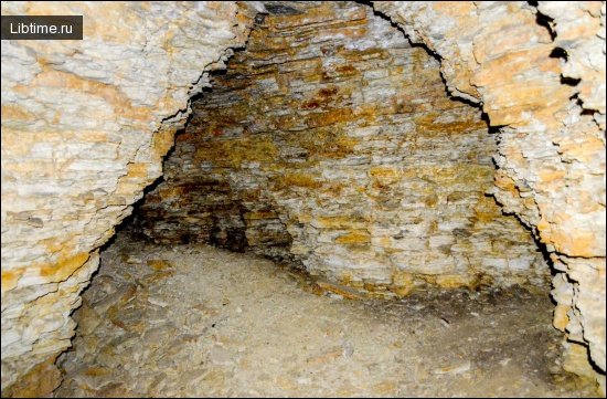
Khudugunskaya Cave, on the left bank of the Angara River near the town of Cheremkhovo, is one of the longest caves in the region at 3,000 metres. Formed in Lower Cambrian limestones, it has several small grottoes from which straight, long corridors run off in different directions. All its passages and grottoes are confined to tectonic fractures of northwestern and northeastern extent, giving the cave its angular, fracture-guided plan.
Balaganskaya Cave
Balaganskaya Cave is a notable system roughly 1,200 metres long, developed like its neighbours in the carbonate rocks of the Angara basin. Its size places it among the larger explored caves of the Angaro-Lenskaya province, second only to Khudugunskaya among the classic group.
Bolshaya and Malaya Nizhneudinskaya Caves
The Bolshaya Nizhneudinskaya and Malaya Nizhneudinskaya caves are a paired system near Nizhneudinsk, measuring about 550 metres and 160 metres respectively. The "great" and "lesser" caves share the same limestone host and have long attracted attention for their accessibility and their archaeological and palaeontological interest.
Botovskaya Cave
Botovskaya Cave is the longest cave in Russia and the centrepiece of Eastern Siberian speleology, with explored passages exceeding 60 kilometres in a dense, maze-like network. The geology of Botovskaya Cave is a thin, near-horizontal bed of Ordovician–Cambrian limestone capped and floored by sandstone, which has confined dissolution to a single stratigraphic layer and produced an unusually flat, two-dimensional labyrinth. Its clastic sediments have been the subject of international cave science, with palaeomagnetic and luminescence studies contributing to the wider literature on Siberian cave development.
Korshunikha Natural Mine
The Korshunikha natural mine, located in the valley of the Korshunikha River within the Ilim River basin, is a striking vertical cavity reaching a depth of 133 metres. Unlike the horizontal corridor caves of the Angara valley, this natural shaft demonstrates the deep karst potential of the region and the role of vertical fracturing in cave formation.
Eastern Siberia Cave Systems
Eastern Siberia's cave systems are characterized by extreme length, cold and stable internal climates, and great distance from settlement, which together make them some of the most logistically demanding caves on Earth. Botovskaya Cave exemplifies the type — vast horizontal mazes in flat-lying limestone — while shorter caves like the Nizhneudinskaya pair and vertical features like Korshunikha round out the diversity. Exploring these caves means contending with permafrost, ice, long approach marches, and the absence of any nearby rescue infrastructure, so expeditions are typically mounted by experienced clubs working over weeks at a time.
Cave Exploration and Diving
Cave exploration in Central Siberia combines traditional dry caving with technical cave diving, the latter required wherever flooded passages or sumps block the way forward. Cave diving is among the most hazardous forms of exploration, demanding specialised training, redundant equipment, and meticulous planning, and in Siberia it is compounded by near-freezing water.
Diving Expedition Planning and Objectives
Diving expedition planning in remote Siberian caves begins long before anyone enters the water, with objectives that usually center on pushing known sumps, surveying flooded galleries, and recovering scientific samples. Planning covers transport of gas and gear over great distances, staged supply caches, fixed timelines, surface support, and clearly defined turnaround rules. Because evacuation may take days, expeditions set conservative goals and treat every dive as self-rescuing.
Cave Diving Exploration Techniques
Cave diving exploration relies on a continuous guideline laid from open water into the cave, allowing divers to retrace their route in zero visibility. Core techniques include line-laying and referencing, strict gas-management rules such as the rule of thirds, careful buoyancy and trim to avoid stirring sediment, and methodical survey of newly found passage. Teams move slowly, place directional markers, and document each push so that subsequent dives build on a known map.
Equipment and Gas Mixtures for Extreme Diving
Equipment for extreme cave diving uses fully redundant systems and tailored gas mixtures so that any single failure is survivable. Typical configurations include twin cylinders or sidemount tanks with independent regulators, multiple lights, and dive computers, plus the following considerations:
- Breathing gases: nitrox for shallower work, trimix (oxygen, helium, nitrogen) for deep dives to limit narcosis and oxygen toxicity.
- Decompression gas: oxygen-rich mixes carried as stage cylinders for staged ascents.
- Thermal protection: drysuits with heated undergarments for prolonged immersion in near-freezing water.
- Redundancy: at least two independent gas sources, two cutting tools, and backup lights on every dive.
Cold Water Diving Physiology and Safety
Cold water diving in Siberian caves carries serious physiological risk, with hypothermia the foremost danger when water hovers near freezing. Heat loss accelerates with depth and time, impairing dexterity and judgement, so divers manage it through drysuits, heated layers, strictly limited bottom times, and constant monitoring of warmth and function. Decompression procedures for deep dives are followed precisely, since cold slows inert-gas elimination and raises decompression risk; staged ascents and conservative profiles reduce the chance of decompression sickness. Hypothermia prevention also depends on a warm surface camp where divers can rewarm immediately after exiting the water.
Climate and Environmental Conditions
Central Siberia has one of the most severe continental climates on Earth, with bitterly cold winters, short cool summers, and widespread permafrost that shapes every ecosystem. These conditions govern cave temperatures, river regimes, and the distribution of forest and tundra across the region.
Climate Classification and Weather Patterns
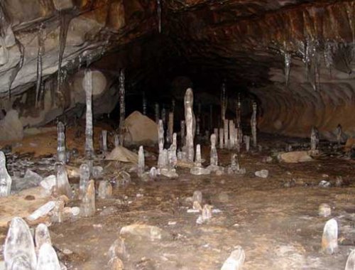
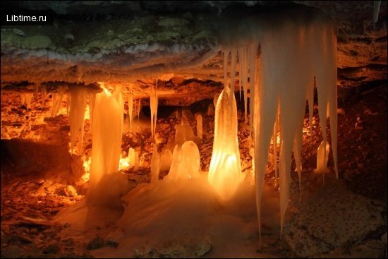
The region's climate is classified as subarctic continental (and Arctic in the far north), marked by extreme annual temperature ranges, low precipitation, and long, dark winters. Winter temperatures routinely fall below minus 40 °C across the Central Siberian Plateau, while brief summers can be warm; permafrost underlies most of the territory. These weather patterns keep many caves at constant near-freezing temperatures and lock the lowlands in ice and snow for much of the year.
Ecoregion Characteristics
The dominant ecoregion is the East Siberian taiga, the world's largest expanse of boreal forest, grading into Arctic tundra in the north. Forests are dominated by larch (Larix gmelini), which tolerates permafrost, alongside Siberian pine, Siberian spruce, and birch. This taiga forest ecosystem, interlaced with wetlands, bogs, and floodplains, defines the surface above the region's caves and sustains its wildlife.
Biodiversity and Biogeography
Central Siberia sits within the Palearctic realm and supports a characteristic boreal and Arctic biota, from large mammals of the taiga to specialised cave-dwelling invertebrates. Its biodiversity is studied across protected reserves and ecological stations and is notable for both its wilderness extent and its sensitivity to disturbance.
Biogeographical Significance
The region's biogeographical significance lies in its position as a vast, continuous block of Palearctic boreal habitat spanning the boundary between taiga and Arctic tundra. The Yenisei valley functions as a recognized faunal and floral divide — the basis of the Johansen Line — separating western and eastern Siberian species assemblages, which makes the area important for understanding species distribution across northern Eurasia. Long-term study at the Yenisei Ecological Station Mirnoe has documented these gradients in flora, mammals, fish, and butterfly and insect fauna.
Cave Fauna and Invertebrate Life
Cave fauna in Central Siberia consists mainly of cold-adapted invertebrates living in the stable, dark, near-freezing interiors of the caves. Because surface conditions are so harsh and the caves so cold, the subterranean fauna is sparse and specialised, and remains incompletely catalogued — one reason ongoing speleology research and cave science here continue to yield new records.
Conservation and Protection Status
Large parts of Central Siberia are protected within federal reserves classified by the IUCN, yet the region faces real threats from industrial development and the legacy of Soviet-era exploitation. Conservation here balances the preservation of near-pristine wilderness against pressure for resource extraction.
The Central Siberian State Nature Biosphere Reserve — also rendered as the Central-Siberian Nature Reserve or Central Siberia Nature Reserve — was established in 1985 under the U.S.S.R. and is administered today by Russia's Ministry of Natural Resources and Environment from Moscow. It is a zapovednik (strict nature reserve, broadly IUCN category I), protecting a representative cross-section of the East Siberian taiga along the Yenisei, together with the associated Game Park Yeloguisky wildlife refuge. Neighbouring protected areas in the wider Krasnoyarsk Krai network include the Putoransky, Taimyrsky, Bolshoi Arktichesky, Stolby, Sayano-Shushensky reserves, reflecting a broad programme of nature reserve establishment in Central Siberia.
Environmental Threats to Central Siberia
The gravest environmental threats to Central Siberia stem from resource development, above all the Norilsk Industrial Complex, whose smelting of nickel and other metals has produced severe air pollution and acid deposition damaging surrounding taiga and tundra. This human-nature conflict in resource development is intensified by logging, mining, and infrastructure, set against the post-World War II ecological degradation rooted in Stalin's nature-transformation ideology and the Soviet drive to industrialize the Arctic regardless of ecological cost.
Biodiversity Conservation in the Arctic
Biodiversity conservation in the Siberian Arctic centres on safeguarding the circumpolar wilderness and the species that depend on it, from reindeer and Arctic fox to migratory birds, within reserves such as Taimyrsky and Bolshoi Arktichesky. These wilderness and ecotourism values in circumpolar regions are weighed against the history of indigenous peoples — including the Kets and Evenk communities — whose traditional ecological knowledge and land interests are increasingly recognized in management. Arctic conservation also confronts the long shadow of the Soviet GULAG labor camps and mining operations documented in Aleksandr Solzhenitsyn's The Gulag Archipelago, which left enduring scars on the northern landscape.
Wilderness Preservation Collaboration
Effective wilderness preservation in Central Siberia depends on collaboration among Russian reserve authorities, scientists, and international partners. Cooperative work has linked Russian researchers with institutions such as the U.S. Department of Agriculture Forest Service and its Rocky Mountain Research Station, drawing on figures associated with regional environmental science like Andrei P. Laletin, alongside the indigenous Kets and Evenk peoples whose stewardship is central to long-term protection. Such partnerships gained momentum during the Gorbachev-era environmental policy reforms of perestroyka, when Mikhail Gorbachev's government opened space for civil environmental initiatives.
Research and Scientific Infrastructure
Scientific research in Central Siberia is anchored by long-running ecological stations and reserve field bases that support the study of taiga ecology, climate, and biodiversity. These facilities offer scientific research opportunities to Russian and international teams and underpin much of what is known about the region.
Ecological Stations
The Yenisei Ecological Station Mirnoe, on the Yenisei near Bor in the Turukhansky District, is the principal long-term research base of the region, conducting decades of monitoring of taiga and floodplain ecosystems along the river. Stations like Mirnoe, together with the headquarters of the Central Siberian State Nature Biosphere Reserve, provide the infrastructure for water-basin management studies, faunal surveys, and the biogeographical work associated with the Yenisei divide.
Ancient Observatories and Historical Sites
Southern Siberia, particularly the Khakassia region around Abakan, Shira, and Tuim near the Kuznetsk Alatau, is rich in archaeological heritage including Stone Age settlements, ancient observatory-like megalithic sites, and burial complexes that record the long presence of Homo sapiens in the area. The dramatic Tuim subsidence — a flooded former copper mine whose collapse formed a deep circular pit and underground lake — has become a magnet for cave diving exploration of underwater mining artifacts and structures, and ranks among the region's most distinctive geological and historical attractions. These sites tie the speleology of Central Siberia to a deeper human story stretching from Stone Age artifacts through Russian colonial settlement of Siberia from the 16th century onward.
For more guides on caves, karst, and underground exploration, browse the Speleology section, and explore related Travel and Astronomy articles across the site.