Caves of the Caucasus Mountains: A Guide to the World's Deepest Cave Systems
 libre
libre
Veryovkina Cave: The World's Deepest Cave
Veryovkina Cave is the deepest known cave on Earth, with a surveyed depth of 2,212 meters from its entrance to its terminal siphon. It lies in the Arabika Massif of the Western Caucasus, within the Gagra district of Abkhazia, a disputed territory on the Black Sea coast that Georgia regards as part of its own land. Explored primarily by the Perovo-Speleo team of Moscow cavers, Veryovkina overtook the nearby Krubera-Voronja Cave in 2018 to claim the world depth record, making the Arabika Massif home to the two deepest caves ever mapped.
For speleologists, Veryovkina represents the frontier of human reach beneath the surface — a vertical world of shafts, flooded passages and underground rivers that takes expedition teams days to descend and ascend. The story of the cave spans more than four decades of exploration, a near-fatal flood, a tragic death, and the ongoing search for the bottom of one of the planet's last unexplored frontiers. This guide collects what is known about its location, geology, depth, history and the equipment needed to enter it.

Location and Cave Entrance
The entrance to Veryovkina Cave sits in the Arabika Massif, a high limestone plateau in the Gagra Range of the Greater Caucasus Mountain Range. The massif rises above the Black Sea coast in Abkhazia, a breakaway region whose status remains contested between Abkhazia and Georgia. The cave mouth opens at an altitude of roughly 2,285 meters above sea level, in a karst landscape of bare limestone, sinkholes and alpine meadows shared with the famous Krubera Cave.
Reaching the entrance is itself part of the expedition. Teams travel through the Gagra Mountains on foot, carrying gear to a remote camp on the massif before the descent even begins. The surrounding geopolitical context shapes access: because Abkhazia is recognized internationally by only a handful of states and claimed by Georgia, foreign cavers must navigate a complicated permissions environment to work in the region.
Coordinates and Mapping Information
Veryovkina Cave's entrance is located at approximately 43.41° N, 40.36° E in the Arabika Massif. Speleologists record cave entrances using several coordinate notations so that the same point can be relocated by any team. The most common are decimal degrees (DD), degrees-minutes-seconds (DMS) and the Universal Transverse Mercator (UTM) grid, each describing the same surface position in a different format.
- Decimal degrees (DD): a single number per axis, e.g. 43.41, 40.36 — the format used by most mapping apps and services such as LatLong.net.
- Degrees, minutes, seconds (DMS): subdivides each degree into 60 minutes and each minute into 60 seconds, the traditional notation on topographic maps.
- UTM: projects coordinates onto a metric grid of zones, useful for measuring on-the-ground distances during a survey.
Converting between these formats is routine for expedition planners, because handheld GPS units, national maps and published cave surveys do not always agree on a single notation. Accurate entrance coordinates matter for emergencies as much as for navigation, since a precise fix lets rescue teams locate the right shaft on a plateau pocked with hundreds of similar openings.
Gorno-Kolkhid Speleological Province Context
Within the caving area of the Greater Caucasus there are three provinces: North Caucasian, East Caucasian and Gorno-Kolkhid. The North Caucasus Speleological Province is located on the northern slope of the Greater Caucasus between the upper reaches of the Pshekha River (left tributary of the Belaya River) and the middle reaches of the Ardon River (left tributary of the Terek River). The Arabika Massif and Veryovkina Cave belong to the western edge of this karst belt, where the same Jurassic and Cretaceous limestones that host the record-breaking caves continue along the range.
Cave Depth and Dimensions
Veryovkina Cave reaches a measured depth of 2,212 meters, making it the deepest cave known on Earth. The system descends through a sequence of vertical shafts and steep meanders before opening into larger horizontal galleries at depth, ending in a terminal siphon — a fully water-filled passage that marks the current explored limit. The vertical drop is equivalent to stacking more than six Eiffel Towers end to end below the entrance.
The cave's profile is dominated by deep pits in its upper section, where cavers rig ropes down a near-continuous series of drops. Lower down, the passages broaden into chambers large enough to hold underground camps, and an active stream gathers into an underground river that flows toward the siphon at the bottom. The terminal siphon and the underground lakes near it represent the deepest standing water yet reached on the planet by cavers.
Comparison with Other World's Deepest Caves
Veryovkina holds the depth record only narrowly over its neighbor Krubera-Voronja Cave, and both eclipse the next-deepest systems by a clear margin. The table below compares the deepest caves and shows how closely the top two are matched, both lying within the same Arabika Massif.
| Cave | Region | Depth |
|---|---|---|
| Veryovkina Cave | Arabika Massif, Abkhazia / Georgia | 2,212 m |
| Krubera-Voronja Cave | Arabika Massif, Abkhazia / Georgia | 2,197 m |
| Sarma Cave | Arabika Massif | ~1,830 m |
| Snezhnaja Cave | Western Caucasus | ~1,760 m |
Because Krubera Cave and Veryovkina Cave sit so close together in the same massif and trade the record by only metres, surveyors continue to re-measure both as new passages are pushed. Georgia's deepest caves ranking is therefore led by these two Arabika systems, with Sarma Cave and Snezhnaja Cave following — a concentration of extreme depth found nowhere else on Earth.
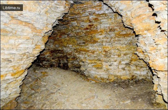
Cave Geology and Formation Features
Veryovkina Cave formed within the thick Cretaceous and Jurassic limestones of the Arabika Massif, dissolved over millions of years by water moving through the karst. The Arabika Massif itself was uplifted by the collision of the Arabian Plate with the Eurasian Plate, the same tectonic forces that raised the Greater Caucasus. Mountain-building that began around the Miocene Epoch lifted ancient sea-floor limestone high above the Black Sea, setting the stage for one of the deepest karst systems on the planet.
Karst caves confined to Jurassic gypsum and limestone are quite widespread across the Caucasus. The Arabika Massif acts as a giant karst aquifer: rain and snowmelt sink through the limestone and travel underground for kilometres before resurging at springs near the coast. Underground water tracing using dyes has shown that water entering high on the massif emerges far below at sea level, confirming the enormous vertical scale of its drainage and helping explain why caves here reach record depths.
Cave Passage Navigation and Climbing
Navigating Veryovkina demands almost continuous vertical work, with cavers rigging and descending rope on dozens of shafts in the upper cave before reaching the deeper galleries. The passages alternate between tight, water-worn meanders and large open pits, requiring teams to climb, traverse and rig anchors as they progress. Each metre of depth must be both descended on the way down and ascended on the way out, so navigation is planned around fixed rope rigging that stays in place for the length of an expedition.
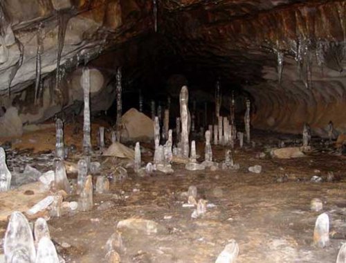
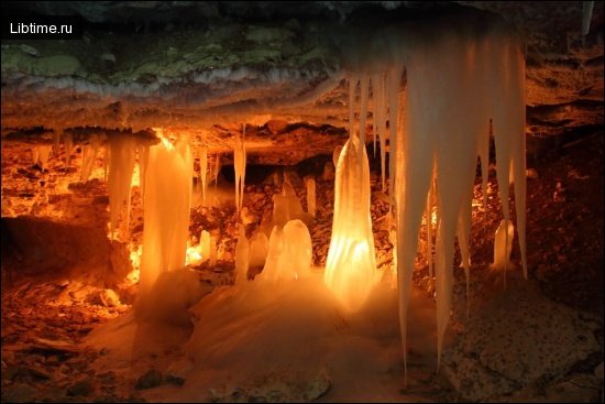
Nate formations — flowstone, stalactites and calcite crusts — decorate many chambers, but the dominant features for navigation are the shafts and the active stream. Lower passages carry running water, and at the bottom the stream becomes an underground river leading to the terminal siphon.
Cave Diving and Sump Exploration
Pushing past Veryovkina's terminal siphon requires cave diving, because the passage is completely flooded and cannot be passed on foot. Sump exploration involves divers carrying breathing gear through water-filled tunnels to search for continuing dry passage beyond, a discipline that combines the hazards of deep caving with those of technical diving. The terminal siphon and underground lakes at the bottom of Veryovkina are among the most remote dive sites on Earth, reachable only after a multi-day descent.
Siphon diving in deep caves is far more committing than the open-water diving done at sites like the Florida natural springs, because divers must first descend two kilometres of vertical cave before they can even enter the water, with no possibility of a fast exit. This combination of depth, remoteness and cold makes sump work at the bottom of Veryovkina one of the most demanding undertakings in exploration.
Cave Discovery History
Veryovkina Cave was first discovered in 1968 by Krasnoyarsk cavers, who descended its initial shafts to a depth of about 115 meters before exploration stalled for decades. The narrow, blocked passages near the entrance hid the immense system below, and for many years the cave was regarded as a minor pit. Only when later teams broke through the constrictions did the true scale of Veryovkina begin to emerge, transforming it from an overlooked shaft into the deepest cave on the planet.
Cave Naming and Nomenclature
The cave is named after Aleksandr Veryovkin, a Russian cave explorer whose surname is also transliterated as Alexander Verëvkin. Early survey notes referred to the cave by a code designation before it took the explorer's name, a common practice in Soviet-era speleology where cavities were first catalogued by number. Today the form "Veryovkina" is the standard English rendering, honoring the speleologist associated with the early Caucasus exploration effort.
Exploration History and Expedition Timeline
After its 1968 discovery, Veryovkina's depth grew in surges as successive teams forced the passages deeper over half a century. Krasnoyarsk cavers opened the cave in the late 1960s; later the Perovo-Speleo Club of Moscow cavers took up the exploration and, through a long campaign of widening squeezes and rigging new shafts, pushed the cave past one kilometre and then beyond two. In 2018 the Perovo-speleo team reached the terminal siphon at 2,212 meters, confirming Veryovkina as the world's deepest cave and surpassing the record long held by Krubera Cave.
- 1968: Krasnoyarsk cavers discover the entrance and descend to about 115 m.
- 1980s–2000s: Renewed exploration breaks through near-entrance constrictions, revealing deeper shafts.
- 2015–2017: The Perovo-Speleo team pushes the cave past 1,000 m and then beyond 2,000 m.
- 2018: Explorers reach the terminal siphon at 2,212 m, setting the world depth record.
The expeditions have also produced biological discoveries, including specimens of rare cave invertebrates collected at extreme depth. Endemic species described from the Arabika caves include the springtail Plutomurus ortobalaganensis, the beetle Duvalius abyssimus, the millipede Heterocaucaseuma deprofundum, and cave shrimp such as Xiphocaridinella demidovi — eyeless extremophile organisms adapted to total darkness that interest scientists studying life in hostile environments and even astrobiology.
Cave Camp System and Infrastructure
Exploring Veryovkina relies on a multi-camp system, because reaching the bottom and returning takes far longer than a single push allows. Expedition teams establish underground camps at intervals down the cave, stocked with sleeping gear, stoves, food and supplies so that cavers can rest, eat and stage further descents. These camps turn the cave into a vertical base of operations, letting a team live underground for a week or more while pushing the deepest passages.
Camp Establishment at Extreme Depths
The deepest camps in Veryovkina sit well over a kilometre below the surface, in chambers large enough to pitch tents on flat ground beside the underground stream. Establishing a camp at such depth requires hauling tents, sleeping mats, cooking equipment and many days of food down through the shafts in waterproof bags. Expedition logistics and food preparation are planned to the gram, since every item must be carried down by hand and carried back out, and a deep camp may shelter a team for the most critical and dangerous phase of the descent.
2018 Flood Incident and Rescue
In 2018 a team deep in Veryovkina was caught by a sudden flood pulse, a rapid rise in water that surged through the lower passages and forced an emergency escape. Flood pulses in cave systems are triggered when heavy rain or snowmelt on the surface drains quickly into the karst, sending a wall of water down passages that were dry hours earlier. The cavers had to climb fast through rising water, ascending ropes against the flow to reach higher chambers above the flood, an evacuation that ranks among the most dramatic survival episodes in deep caving.
Surviving a flood pulse depends on reading the warning signs and moving to high ground before passages fill, because a flooded shaft can become impassable in minutes. The 2018 incident drove later improvements in how the Perovo teams monitor weather, stage emergency gear and plan evacuation routes, part of the post-expedition learning that shapes every return to the cave.
2020 Death of Sergei Kozeev
In 2020 the caver Sergei Kozeev died during an expedition in Veryovkina Cave, a loss that underscored the lethal risks of exploring the world's deepest system. Deaths and accidents in deep cave exploration are rare but stark, because rescue from kilometres underground is slow, difficult and sometimes impossible, and a medical emergency that would be minor on the surface can prove fatal below. The death of Sergei Kozeev is remembered within the caving community as a sobering reminder of the price that frontier exploration can exact.
Caver Equipment and Safety Gear
Exploring Veryovkina requires a full suite of vertical caving and personal protective equipment, because the cave combines extreme depth, cold and water. The standard environmental conditions underground — temperatures only a few degrees above freezing, near-total humidity and constant darkness — make exposure and hypothermia constant threats. Personal protective equipment for cave diving and deep caving typically includes:
- Single rope technique (SRT) kit: harness, ascenders, descender and cowstails for rigging and climbing the shafts.
- Helmet with redundant lighting: primary and backup headlamps, since total darkness leaves no margin for light failure.
- Thermal and waterproof layers: oversuit, undersuit and gloves to fend off hypothermia in cold water and wet passages.
- Wetsuit or drysuit for diving: required to survive immersion at the terminal siphon and underground lakes.
- Camp and survival gear: tent, sleeping bag, stove and rations hauled to the deep camps.
Physical endurance is as critical as the gear, because ascending more than two kilometres of rope to exit the cave demands sustained strength over many hours. Risk assessment and disciplined decision-making govern every push: teams weigh weather, water levels and fatigue before committing to the deepest, most committing sections.
Cave Diving and Descending Techniques
Descending Veryovkina depends on single rope technique, in which each caver rappels down fixed ropes and later ascends the same ropes using mechanical clamps. Rope ascending through water adds a serious hazard, because climbing a rope under a waterfall or in a flooding shaft risks both hypothermia and drowning, and cavers must manage cold and exhaustion while making vertical progress. Hypothermia prevention — keeping moving, staying as dry as possible, and reaching warm camp before exhaustion sets in — is woven into every descending and climbing technique used in the cave.
Cave Photography and Documentation
Documenting Veryovkina is the work of specialist expedition photographers, most notably Robbie Shone, whose images of the cave for National Geographic brought the deepest cave on Earth to a global audience. Cave photography at this depth is extraordinarily difficult: photographers must carry fragile camera gear and powerful flashes through flooded squeezes and down kilometres of rope, then light vast black chambers that have never seen daylight. Working with teams such as BASE Studios, photographers including Robbie Shone produce the surveys, maps and imagery that turn an inaccessible system into something the public can see and scientists can study.
Beyond stills, documentation includes precise measurement and survey work, the speleology research methods that fix the cave's depth and shape on paper. Every chamber is measured, every shaft logged, and the results are compiled into the maps that establish Veryovkina's record depth and guide future expeditions.
Other Notable Caves of the Greater Caucasus
Veryovkina is the deepest of many remarkable caves in the Greater Caucasus, a range whose three speleological provinces together hold hundreds of explored cavities. The sections below survey the wider karst country around the record-holder, from the gypsum labyrinths of the north to the deep abysses of the Gorno-Kolkhid province that produced both Veryovkina and Krubera Cave.
North Caucasus Speleological Province
The North Caucasus Speleological Province lies on the northern slope of the Greater Caucasus, where karst caves confined to Jurassic gypsum and limestone are quite widespread. At present 142 caves have been described here, including 38 caves more than 100 m long. The largest are Butkova I (7000 m long), Dezova (473 m), Bagovskaya VI (1900 m), Beslineaevskaya I (1800 m), Ammonitnaya (1669 m), Azishskaya (1280 m) and Neizma (1235 m).
A special position is occupied by Butkova I cave (total length of about 7000 m), located 7 km south-east of Novosvobodnaya station. It was formed in limestones of Jurassic age. The cave is a complex labyrinth of narrow and low passages, passing in some places into small grottoes.
Among the caves of the Caucasus is interesting Azishskaya cave (total length 1280 m), located on the north-western slope of the Azish-Tau ridge, 12 km from the village of Khamyshki. It was formed in Upper Jurassic dolomitized limestones. The cave consists of several grottoes and passages connecting them. The largest grottoes reach 25 meters in length and 25 meters in height. A stream flows along the bottom of the main passage. Nate formations are widely developed. The air temperature is 10-12°.

East Caucasus Speleological Province
The East Caucasus Speleological Province is located in the northeastern part of the Greater Caucasus east of the Ardon River. There are 35 caves explored here. The largest of them are Nyvzhin-leget (350 m long), Chaldybalskaya (150 m), Kara-Budakhkentskaya (135 m) and Usman-leget (100 m). The cave Nyvzjin-leget is located on the interfluve of the rivers Fiogdon and Gizeldon, 3 km east of the village Tagardon, on the northern slope of the spur of Khosh-Khararog.
The cave was formed in limestone. The entrance reaches 1.8 m in height and 10 m in length. The length of the cave is 350 m and the volume is 1500 m3. The Gorno-Kolkhid speleological province, by contrast, is located on the southwestern slope of the Greater Caucasus, between the Sochi River and the Surama Ridge. It is characterized by a very wide distribution of karst caves, many of which reach significant sizes. At present, more than 420 karst cavities have been explored here, including 96 caves over 100 meters long and 10 mines deeper than 100 meters.
The largest caves in the Caucasus include the Vorontsov system (8000 m long), the Novoafon cave (3285 m long), Abrskila (2500 m long), Tkibula-Dzevrula (1800 m long, 280 m deep), Kelasurskaya (length 1380 m, depth 100 m), Taroklde (1370 m), Shakuranskaya III (1300 m), Bolshaya Akhunskaya (1200 m), Okrodzhanashvili (1150 m), Varsina (960 m), Sataplia (890 m) and Shvilobisa (860 m).
Vorontsov Cave System
The Vorontsovskayasystem includes mainly the caves Big Vorontsovskaya, Long and Labyrintovaya, located in the upper reaches of the Kudepsta River. The Big Vorontsovskaya Cave is a complex labyrinth of underground galleries and grottoes with a total length of 2218 meters. Half a kilometer north of it is the entrance to the Labyrinth Cave, confined to the north-western periclinal end of the Vorontsovskaya anticline, composed mainly of Upper Cretaceous limestone.
The cave is 1920 m long and consists of a series of passages and grottoes. In some of the grottoes there are wells up to 15 m deep. Streams flow along the bottom of many passages. There is a waterfall 2 m high. There are three siphons in the cave, which are passable in the dry season.
Fluorescein staining method established that water enters the cave from the Kudepsta River, which is absorbed by the ponor at the contact of Upper Cretaceous limestone and palogenic marl. From the Labyrinth Cave it enters the Big Vorontsovskaya Cave through cracks, which is also proved with the help of fluorescein.
The Dolgaya Cave (1560 m long) is located one kilometer east of Bolshaya Vorontsovskaya. Its entrance resembles a well, passing into a 20-meter long spiral descent that leads to horizontal galleries. A stream flows along the bottom of the cave, there are siphons.
Abrskila Cave (2500 m long), located on the western slope of one of the southern spurs of the Kodori Ridge, 28 m northeast of Ochamchire, also belongs to the large caves.

The deepest karst cavities of the region cluster in the Gorno-Kolkhid province. Among the historically famous deep systems are Snezhnaya (long surveyed at 770 m and now known to be far deeper), Geographic (510 m), Nazarovskaya (500 m), Oktyabrskaya (400 m), Velichivnaya (320 m) and Shkolnaya (300 m). There are five grottoes in the Snow Abyss; the largest, the Big Grotto, reaches 120 m in length and 70 m in width, with an ice hill 15 m high rising in its middle part.

In Snezhnaja Cave, Nate formations are especially beautiful in the Corallite well. In the Vertical Labyrinth, consisting of many passages developed along tectonic cracks, a stream appears that at first has an intermittent distribution. Below it turns into a significant flow of 20-30 l/sec, which in some places forms bizarre waterfalls up to 8 m high. At a depth of 700 meters, the Vodopadnoy stream flows into a large underground river whose flow rate reaches 500 liters/sec, rushing down a stepped passage 2-6 m wide before disappearing in a stone rubble.
Planning Your Visit and Adventure Travel
Veryovkina Cave is not a tourist destination — it is a serious expedition objective for trained vertical cavers, not a site casual adventure travellers can visit. The depth, cold water, flood risk and remote location of the Arabika Massif put the cave far beyond hiking or guided-tour caving, and any descent requires years of single rope technique experience, a capable team and careful permissions to work in Abkhazia. Those drawn to the wider region can still explore the Greater Caucasus through show caves and accessible karst, but the deepest passages remain the preserve of expedition speleology.
For armchair explorers and aspiring cavers alike, the appeal of Veryovkina lies in its status as one of the last unexplored frontiers on Earth, alongside the deep ocean and other planets. If you want to read more on caving and exploration, browse our Speleology articles, or plan a real-world trip through our Travel section and the wider library of articles about travel, nature, science and life.
Contact Information
For questions, corrections or contributions about Veryovkina Cave and Caucasus speleology, you can reach our editorial team through our Contact us page. Readers who want to know more about how we research and write our material can visit the About Libtime.com page, and common reader questions are gathered in our FAQ.