Kan-i-Gut Cave: A Karst Wonder of the Pamir-Tyan Shan Speleological Country
 libre
libre
Kan-i-Gut Cave: Overview
Kan-i-Gut Cave is a large karst and mining cave in southern Kyrgyzstan, located in the Shodymir tract on the Sary-Too massif of the Turkestan Range. It is a complex combination of spacious grottoes, vertical wells and winding corridors, formed first by water and later reshaped by centuries of ore mining.

The name Kan-i-Gut — sometimes written Kani-i-Gut — and its scale, dual karst-and-mining origin, and long human history set it apart from ordinary natural caves. It draws speleologists, historians and adventure travellers to the Batken Region, where it sits among a cluster of geological and paleontological landmarks.
Geographic Location and Coordinates
Kan-i-Gut Cave lies in the Batken District of the Batken Region in southwestern Kyrgyzstan, within the Sary-Too massif (also recorded as the Sary Too geological area) on the northern slopes of the Turkestan Range, part of the wider Tian-Shan mountain system. The cave opens in the arid foothills of the Shodymir tract, a dry, rocky landscape typical of this corner of Central Asia near the borders with Tajikistan and Uzbekistan.
The setting places Kan-i-Gut within easy reach of other Batken Region attractions, including the Madygen fossil locality and the associated Madigen Geopark. Its position in the Turkestan Range, on the edge of the Great Silk Road corridor, has shaped both its mining history and its modern appeal to geotourism in Kyrgyzstan.
How to Get to the Cave
Reaching Kan-i-Gut Cave usually begins from the regional centre of Batken, the administrative hub of the Batken Region, from where rough mountain tracks lead toward the Sary-Too massif and the Shodymir tract. Independent access is difficult, so most visitors travel with a local guide or a specialist operator such as GeoTours, which runs adventure expeditions to the cave and surrounding sights.
- Fly or drive to Batken, the nearest sizeable town.
- Continue by off-road vehicle toward the Sary-Too foothills.
- Complete the final approach on foot to the cave entrance in the Shodymir tract.
- Arrange a guide in advance — the terrain is remote and signposting is minimal.
Cave Dimensions and Layout
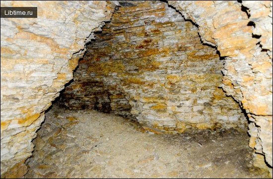
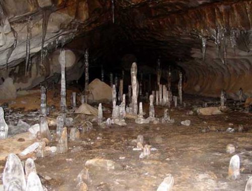
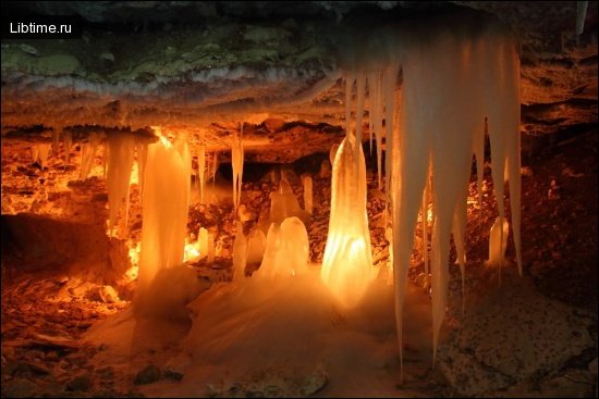
Kan-i-Gut Cave has a total length of about 3 kilometres and contains 18 grottoes linked by corridors and vertical shafts. The largest grottoes reach up to 50 metres in length and 45 metres in height, giving the interior the feel of underground halls rather than narrow passages. The entrance sits 18 metres below the cave's exit and 34 metres above its lowest point, so the system has significant vertical relief from end to end.
Grottoes, Wells and Corridors
The internal structure of Kan-i-Gut Cave alternates between broad chambers and tight, winding routes, a layout that reflects both natural dissolution and human excavation. Vertical wells connect different levels, and the largest grottoes form the cave's most impressive spaces.
- 18 grottoes, the biggest up to 50 m long and 45 m high.
- Vertical wells linking the upper and lower levels of the cave.
- Winding corridors that thread between the chambers.
- A through profile, with separate entrance and exit and a deep lowest point.
Climate Inside the Cave
The interior of Kan-i-Gut Cave is dry, with a stable air temperature of around 10°C year-round. The low humidity distinguishes it from many wet limestone caves and has helped preserve traces of old mine workings underground.
Geology and Cave Formation
Kan-i-Gut Cave is of karst origin, formed in limestone of the Turkestan Range, but its present shape owes as much to chemistry and mining as to simple water erosion. Two processes combined to create the cavity: the dissolution of limestone by groundwater, and the chemical breakdown of metal-bearing minerals concentrated in the rock.
Karst Origins
As a karst cave, Kan-i-Gut began as water streams dissolved soluble limestone along fractures in the Sary-Too massif. This natural dissolution opened the initial network of voids that later miners would follow and enlarge. The cave therefore belongs to the same family of dissolution caves studied across the Tian-Shan and beyond — a subject explored more broadly in Speleology.
Role of Sulfide Oxidation and Mining
Beyond ordinary karst, chemical reactions tied to the oxidation of sulfides played a major role in dissolving the limestone and shaping Kan-i-Gut Cave. The same sulfide minerals were rich in iron and lead-silver ores deposited by ancient water streams, which made the cave attractive to miners. Centuries of extraction then greatly altered the cave's natural configuration, carving the grottoes and corridors that visitors see today.

Etymology and Naming of Kan-i-Gut
The name Kan-i-Gut comes from local Persian-influenced terminology and is commonly translated as "mine of destruction" or "place of perdition", a reference to the dangers faced by those who once worked or were forced into its depths. The grim nickname reflects centuries of folklore about miners and captives who entered the cave and never returned.
Local Nomenclature and Meaning
Local nomenclature ties Kan-i-Gut to the nearby Fortress Kan, and the cave appears in records under spellings such as Kani-i-Gut Cave. The element "kan" denotes a mine or ore source, fitting a site defined by its mining past, while the wider name evokes the legends of loss attached to the underground labyrinth. These naming traditions preserve the memory of the cave's role as both a resource and a place of peril.
Mining History
Kan-i-Gut Cave was worked for metal ores over many centuries, with major activity dated roughly between the 6th and 11th centuries and successive periods of extraction by different civilizations. Mining transformed the natural karst cavity into an industrial-scale underground complex, leaving galleries, spoil and tool marks that researchers still study today.
Early and Arab Mining Periods
Early mining at Kan-i-Gut is associated with the Arabs, who exploited its silver and other metals during the medieval flourishing of Central Asian mining. The cave is linked in regional tradition to the great scholar Abu Ali ibn Sina — known in the West as Avicenna — reflecting how prominent the site was in the era's accounts of mineral wealth. These early periods established Kan-i-Gut as one of the region's most important sources of silver and lead.
Chinese Mining Activities
Chinese miners are also counted among the historical cultures that worked Kan-i-Gut, adding another layer to its long sequence of extraction. The presence of Arabs and Chinese among the cave's miners illustrates how different mining civilizations were drawn to the same rich deposits over time, often along the trade routes that crossed the Turkestan Range.
Iron and Lead-Silver Ore Extraction
The principal targets of mining at Kan-i-Gut were iron and lead-silver ores, the metal deposits that had accumulated in the cave's limestone through ancient water action. Silver and mineral extraction continued in various forms over the centuries, and the cave was even exploited during World War II in the Soviet era, when reports describe the use of Soviet political prisoners as labour underground. Each phase of mining cut deeper into the rock, progressively reshaping the cave's grottoes and corridors.
- Iron ore — extracted from the cave's sulfide-rich limestone.
- Lead-silver ore — the source of the silver that made the cave famous.
- 6th–11th century — the main medieval mining window.
- World War II — renewed Soviet-era extraction.
Cultural and Historical Significance
Kan-i-Gut Cave holds exceptional cultural and historical value as a monument to more than a thousand years of mining and as a fixture of regional archaeology in the Batken Region. The cave's blend of natural wonder and human industry makes it a key site for understanding Central Asia's metallurgical past and the legends woven around it.
Kan-i-Gut and the Great Silk Road
Kan-i-Gut sat close to the arteries of the Great Silk Road, the network of trade routes that carried goods, people and ideas across the Turkestan Range and the wider Tian Shan. The Silk Road connection helps explain how mining knowledge and demand for silver reached the cave from distant civilizations, and it adds a strong draw for travellers interested in the history of the region — a theme that also runs through accounts of Travel across Central Asia.
Cave Exploration and Mapping
Modern exploration of Kan-i-Gut combines traditional speleological survey with digital 3D documentation, carried out by international caving expeditions and Kyrgyz researchers. Mapping the 3-kilometre system, with its wells and multi-level grottoes, requires careful planning and specialist equipment.
Modern Expeditions and Logistics
Recent expeditions to Kan-i-Gut have been organised with support from specialists such as Dr. Alexey Dudashvili and cavers including Denis Budylo and Alexei, often working alongside operators like GeoTours. Planning an expedition to this remote cave involves transport to the Sary-Too massif, local guides, safety provisions for the vertical sections, and permissions to work in a protected area.
- Logistical staging from Batken toward the Shodymir tract.
- Rope and vertical-caving gear for the wells and shafts.
- Experienced guides for orientation in the labyrinthine corridors.
- Safety planning given the cave's mining history and loose ground.
3D Modeling and Survey Techniques
Survey teams have used 3D cave modeling to record the complex geometry of Kan-i-Gut's grottoes, wells and corridors with far greater accuracy than hand sketches allow. Scientific work has gone further still: analysis of cave sediments using X-ray fluorescence analysis and synchrotron radiation has been applied to reconstruct the chemistry of the deposits, with findings shared through platforms such as ResearchGate. These techniques turn the cave into a record of both its geology and its mining history.
Photographing the Cave
Documenting Kan-i-Gut underground demands careful photographic technique because of the darkness, dust and scale of the grottoes. The image on this page was captured on a NIKON D5500, a digital SLR well suited to low-light cave work when paired with supplementary lighting and a tripod.
- A capable DSLR such as the NIKON D5500 for low-light performance.
- Off-camera lighting to reveal the depth of large grottoes.
- A sturdy tripod for long exposures in the dark.
- Protection for gear against dust and damp underground.
Preservation and Future Protection
Kan-i-Gut Cave is recognised as a nature monument in Kyrgyzstan and is a candidate for stronger formal protection as one of the country's most significant geological sites. Its inclusion among protected areas of Kyrgyzstan, alongside reserves such as Batken Sarkent National Park, reflects growing efforts to safeguard the cave's geology and heritage.
Conservation work is supported by bodies such as the Foundation for the Preservation and Study of Caves, while international classification frameworks like those of the IUCN guide how such monuments are ranked and managed. The cave featured in the Wiki Loves Earth 2025 campaign, the photo competition that documents protected natural heritage and helped bring images of Kan-i-Gut to a wider audience as an untouched destination worth preserving.
Documentaries and Further Resources
Kan-i-Gut Cave has been the subject of documentary coverage and online resources that share its mining history, geology and exploration with the public. Documentary films and expedition reports, together with scientific papers hosted on ResearchGate, offer detailed records for anyone researching the cave or planning a visit. The image accompanying this article was contributed to Wikimedia Commons by the user Nefesh03, where the file's full history and metadata are stored.
On Wikimedia Commons the photograph is published under the Creative Commons Attribution-Share Alike 4.0 International licence, which permits reuse and adaptation with attribution and share-alike terms. The Commons file page also records technical details such as image resolution options, EXIF data and GPS location data, and supports multilingual captions for an international audience.
Related Caves and Geological Formations
Kan-i-Gut Cave belongs to a broader landscape of geological formations and caves across the Tian-Shan and Central Asia, and it shares its dissolution origins with limestone caves studied worldwide. Nearby sites such as the Madygen fossil locality and the Madigen Geopark complement the cave for visitors interested in paleontology research and paleontological expeditions in the same district.
For comparison with another celebrated karst region, this is interesting: Caves of the Crimea. Readers exploring more underground destinations can also browse the wider Speleology section.