Karst Caves of Baikal: A Speleological Journey Through Siberia
 libre
libre
The Baikal Caves are a network of more than 50 karst caves within the Baikal-Stanova speleological country, a vast karst territory spanning the Baikal region, Transbaikalia, the Stanovaya Ridge and the Dzhugdzhur Ridge. These caves sit within Eastern Siberia near Lake Baikal, the world's deepest and oldest freshwater lake, and range from limestone grottoes with stalactites and stalagmites to permafrost ice caves. This page explains where the caves are, how they formed, what lives inside them, the archaeology and Buryat folklore tied to them, and how to visit them on a guided Lake Baikal tour.
Baikal Caves: Overview of Speleological Regions
The Baikal-Stanova speleological country is subdivided into several speleological areas, with karst caves most widespread in the Baikal, Transbaikal and Dzhugdzhur areas.

The speleological framework divides the territory into the Baikal speleological area, the Dzhugdzhur speleological area, and the Far Eastern speleological country. These divisions track the underlying limestone provinces and the river basins that drain them, so a cave's location usually predicts its character — dry stone grottoes in the south, ice-decorated chambers in the colder northern ranges.
Geological Formation and Age of Baikal Caves
The Baikal Caves formed through karst dissolution of limestone over millions of years, a process closely tied to the tectonics of the Baikal Rift Zone. Lake Baikal itself lies in a continental rift valley, an active fracture in the Earth's crust where the land is slowly pulling apart, and the same tectonic stresses opened the fractures along which groundwater carved the surrounding caves. Many Baikal caves developed in dislocated, marbleized limestone where tectonic and lithogenetic fractures gave water its initial pathways.
Lake Baikal is roughly 25 to 30 million years old, making it the oldest lake on Earth, and it reaches a maximum depth of about 1,642 metres — the deepest lake anywhere. It holds around 23,000 cubic kilometres of water, close to one-fifth of the planet's unfrozen freshwater, more than all of North America's Great Lakes combined. UNESCO inscribed Lake Baikal as a World Heritage Site in 1996, recognising both its geological significance and its exceptional biodiversity. The caves of the Baikal region share this deep geological timeframe, their limestone host rocks laid down and then uplifted and fractured by the ongoing rifting of Eastern Siberia.
Baikal Speleological Area
The Baikal speleological area contains the densest concentration of karst caves in the region, including its most celebrated example and several smaller systems in the Olekmo-Shilka province. The caves here developed mostly in limestone foothills along river basins such as the Angi and the Lurgikan, and many display seasonal firn ice and ice stalagmites near their entrances because of the cold continental climate.
Cave of the Institute of Geography of Siberia
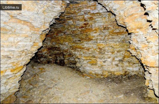
The Cave of the Institute of Geography of Siberia is the most famous cave in the Baikal area, discovered relatively recently by Irkutsk speleologists. It is 870 metres long and lies in the western foothills of the Primorsky Ridge within the Angi River basin, formed in dislocated marbleized limestone along tectonic and lithogenetic fractures. The entrance opens at the bottom of a karst sinkhole.
Inside, the cave is a system of passages and grottoes set on two hypsometric levels, with a height difference of 8 to 14 metres between them. The largest chamber, the Central Grotto, measures 90 metres long and 20 metres wide. Its calcite formations include stalactites, stalagmites and draperies, and the stalagmite in the Metropolitan passage stands about 3 metres high and 4.9 metres in diameter. Firn ice and ice stalagmites occur in the near part of the cave, where the air temperature holds around 4°C and humidity ranges from 76 to 88 percent.
Cave Aya: Features and Geology
Cave Aya is a karst cave on the western shore of Lake Baikal near Aya Bay, on the route between the mainland and Olkhon Island. The bay and cave take their name from a small sheltered inlet on the Maloye More side of the lake, an area rich in limestone outcrops and ancient rock art. Cave Aya formed in limestone through the same dissolution processes that shaped the wider Baikal speleological area, and its position close to the shoreline makes it a popular stop on guided excursions through the Tageran Steppe.
The cave sits within a landscape of cliffs, grottoes and petroglyph panels that draw both speleologists and cultural-tourism visitors. Because Cave Aya lies within the protected zone associated with Pribaikalsky National Park, access is managed and visitors are generally expected to enter with a guide who can interpret both the geology and the nearby archaeology.
Cave Mechta and Its Ice Formations
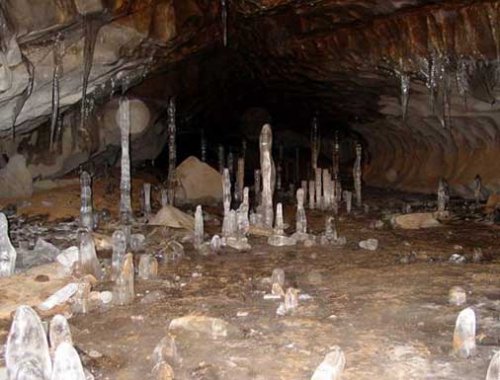
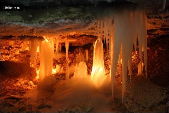
Cave Mechta is one of the longest karst caves in the Tageran Steppe area near Lake Baikal and is protected as a natural monument for its ice formations. The name "Mechta" means "Dream" in Russian, and the cave is prized for the ice stalactites, ice stalagmites and crystalline ice draperies that form in its cold interior chambers. These ice formations persist through much of the year thanks to the cave's stable low temperatures, a feature shared with several permafrost-influenced caves across the region.
As a designated natural monument, Cave Mechta carries legal protection that restricts damage to its fragile formations, and the nearby Cave Bolshaya Baidinskaya is another well-known karst cavity in the same steppe karst field. Visitors are asked to avoid touching the ice and calcite, which take centuries to grow and are easily broken.
Lurgikanskaya and Soktuyskaya Caves
The Lurgikanskaya and Soktuyskaya caves stand out among the karst caves of the Olekmo-Shilka province in the Baikal area. The Lurgikanskaya Cave lies on the left bank of the Lurgikan River, a tributary of the Shilka, formed in limestone composing a low rise. It consists of two large grottoes — one 120 metres long, the other 60 metres — each about 25 metres wide and 15 metres high, with a floor of stone blocks. Ice formations appear at its entrance in winter.
The Soktui Cave lies in the northern spurs of the Argun Mountains, 16 kilometres south of the village of Soktui Milozan, and was formed in marbleized limestone. It comprises five grottoes connected by narrow passages, with grotto lengths reaching 22 metres and heights of 16 metres, and large blocks of rock covering much of the floor. Soktui Cave is notably dry, and its total length is 130 metres.
Dzhugdzhur Speleological Area
The Dzhugdzhur speleological area contains six described karst caves, fewer than the Baikal area but notable for their underground ice and lakes. The caves here formed in Cambrian limestone along the Dzhugdzhur Ridge, and the cold northern setting means ice stalactites and stalagmites are a defining feature rather than a seasonal exception.
Abogydje Cave and Its Underground Lakes
Abogydje is the largest cave in the Dzhugdzhur speleological area, located on the left bank of the Mai River in Cambrian limestone. It is made up of five grottoes set at different heights and joined by low passages. Both its floor and ceiling are decorated with ice stalactites and stalagmites, and the cave holds three lakes, one of which remains ice-free year round — an unusual feature in a cavity otherwise dominated by permafrost ice.
Far Eastern Speleological Country
The Far Eastern speleological country lies in the extreme southeast of the region and extends the network of caves associated with the Baikal-Stanova system. It contains two regions, the Priamurskaya and the Primorskaya, each subdivided into limestone provinces that host substantial numbers of caves and natural mines.
Priamurskaya Region Caves
The Priamurskaya speleological area develops its underground karst cavities most widely in the Khingan-Bureya province, where 32 caves have been described. Among them are the Ice Cave, 120 metres long, and the Diturskaya Mine, a vertical cavity 75 metres deep. The province's limestone and the cold climate combine to produce both extensive horizontal passages and deep shafts.
Primorskaya Region Caves
The Primorskaya region divides into two speleological provinces, North-Sikhote-Alin and South-Sikhote-Alin, with the boundary running along the Bikan and Nakhtahe rivers. About 10 small karst caves have been described in the North-Sikhote-Alin province in Northern Primorye, located south of the town of Vyazemsky and in the basin of the Dolmi River, a right tributary of the Matai.
Karst caves are far more widespread in the South-Sikhote-Alin province, where about 70 caves and natural mines have been explored. The largest are Primorskaya, also called Primorsky Velikan, at 800 metres long, followed by Spasskaya at 760 metres, Mokrushinskaya at 150 metres and Priiskovaya at 120 metres. The Belaya mine near Olga Bay is of particular interest, descending 100 metres deep. Taken together, the Baikal caves and their Far Eastern counterparts are both widespread and remarkably diverse.
Cave Formations: Stalactites, Stalagmites and Limestone Structures
The Baikal Caves contain the full range of limestone speleothems — stalactites hanging from ceilings, stalagmites rising from floors, draperies, and massive columns where the two meet. These form as water carrying dissolved calcium carbonate seeps through the limestone and deposits calcite drop by drop, a process taking thousands of years. The stalagmite in the Metropolitan passage of the Cave of the Institute of Geography of Siberia, nearly 3 metres tall and almost 5 metres across at its base, is one of the most impressive single formations in the region.
Cave formations differ between caves according to water flow, temperature and rock type. Drier caves such as Soktui develop fewer dripstone features, while caves with steady seepage produce the richest draperies and columns. Because each formation records centuries of slow mineral deposition, speleologists treat them as both natural sculptures and archives of past groundwater conditions.
Ice Formations and Permafrost Caves
Many Baikal Caves contain permanent or seasonal ice, including ice stalactites, ice stalagmites and firn ice near their entrances. The cold continental climate of Eastern Siberia, combined with the stable low temperatures inside the caves, allows ice formations to survive long after the surface snow has melted. Cave Mechta is protected specifically for its ice, and Abogydje Cave in the Dzhugdzhur area carries ice formations on both floor and ceiling.
Beyond the caves themselves, Lake Baikal is famous for its winter ice. From roughly January to April the lake freezes into a sheet up to a metre or more thick, clear enough to see deep into the water below and shot through with turquoise pressure cracks. This crystalline "blue ice" and the ice grottoes that form against the shore — including the celebrated Blue Ice Cave formations near Olkhon Island — are among the most photographed frozen-lake phenomena on Earth, and they form a natural counterpart to the permafrost ice found underground.
Biodiversity and Endemic Species in Baikal Caves
The Baikal Caves shelter a sparse but specialised fauna adapted to darkness and cold, while the surrounding Lake Baikal ecosystem is one of the most biodiverse on the planet. Lake Baikal hosts more than 2,500 known animal species, the majority of them endemic, found nowhere else. The endemic fauna includes the Baikal seal, or nerpa, the world's only exclusively freshwater seal, which breeds on the lake ice in late winter and raises its pups in snow lairs.
The lake's fish life is equally distinctive. Endemic families such as the Comephoridae, the translucent oilfish or golomyanka, and the deep-water Abyssocottidae sculpins live at depths and pressures few other fish tolerate, and the recently described Neocottus thermalis is associated with the lake's hydrothermal vents. Lake Baikal also supports remarkable chemosynthetic ecosystems around methane seeps and hydrothermal vents on its floor, where chemautotrophic bacteria — rather than sunlight — form the base of the food web. The water owes its extraordinary clarity and high oxygen content partly to vast populations of endemic phytoplankton and zooplankton, and to aquatic plants including the introduced Elodea canadensis along the shallows.
Bat Species and Cave Fauna
Bats are the most conspicuous larger animals inside the Baikal Caves, with solitary specimens such as the mustached noctuid and the northern pipistrelle recorded in the Cave of the Institute of Geography of Siberia. These insectivorous bats use the caves for roosting and hibernation, relying on the stable temperature and humidity deep inside. Because populations are small and easily disturbed, cavers are asked to keep noise and lighting to a minimum, especially during the winter hibernation period when waking a bat can be fatal to it.
Archaeological Findings and Neolithic Sites in Caves
The caves and shoreline cliffs around Lake Baikal preserve a long record of human occupation stretching from the Neolithic Age through the Bronze and Iron Ages. Archaeological work in the region has uncovered tools, dwelling traces and ritual objects, including Neolithic fish-lures carved to imitate prey — a sign of how central fishing was to the lake's earliest inhabitants. Iron Age cave dwellings and tools point to later groups using the same sheltered cavities for habitation and refuge.
Ancient Petroglyphs Near Baikal Caves
The cliffs near several Baikal caves are decorated with ancient petroglyphs, the most significant cluster being the rock drawings at Sagan-Zaba Bay on the western shore. Sagan-Zaba preserves engravings spanning thousands of years, with Bronze Age images of shamans, dancing figures, deer and swans among the best known in Siberia. The early Soviet researcher P. Khoroshikh was among those who documented Baikal's rock art, and later studies linked many panels to the Kurykan people, ancestors of the modern Buryats and Yakuts who herded and fished along these shores. These petroglyph sites lie close enough to the caves that guided cultural tours often combine the two.
Buryat Culture, Legends and Cave Folklore
The caves, capes and rocks of the Lake Baikal shore are woven deeply into Buryat culture and shamanic belief. The Buryats, the largest indigenous people of the region with their homeland in the Republic of Buryatia and Irkutsk Oblast, traditionally regard many of these places as sacred dwellings of spirits. Shamanism remains a living practice here, alongside Buddhism in its Lamaist form, which spread among the Khorinsk Buryats and others from the south.
The most revered site is Shamanka Rock, also called Cape Burkhan, on Olkhon Island, where the Shaman Cave pierces the marble cliff. In legend the cave is the abode of the spirit Burkhan, or Gegen-Burkhan, a master of the island, and the site is associated in folk tradition with figures as distant as Genghis Khan. The nearby Valley of Stone Spirits and the imagery of women-shamans in the region's rock art reflect a worldview in which sacrificial rituals, prayer ties and offerings still mark the landscape. Older spirit-names such as Khan-gute-babay survive in Buryat oral tradition, attached to specific capes and caves along the coast.
Visiting Baikal Caves: Tours and Itineraries
Visiting the Baikal Caves is almost always done as part of a wider Lake Baikal tour based out of Irkutsk, the regional gateway city on the Trans-Siberian Railway. Most itineraries combine cave and cliff exploration with Olkhon Island, shamanic and Buryat cultural stops, and — in winter — driving on the frozen lake to reach ice caves and grottoes. Guided trips are the practical option because many sites lie within Pribaikalsky National Park, require local transport across ice or steppe, and benefit greatly from a guide's interpretation of the geology and folklore.
Baikal Caves Tour Overview and Pricing
A typical Baikal Caves and Olkhon Island tour runs as a multi-day guided programme combining caves, petroglyph sites and lake exploration. Pricing depends on group size, season and inclusions, so the most reliable figures come directly from operators rather than fixed published rates. A representative winter itinerary looks like this:
- Day 1: Arrival in Irkutsk, city sightseeing and transfer toward the lake.
- Day 2: Travel to Olkhon Island across the Maloye Morye Strait, visiting Cave Aya and shoreline grottoes en route.
- Day 3: Olkhon Island exploration — Khuzhir village, Shamanka Rock and the Shaman Cave at Cape Burkhan.
- Day 4: Northern island trip to Cape Khoboy, with winter ice driving and ice cave photography.
- Day 5: Hovercraft or hoverboat excursion on the ice and a visit to Ogoy Island and its Stupa of Enlightenment.
- Day 6: Return transfer to Irkutsk and departure.
Inclusions usually cover guide services, transfers, accommodation, most meals, national park fees and equipment for ice activities; international flights and travel insurance are typically excluded. Group sizes are commonly kept small for safety on the ice, and the prime season for ice caves and blue ice runs from roughly February to early April.
Accommodation and Eco-Lodges Near the Caves
Accommodation near the Baikal Caves ranges from hotels in Irkutsk to guesthouses and eco-lodges on Olkhon Island, mainly clustered around the village of Khuzhir. Olkhon lodges tend to be simple wooden guesthouses with shared dining, banya (Russian sauna) facilities and wood heating, chosen for their proximity to Shamanka Rock and the northern capes rather than for luxury. On the mainland, Irkutsk offers full-service hotels with the amenities international travellers expect, making it the usual base for arrival and departure nights.
Alternative Lake Baikal Tours and Activities
Beyond cave exploration, Lake Baikal offers a wide range of alternative tours and activities across all seasons. Popular options include the historic Circum-Baikal Railway excursion along the southern shore, hiking in Pribaikalsky National Park, boat trips to spot the Baikal seal, and visits tied to the lake's scientific heritage. Lake Baikal is also a centre for research: it hosts a deep underwater neutrino telescope used in particle-physics experiments, was explored by the Mir submersibles that reached its deepest point, and has been studied for decades by Russian scientists. The multi-generational Kozhov family research programme — led by Mikhail Kozhov and continued by Olga Kozhova and others — built one of the world's longest continuous freshwater monitoring records on the lake. Sediment cores drilled from the lake floor preserve detailed paleoclimate archives reaching back millions of years.
Culinary Experiences and Local Meals
Meals on a Baikal tour centre on local Siberian and Buryat cooking, with the lake's fish at the heart of the table. The signature dish is smoked or salted omul, a whitefish endemic to Lake Baikal, often eaten with bread and served lakeside. Buryat cuisine adds buuzy (steamed meat dumplings), hearty soups and dairy dishes suited to the cold climate. Most guided itineraries include breakfast and dinner at the lodges plus packed lunches for full-day excursions, with tea breaks a constant feature of the Siberian table.
Customer Testimonials and Reviews
Travellers consistently describe the Baikal Caves and winter ice tours as a highlight of visiting Siberia, praising the combination of geology, frozen-lake scenery and Buryat culture. Reviewers frequently single out the sense of remoteness, the quality of local guides and the surreal experience of driving across metre-thick clear ice to reach ice caves. Independent traveller discussion on platforms such as Reddit echoes this, with visitors recommending small-group winter trips and noting that knowledgeable local guides make the difference between a sightseeing stop and a genuine understanding of the sacred sites at Shamanka Rock and Cape Burkhan.
Practical Tips for Exploring Baikal Caves
Exploring the Baikal Caves safely takes preparation for cold, remoteness and Russian travel logistics. A few practical points cover most of what independent and guided visitors need:
- Season: Visit between February and early April for blue ice, ice caves and reliable ice driving; summer suits cliff caves, hiking and boat trips.
- Equipment: Bring insulated boots, layered clothing, ice grips, a headlamp and gloves; ice activities require operator-supplied safety gear and a guide who knows current ice conditions.
- Transport: Reach the region via Irkutsk on the Trans-Siberian Railway or by air, then continue by road and across the ice by vehicle, hovercraft or hoverboat; ATV and off-road transfers are used on the steppe and northern capes.
- Respect sacred sites: At Shamanka Rock, the Shaman Cave and the Valley of Stone Spirits, follow local customs, keep to marked areas and avoid disturbing offerings.
- Protect formations: Do not touch or break stalactites, stalagmites or cave ice, which take centuries to grow and are legally protected in monuments like Cave Mechta.
- Connectivity and access: Mobile coverage is patchy on Olkhon Island; download maps offline in advance, and be aware that some travellers choose to set up a VPN before arriving in Russia to maintain access to familiar services. If a booking or operator website returns a network-security block or login error, contact the operator directly or file a support ticket rather than retrying repeatedly.
With a reliable guide, the right gear and a respect for both the fragile cave environment and the living Buryat traditions that surround it, the Baikal Caves offer one of Siberia's most rewarding combinations of natural and cultural exploration.