Karst Caves of the Altai-Sayan Region: A Speleological Guide
 libre
libre
The Altai-Sayan country is divided into four speleological areas — Altai, Salairo-Kuznetsk, Sayan and Tuva — that together hold one of the richest concentrations of karst caves in northern Asia.

Altai-Sayan: Geography and Location
The Altai-Sayan mountain range sits at the heart of Eurasia, where the Siberian taiga forests of the north meet the steppes and Central Asian deserts of the south. The region forms a vast mountainous knot in southern Siberia and Central Asia, spanning roughly one million square kilometres and rising to peaks above 4,500 metres. Its position at the crossroads of several biological and cultural zones gives the Altai-Sayan its unusual diversity of landscapes, from glaciated summits to dry intermontane basins.
Altai-Sayan Mountain Range Overview
The Altai-Sayan mountains are a system of interlocking ranges, plateaus and basins rather than a single linear chain. Glaciers cap the highest massifs, feeding alpine meadows, dense conifer forest, and arid grassland in turn as elevation drops. The Ukok Plateau, a high windswept tableland in the Altai Republic, is among the most striking features — a UNESCO-listed landscape of permafrost steppe and frozen burial mounds. Vegetation ranges from Siberian larch and cedar taiga on shaded northern slopes to feather-grass steppe on sun-exposed southern faces, producing exceptional habitat variety within short distances.
Major rivers rise in these mountains and supply much of the surrounding region. The Ob River and the Yenisei River, two of the largest watersheds in Siberia, both draw headwaters from Altai-Sayan glaciers and snowfields. Numerous lakes and freshwater reserves lie in the basins between ranges, and the wider hydrological system connects toward Lake Baikal to the east, reinforcing the region's role as a continental water tower.
Cross-Border Geography Across Russia, Mongolia, China and Kazakhstan
The Altai-Sayan mountain range crosses four countries: Russia, Mongolia, China and Kazakhstan. The bulk of the speleological terrain and the Altai Republic (also called the Republic of Altai) lie within Russia, but the mountains continue south and east into Mongolian, Chinese and Kazakh territory. This cross-border geography makes the Altai-Sayan a natural candidate for multi-country strategic planning and international conservation cooperation, since wildlife, watersheds and migration routes do not follow political lines.
Speleological Subdivision of the Altai-Sayan Country
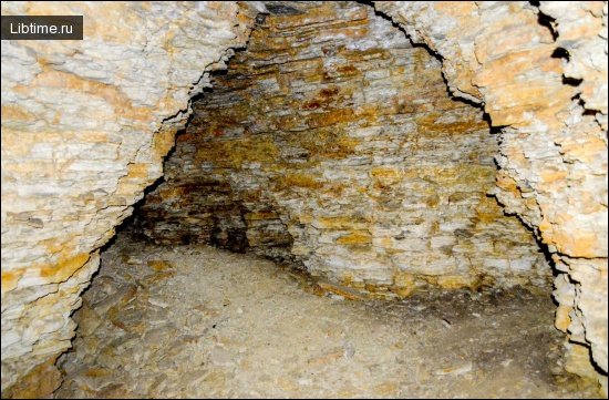
The Altai-Sayan country is subdivided into four speleological areas: Altai, Salairo-Kuznetsk, Sayan and Tuva. Within the Altai region, the distribution and morphology of underground cavities split the territory into three speleological provinces: West-Altaic, Central-Altaic and East-Altaic. Caves cluster where soluble Cambrian, Silurian and Ordovician limestones are exposed and heavily fractured, which is why mapped systems concentrate along certain river valleys and watershed ridges.
Altai Speleological Region
The Altai speleological region holds more than 300 identified karst caves and mines, with 203 of them mapped. The three provinces differ markedly in cave size and abundance, from the many small cavities of the west to the larger, more developed systems of the centre and east.
West-Altaic Province
The West-Altaic province, covering the ore Altai and the latitudinal watershed ridges of the Southern Altai, has a wide spread of karst caves that are mostly small. The largest include Pryamukhinskaya at 400 m long, Tulatskaya at 300 m, Yashchurskaya at 210 m and Gromotushenskaya at 140 m. Despite the abundance of openings, few extend deeply, reflecting the thin and fragmented limestone outcrops of the western ranges.
Central-Altaic Province
The Central-Altaic province contains the longest caves in the Altai region, led by Museinaya at 700 m, Bolshaya Chuyskaya at 547 m and Karakolskaya at 306 m. Among the karst mines here, Ingurskaya reaches 63 m deep and Opasnaya 53 m deep.
Museinaya Cave
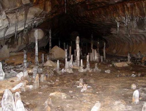
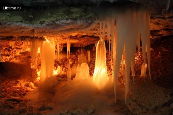
Museinaya Cave lies on the right bank of the Karakol River, a left tributary of the Anuya River, about 3 km below the village of Karakol. It is developed in Lower Silurian limestones and consists of several grottoes connected by narrow passages and low manholes that follow tectonic fractures of northeastern and northwestern extent. Nate formations are widely developed; the most striking are corallites — bushy, tree-like stalagmites that resemble coral colonies. The total length of Museinaya Cave is 700 metres. 
Karakolskaya Cave
Karakolskaya Cave is located just 0.1 km north of Museinaya Cave and contains several grottoes, the largest reaching 2 m in length, 10 m in width and 7 m in height. The cave has several floors connected by wells. In the lower grottoes, nate formations are abundant — stalactites, stalagmites, columns and draperies. The total length of Karakolskaya Cave is 306 metres.
East-Altaic Province
The East-Altaic province is dominated by larger systems, the biggest being Geophysical at 500 m, Karakokshinskaya at 260 m and Bolshaya Belobomskaya at 146 m. These caves tend to be deeper and more vertically complex than those of the western province.
Geophysical Cave
Geophysical Cave sits on the watershed of the Ustyuba River and its left tributary Svetly Creek, 3 km north of the village of Verkhny Ustyuba. Its entrance lies at the bottom of a karst sinkhole 80 m in diameter and 25 m deep, formed in heavily fractured Lower Cambrian limestones. The cave has several floors joined by wells up to 12 m deep and contains two large grottoes. The largest, the Upper Grotto, sits 65 m below the floor of the sinkhole and reaches 50 m in length and 20 m in height, with well-developed columns, draperies and stalactites. The total length of Geophysical Cave is about 500 m and its depth 130 m.
Salairo-Kuznetsk Speleological Region
In the Salairo-Kuznetsk region, karst caves are most widespread in the Kuznetsk-Alatau speleological province, where seven caves have been studied. This region is more sparsely caved than the Altai or Sayan, but it contains one of the most notable single systems in the whole country.
Kashkulakskaya Cave
Kashkulakskaya Cave is the largest cave in the Salairo-Kuznetsk region, developed in Cambrian limestones and reaching 600 m in length and 65 m in depth. Beyond its dimensions, Kashkulakskaya is widely known for its long association with ancient ritual use; its entrance grotto has yielded traces of human activity and is often linked in regional accounts to shamanic practice, making it a frequent subject of both speleological and archaeological interest.
Sayan Speleological Region
The Sayan region is divided into three speleological provinces: West Sayan, Minusinsk and East Sayan. East Sayan is by far the best explored and holds the longest cave in the entire Altai-Sayan country.
East Sayan Province
The East Sayan province is the most thoroughly explored, with more than 150 karst caves identified and described. The principal systems include Bolshaya Oreshnaya at 11,000 m long and 160 m deep, Badejskaya at 5,500 m and 170 m, Kubinskaya at 2,500 m and 274 m, Torgashinskaya at 1,500 m and 174 m, Belaya at 900 m and 100 m, Temnaya at 650 m and 42 m, Divnogorskaya at 515 m and 60 m, Pervomayskaya at 500 m and 55 m, and Karaulnaya II at 360 m and 38 m.
Bolshaya Oreshnaya Cave
Bolshaya Oreshnaya is the longest cave in the Altai-Sayan country at roughly 11,000 m of surveyed passage and a depth of 160 m. Developed in conglomerates rather than typical limestone, it forms a dense three-dimensional maze of interconnected galleries, which makes it a favourite among experienced cavers and a benchmark site for Siberian speleology.
Kubinskaya Cave
Kubinskaya Cave lies on the left bank of the Biryusa River, 2 km from its mouth, developed along tectonic fractures in Lower Cambrian limestones. Its entrance sits 280 metres above the Yenisei.

West Sayan and Minusinsk Provinces
The West Sayan and Minusinsk provinces are less explored than East Sayan but contain several substantial systems. In the Minusinsk province, karst caves are concentrated in the Solgonsky and Batenevsky ridges, where more than 50 underground cavities have been described. The largest are Borodinskaya at 1,020 m, Tamozhenskaya at 350 m, Oktyabrskaya at over 200 m long and 71 m deep, Demidovskaya at 160 m and Bidzhinskaya at 150 m.
Two notable caves in the East Sayan–Minusinsk borderlands sit in unusual rock. Torgashinskaya Cave, in Davydovy log 5 km from the settlement of Torgashino near Krasnoyarsk, is developed in Lower Cambrian limestones with a complex structure; its entrance is a 40 m well and its largest grotto, Myshiny, reaches 85 m long and 25 m wide, giving a total length of 1,500 m and depth of 174 m. The Belaya and Temnaya caves, excavated in Ordovician conglomerates near the village of Stepnoi Bajei, are heavily branching systems, with Belaya (the White Cave) reaching 900 m in length and 100 m in depth.
Tuva Speleological Region
The Tuva speleological region forms the fourth and southernmost division of the Altai-Sayan country, set among the dry ranges and basins that grade toward the Mongolian frontier. It is the least developed of the four areas in terms of mapped systems, reflecting both its remoteness and its more arid karst, where limited surface water restricts the dissolution that drives cave formation. The region nonetheless completes the speleological picture of the Altai-Sayan, linking the well-studied Sayan systems to the highland karst of the Russia–Mongolia border zone.
Altai-Sayan Ecoregion and Biodiversity
The Altai-Sayan Ecoregion is one of the most biologically rich temperate landscapes on Earth, recognised by WWF as a Global 200 priority region. Lying where Siberian taiga forests, mountain steppe and the Central Asian deserts converge, the ecoregion packs an extraordinary range of habitats into a relatively compact area, from glacier and alpine tundra to forest, grassland and semi-desert.
Endemic Species and Biodiversity Statistics
The Altai-Sayan Ecoregion supports flagship and endemic species found in few other places, making it a global conservation priority. Its mountains shelter the Snow Leopard, the Altai Argali (the world's largest wild sheep), and the Mongolian Saiga, alongside many endangered and near-threatened species. Forest composition spans Siberian larch, pine, spruce and cedar across shaded slopes, with steppe and meadow communities adding to the vegetation diversity. The combination of high endemism and intact wilderness is what underpins the region's standing as a centre of biodiversity in inner Eurasia.
Central Asian Landscape Conservation
Central Asian landscape conservation in the Altai-Sayan is coordinated largely through WWF and its national partners, including WWF-Russia. WWF operates through a global network of offices structured around country and regional programmes, and the Altai-Sayan sits within its priority places for inner Asia. Conservation work focuses on protecting connected habitat across the Russia, Mongolia, China and Kazakhstan border zone rather than isolated reserves, recognising that species like the snow leopard range across all four countries.
Conservation Case Studies
Conservation case studies in the Altai-Sayan combine protected-area management with anti-poaching and legislative work. WWF conservation strategies in the region have supported the development of new protected areas and supporting legislation, strengthened ranger patrols against wildlife poaching and illegal trade, and promoted international cooperation on shared species. The Ukok Plateau is a frequent focus, where conservation efforts aim to safeguard a fragile permafrost-steppe landscape of high ecological and cultural value while managing competing land-use pressures.
Climate Change Impacts on the Region
Climate change is reshaping the Altai-Sayan by shrinking glaciers, altering river flow and shifting habitat belts upslope. Because the Ob and Yenisei watersheds depend on Altai-Sayan snow and ice, glacier retreat threatens water security far downstream as well as the alpine habitats of high-elevation species. Warming also pushes the boundaries between forest, steppe and tundra, squeezing cold-adapted wildlife into ever-smaller ranges.
Deforestation, Mining and Human Threats
The main human threats to the Altai-Sayan Ecoregion are deforestation, mining, overgrazing and poaching. Logging and mineral extraction fragment forest and disturb watersheds, while unmanaged livestock grazing degrades fragile steppe and meadow ecosystems through erosion and loss of plant cover. Wildlife poaching and illegal trade target high-value species such as the snow leopard and argali, compounding the pressure from habitat loss and making economic and ecological threats tightly linked.
Community Livelihood Enhancement Programs
Community livelihood enhancement programs aim to reduce pressure on Altai-Sayan ecosystems by giving local people sustainable income alternatives. Such initiatives support herding practices that limit overgrazing, develop nature-based tourism and handicrafts, and involve residents directly in protected-area management and anti-poaching work. By tying conservation to local prosperity, these programs make long-term environmental sustainability more achievable across the cross-border landscape.
Rock Art and Archaeology of the Altai-Sayan
The Altai-Sayan is one of the great rock art landscapes of Eurasia, with carvings spanning from the Upper Paleolithic through the Eneolithic period and later. Ancient artists used vertical walls, rocky cliff formations and isolated boulders as canvases, leaving engraved and pecked images across river valleys and mountain passes. The imagery records the region's wildlife, beliefs and changing ways of life over many thousands of years.
Deer and Elk Depictions in Siberian Rock Art
Deer and elk are among the most frequent subjects in Altai-Sayan and wider Siberian rock art, often rendered with great care and at large scale. These zoomorphic figures sit alongside depictions of horses, goats and other Siberian steppe fauna, reflecting both the animals people hunted and those that held symbolic meaning. The prominence of antlered animals in particular points to their ritual significance across long stretches of prehistory.
Anthropomorphic Motifs and Human Figures
Anthropomorphic motifs — human and part-human figures — form a distinctive layer of Altai-Sayan rock art, frequently shown with ritual paraphernalia and ornaments. Some figures carry drums or wear elaborate headdresses, and researchers commonly interpret these drum-carrying figures as shamans, linking the carvings to the shamanic traditions long documented in Siberia. Geometric figures and patterns often accompany the human and animal images, adding a symbolic dimension that is harder to decode.
Boulder Carvings and Isolated Rock Art Sites
Many Altai-Sayan rock art sites take the form of carvings on isolated boulders rather than continuous cliff panels. These boulder carvings, scattered across plateaus and valley floors, can be dated in part to the Eneolithic period and represent some of the more accessible and intimate examples of the region's prehistoric art. Their isolated settings make them vulnerable to weathering and disturbance, and they are an important focus of documentation efforts.
Archaeoacoustic Research in Cave and Rock Art Studies
Archaeoacoustics is an emerging research method applied to Altai-Sayan rock art and cave sites, studying how sound behaves at decorated locations. Archaeoacoustic research investigates whether rock art panels and cave chambers were chosen partly for their acoustic properties — echoes, resonance and reverberation — which may have heightened ritual experience. This approach adds a sensory dimension to interpretations that traditionally rely on imagery alone, and it complements ongoing research and documentation of the region's archaeological heritage.
Visiting the Altai-Sayan Caves: Practical Information
Visiting Altai-Sayan caves requires preparation, since most systems are wild, undeveloped and reached only after travel into remote mountain terrain. Many of the caves described here — from Geophysical and Kubinskaya to Bolshaya Oreshnaya — involve vertical wells, water and complex passages that demand caving experience, proper equipment and ideally a knowledgeable guide. Visitors should respect protected-area rules, avoid damaging the delicate nate formations and rock art, and plan around the short Siberian field season. For more cave systems and trip notes, see our wider Speleology coverage and the related Travel and Stories sections.