How Snow and Ice Shape Mountains: Snow Line, Avalanches, and Glacial Action
 libre
libre
The work of snow and ice is most visible in the mountains. On high peaks so much snow accumulates that it never melts, even in summer, above the snow line — which is why it is called perpetual snow. This article explains how snow and ice operate in mountain environments, how glaciers form and move, and the landforms they leave behind, and then turns to a practical companion subject many readers search for alongside it: how communities and property owners manage snow and ice on the ground.
How do snow and ice work in the mountains?
Snow and ice work in the mountains by accumulating above the snow line and then being discharged through wind, avalanches, and the slow flow of glaciers. High mountains never fully shed their snow, yet they show no appreciable annual growth from the snow that keeps falling. That balance — constant supply met by constant removal — is the central fact of mountain glaciology, and each removal mechanism leaves its own signature on the landscape.
What determines the height of the snow line?
The height of the snow line is not the same everywhere; it varies considerably even within the same geographic latitudes. The snow line is the elevation above which snow persists year-round, and it responds to several local factors rather than to latitude alone.
Several causes influence the height of the snow line:
- the average summer temperature,
- the orientation of slopes relative to the sun (a south-facing slope raises the line, while a north-facing slope lowers it),
- the prevailing wind direction,
- the amount of snowfall.

High mountains are never freed of snow, but at the same time they do not visibly grow taller from the snow added each year. This regional variation in how snow behaves at altitude mirrors, on a far larger scale, the regional differences in cold-weather preparedness seen between places like New York and Texas, where snow line concepts give way to questions of road salting and storm readiness.
What factors affect the height of the snow line?
Summer warmth and slope aspect are the strongest controls on the snow line, but wind and snowfall volume reshape it locally. A ridge swept clear by wind can sit bare beside a sheltered hollow buried in firn. Because these factors combine differently on every massif, two summits at the same latitude can carry their snow lines hundreds of meters apart.
How do mountains shed their snow?
Mountains shed their snow chiefly in two ways, since constant accumulation must be balanced by removal:
- wind blows it off summits, ridges, and steep slopes,
- snow slides, or avalanches, carry it away — often causing enormous destruction.
The action of an avalanche can be compared to a snowball rolled off a roof covered in fresh snow: it grows larger and larger as it goes. In the same way, the slightest trigger in the mountains — an animal's leap, a gunshot, and so on — can be enough for the jolt or the concussion of the air to set the loose mass of newly fallen snow moving on steep slopes, giving rise to so-called dry avalanches.
How does wind unload snow from peaks?
Wind unloads snow by scouring it from exposed summits, crests, and steep faces and redepositing it on leeward slopes. This continuous redistribution is why windward ridges often appear nearly bare while sheltered basins fill with deep drifts that later feed glaciers. Wind transport is the quietest of the discharge mechanisms but acts every day the air moves.
What are snow avalanches?
Snow avalanches are masses of snow that detach and rush down a slope, and they come in three principal types distinguished by their water content. Avalanches are among the most destructive expressions of the work of snow, and understanding their type helps predict their reach and force.
What is a dry avalanche?
A dry avalanche forms when loose, newly fallen snow on a steep slope is set in motion by a minor trigger such as a sound or a passing animal. Dry avalanches travel fast on a cushion of air and are typical of cold conditions, when the snow has not yet been wetted or bonded to the ground beneath it.
What is a wet avalanche?
A wet avalanche forms when snow becomes saturated with water and its bond to the underlying ground weakens. Wet avalanches are far more destructive than dry ones: tearing away from the ground, they carry off masses of earth, rubble, and stone — even whole boulders, trees, and the carcasses of animals.
What is an ice avalanche?
An ice avalanche, more terrible still than a wet avalanche, occurs when blocks of glacier ice break loose and crash down a slope. Ice avalanches deliver the greatest concentrated mass of any type and are especially dangerous where glaciers terminate over cliffs above inhabited valleys.
How fast and destructive are avalanches?
An avalanche can reach a speed of 180 meters per second — that is, 648 km/h. It races faster than the Japanese high-speed Shinkansen train, whose record speed is 443 km/h on ordinary railway lines and 581 km/h on magnetic levitation, the latter being the absolute world record for trains.
Like a hurricane, an avalanche sweeps away everything in its path. Avalanches pose a significant threat to mountain roads, which is why engineers build protective structures along the most exposed routes.
How are mountain roads protected from avalanches?
Mountain roads are protected from avalanches by sturdy galleries — covered sheds with sloping roofs that let a slide pass over the road and down into the ravine without burying it. On the Georgian Military Road, such galleries were built at the most threatened points specifically to channel avalanches into the gorge below. These engineered shields are an early ancestor of modern winter-road defense, where the emphasis shifts from deflecting snow to melting and treating it.
What are glaciers?
Glaciers are the slower, calmer means by which mountains unload their snow. Glaciers form in basins between mountains — otherwise known as cirques — where a great deal of snow accumulates. Under the influence of sunlight, warm air, rain, and meltwater, this snow takes on a granular structure and is called firn.
How do glaciers form?
Glaciers form through the gradual transformation of accumulated snow into dense ice within a cirque. Snow first becomes firn, then firn ice, and finally glacier ice as pressure squeezes out the air and the crystals grow. Once the mass is thick enough, gravity sets it flowing downslope, and a glacier is born.
What is firn?
Firn can be pictured as the melting snow of springtime. Firn is never uniform: distinct layering is visible in it, because wind constantly carries fine dust from the rocks onto the freshly fallen snow. When the snow is soaked with water and then refreezes, the whole mass acquires a granular-crystalline structure, and firn turns into firn ice.
What is firn ice?
Firn ice is whitish in its upper layers because of the air bubbles trapped within it. Gradually compacting under pressure, firn ice becomes transparent and blue — glacier ice. It, too, has a layered structure, which can be clearly seen on the walls of glacial crevasses.
What is glacier ice?
Glacier ice is the dense, transparent-blue ice that results when firn ice is compressed under the weight of overlying layers. Firn fields, or accumulation zones, have outflow areas from which glacial streams — glaciers — emerge. Glacier ice retains a layered fabric and possesses an interesting property: plasticity.
What is the plasticity of ice?
The plasticity of ice is the property that allows a glacier to creep slowly down the lowered edge of its basin. Plasticity is the ability of a material — such as clay, wax, or cobbler's pitch — to take on any shape; this very quality is what makes certain plastic materials useful for modeling.
You cannot, of course, mold anything out of ice, yet if you chip it into pieces, pour them into a jar, and set it in the cold, after a while they will fuse into a single solid block. This plasticity is what causes a glacier to slide slowly along. The movement of glacial streams can be likened to an icy river.
How do glacial streams move?
Glacial streams move by flowing slowly downhill under their own weight, deforming plastically as a river of ice. The middle of the glacier advances faster than its edges, exactly as the midstream of a river runs faster than the banks. This differential flow opens crevasses and bends any line of markers laid across the surface.
How fast do glaciers move?
The speed of glacier movement depends on many causes. One must account for the size of the glacier, the air temperature (in the warm season a glacier moves faster, in the cold season slower), and the steepness of the slope (movement is naturally faster on a steep slope than on a gentle one). Glacier speeds vary from 0.1 meter per day up to 38 meters per day in the Greenland glaciers (more details: Explorers of the North Pole).
The movement of ice can easily be detected by laying a row of stones across a glacier at intervals. The curving of this line will reveal the glacier's movement after some time, and in the central part of the glacier the stones shift considerably faster than along the edges.
The comparison of a glacier to a river is rounded out by so-called icefalls, which form on sheer descents. The faster motion in the central part and the friction against the edges of the glacier's bed encourage the formation of short, shallow marginal crevasses oriented opposite to the ice's advance. Transverse crevasses are also distinguished, while at the glacier's terminus longitudinal crevasses form.
Stones tumbling from the slopes drop into the crevasses. Falling all the way to the glacier's bed, they travel along with the ice, leaving deep scratches on the rocks over which the glacier moves. Snow often covers these treacherous crevasses (usually 1–2 meters wide) in an even layer, making them the chief danger for tourists and glacier researchers. The depth of the crevasses varies, and the thickness of the ice cover is generally still poorly studied. In the Alpine and Caucasian glaciers it reaches 200 and even 400 meters, while the thickness of the Greenland continental ice is estimated at 2,000 meters.
What geological work do glaciers perform?
Glaciers perform powerful geological work: an enormous mass of ice, a glacier gouges deep furrows in soft rock, polishes hard rock while scoring it with the stones it drags along its bed, and carries great boulders on its surface. The valleys through which a glacier has passed are easy to recognize by their steeper, sheerer walls and their broad, concave floors carved by the ice.
What landforms does glacial erosion create?
Glacial erosion creates distinctive landforms, including roches moutonnées ("sheep's-back rocks") and "fluted rocks." A roche moutonnée has one gentle slope, up which the glacier climbed, and one steep slope, down which it descended after crossing the obstacle; the steep face is also scored with deep scratches.
Fluted rocks stand out for their rounded outlines and the flat hollows between the separate projections worked by the glacier. Glaciers also smoothed the rocky bed over which they moved, leaving deep striations on it. By these striations one can now, tens of thousands of years later, precisely determine the direction in which an ancient glacier traveled. The glacier ploughed the rock like a field, leaving great hollows and depressions later filled by lake water — thousands of such lakes are scattered across Karelia.
What are moraines and glacial deposits?
Moraines are accumulations of rock debris carried and deposited by a glacier, and glaciologists distinguish surface and internal glacial formations. Surface glacial formations include lateral moraines, medial moraines, glacier tables, and glacier cups; internal glacial formations include englacial moraines and ground (basal) moraines.

Lateral moraines are the ridges that form along both sides of a glacier from stones of various sizes that tumble onto it from the mountains. Medial moraines form when glaciers merge: besides their lateral moraines, the joined glaciers produce shared medial moraines. One can always tell how many glaciers merged, because there will always be one more moraine than the number of merged glaciers — four moraines, for example, indicate a glacier formed from the joining of three.
Glacier tables arise when blocks that fell onto the ice are carried farther and farther along with it. In the warm season the stone is strongly heated by the sun, the ice around it begins to thaw, and gradually the block is left resting on a massive pedestal of ice — sometimes 5–6 meters high. When the stem thaws enough for the block to topple onto the ice, the process repeats until the glacier carries its load down to the terminal moraine.
Glacier cups form when smaller, especially dark, flat stones absorb the sun's heat better, melt the ice beneath them, and sink to varying depths; a larger stone makes a wider, deeper pit than a small one. These little cylinders, 10–40 centimeters deep, with the stone lying at the bottom, are called glacier cups.
Englacial and ground moraines form inside and at the base of the glacier from the stones that fall through the crevasses. The rock material of a ground moraine is easily distinguished by appearance from the other stones lying both on top of and within the glacier: through friction against the hard bed and against one another, these stones become rounded and, in addition, are covered with scratches and scoring. The stones that fell onto the glacier, lay within it, and were dragged beneath it gathered as an enormous ridge at the glacier's lower end in the form of a terminal moraine — and here, as the ice melts, a turbid stream of glacial water bursts out from beneath it.
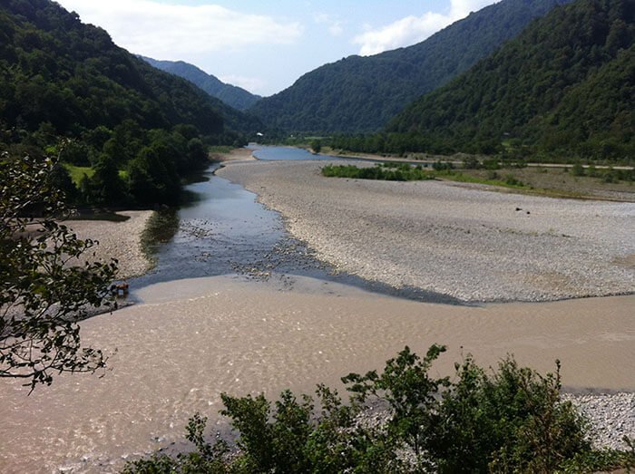
How does glacier melt produce rivers?
Glacier melt produces rivers where meltwater emerges from beneath the terminal moraine as a turbid stream and gathers into a flowing channel. This is why so many mountain rivers begin at a glacier's snout. The far more extensive work of snow and ice during the Ice Age — more precisely, the epoch of repeated glacial advances and retreats at the start of the Quaternary — reshaped whole continents (more details: The geological age of the Earth).
At that time about one-fifth of the Earth's surface was covered by continuous masses of ice in both the northern and southern hemispheres. Polishing marks on the rocks of the narrow Norwegian inlets — the fjords that cut deeply into the land in the southwestern part of the Scandinavian Peninsula — testify that the ice cover was no less than 2–3 kilometers thick.
A thick mass of ice lay as a continuous cover over the northern and central parts of Europe and occupied considerable territories of Asia and North America. In Western Europe the ice sheet extended roughly to the Alps, which were themselves covered with ice. Precise studies show that vast stretches of Eastern Europe were ice-covered, the ice at times descending in two enormous tongues — along the Dnieper almost to Dnipropetrovsk and along the Don south of 50° N, that is, roughly to the latitude of Volgograd.
Modern glaciation and climate change
Through long and painstaking work, scientists have established that Europe experienced four glaciations with three warm intervals between them. The first glaciation began roughly 500,000 years ago — relatively recently, when primitive humans had already appeared on Earth — and the last ended 25,000 years ago.
The study of so-called varved clays, formed on the beds of now-vanished glacial lakes, brought considerable clarity to ideas about the life of a glacier. As the great ice sheet melted, large and small glacial lakes arose on the territory it freed. On their beds, thin alternating layers of sand and silty clay particles brought by meltwater were deposited: in spring and summer a considerable amount of coarser sandy material entered the lakes, while in autumn and winter only the finest silt settled. Varved clays thus represent a regular alternation of lighter and darker layers of differing sediment composition.
Having deciphered the nature of varved clays, scientists calculated that the glacier left the environs of St. Petersburg 12,000 years ago. Swedish scientists, also by counting the layers of varved clays in a number of former lakes in southern Sweden, established that during a warming epoch the great glacier retreated 200–225 meters per year.
Despite a large number of hypotheses, the causes of the glaciations remain unexplained. The work of snow and ice in antiquity far exceeded that of today. The pressure of the ice sheet was so great that the glacier seemed to shave off everything that stood in its way: from once-lofty mountains only modest rises now remain.
The products of these mountains' destruction — boulders, pebbles, gravel, sand, and clay (Rocks that make up the Earth's crust) — cover millions of square kilometers in the northern parts of Europe, Asia, and North America. Boulders sometimes reach enormous sizes — up to 5,000 cubic meters. Such a "pebble" can be compared in height to a four-story house.
One of the giant boulders — the "Thunder Stone" — became, after shaping, the pedestal of the "Bronze Horseman" (the monument to Peter I in St. Petersburg).
For a long time science had no correct explanation for the origin of boulders. This riddle was brilliantly solved by the Russian scientist and revolutionary P. A. Kropotkin (1842–1921). Indeed, only a mighty glacier could have dragged giant boulders and other rock material represented precisely by the rocks characteristic of the Scandinavian Peninsula.
People make wide use of the valuable gifts of ancient glaciers in their economy — boulder stone, otherwise cobblestone, gravel, sand, and clay. Boulders scattered across the fields of vast territories and often found in riverbeds are excellent road-building material; the durable stone pavements of many cities, now hidden under asphalt, rest on a cobblestone base. Cobblestone broken into crushed stone is also widely used for highway surfaces, gravel makes strong concrete, and sand and clay have even broader uses.
The picture of the great glaciation is to some extent reconstructed by the powerful ice cover of Greenland. This vast, uninhabited island (and possibly archipelago) is covered in its interior by a continuous ice sheet reaching a thickness of two thousand meters. The Greenland glaciers reach the very ocean and unload enormous blocks of ice into it — "icebergs" (from the English for "ice mountains").
Icebergs sometimes rise 100 meters or more above the water, yet their outward dimensions are no guide to their true size, since only one-sixth of an ice block rises above the surface.
Driven by the cold Greenland current, icebergs sometimes reach southern latitudes and pose a great danger to shipping. In 1912 the largest ocean liner of its time, the Titanic, struck an iceberg in the fog and went to the bottom, taking many human lives with it (more details: Floating ice).
How do communities and properties manage snow and ice on the ground?
Communities and property owners manage snow and ice on the ground through a coordinated system of plowing, chemical treatment, and—where the budget allows—engineered snow-melt systems. Where mountain glaciology describes how snow is removed by nature, municipal snow and ice control describes how people remove it from roads, sidewalks, and driveways. The two share the same physics of freezing and melting, applied at very different scales.
What does a snow and ice control operation involve?
A snow and ice control operation involves road crews and snow plow operators clearing and treating roadways according to a documented plan, typically set out in a jurisdiction's Snow and Ice Control Operations Manual or Maintenance Management Manual. District planning for winter conditions draws on weather history and resource planning to size crews, salt stocks, and equipment before the season. Public notification and media alerts — coordinated through outlets such as WFMyNews2 — and coordination with law enforcement and the Department of Public Safety keep the public informed during a storm.
How are roads cleared in priority order during a storm?
Roads are cleared in a priority order that puts the busiest and most safety-critical routes first. A typical priority of work hierarchy is:
- emergency operations and routes classified as highest priority (hospitals, emergency services);
- major highways and arterial roads carrying the heaviest traffic;
- collector and secondary streets;
- residential streets and cul-de-sacs.
This clearing priority sequence explains the common experience of uneven snow removal across nearby streets: a main road may be bare while a side street is still snow-covered because the two sit at different levels of the hierarchy. Known trouble spots — hills, bridges, and railroad grade crossings — receive extra attention, and a Highway Condition Report documents which routes are open, treated, or closed for road closure procedures.
How do snow plows operate safely and efficiently?
Snow plows operate safely by traveling at controlled, moderate speeds and positioning the blade to cast snow toward the road shoulder rather than into intersections or driveways. Snow plow operators manage blade angle and down-pressure to scrape efficiently without damaging the pavement. Modern fleets use GPS tracking and route analysis to optimize plow routes, confirm coverage, and maintain equipment efficiency, while careful snow pile management at crossings and railroad grade crossings keeps sight lines clear. Mechanical clearing with plows and loaders handles the bulk of deep snow, with loaders hauling away piles where there is nowhere to push them.
How does salt remove snow and ice?
Salt removes snow and ice through freezing-point depression: dissolved salt lowers the temperature at which water freezes, so ice melts and refreezing is delayed. The most common product is rock salt (sodium chloride), spread directly or applied as salt brine. Salt's effectiveness has temperature thresholds — ordinary sodium chloride works well down to about −9 °C (15 °F) and loses effectiveness as temperatures fall further.
For lower temperatures, road agencies and suppliers such as Brody Chemical turn to alternative de-icing materials:
- calcium chloride, effective to roughly −29 °C and fast-acting;
- magnesium chloride, effective at low temperatures and somewhat gentler on vegetation;
- acetate-based formulas, used where chloride corrosion or environmental impact is a concern.
De-icer temperature performance and selection therefore depend on the forecast: the right Ice Melt product for a mild flurry differs from what is needed in a hard freeze.
What is anti-icing with salt brine and why is it used?
Anti-icing is the practice of applying salt brine to a road before a storm so that snow cannot bond to the pavement, making later plowing far easier. The salt brine application process sprays a measured liquid solution across lanes hours ahead of the forecast snow. Pre-storm anti-icing applications cut both cost and environmental impact compared with heavy post-storm salting, because less total chloride is needed. Where dry chemicals are used, spreader calibration and proper application rates prevent over-application and runoff.
How is traction improved when melting is not enough?
Traction is improved by spreading abrasive products — sand and aggregate — across icy surfaces to grip tires and footwear when temperatures are too low for chemical de-icers to work. Sand and aggregate spreading methods are often combined with a light salt application so the abrasive both grips and helps melting. Abrasives are the fallback for the coldest conditions, in which even calcium chloride struggles.
Who is responsible for clearing sidewalks, driveways, and around fire hydrants?
Property owners are generally responsible for clearing sidewalks and driveways adjoining their property within the timeline set by local ordinance, often within a fixed number of hours after snow stops. Corner-lot owners usually must also clear the curb ramps at intersections. Snow accumulation at driveways and sidewalks — including the windrow a passing plow leaves across a driveway entrance — is typically the owner's to remove, even though the plow created it. Legal responsibilities for driveway snow removal and slip-and-fall liability concerns make prompt clearing important, and many jurisdictions ask residents to keep fire hydrants clear of snow so crews can reach them in an emergency.
What are the rules for winter parking and community cooperation?
Winter parking rules typically restrict or ban on-street parking during and after a storm so that plows can clear the full width of the roadway. Community snow removal cooperation guidelines encourage neighbors to share clearing of shared walks, to check on those unable to shovel, and to avoid pushing snow back into cleared streets. Observing winter street parking restrictions is one of the single most effective ways residents can speed up plowing on their own block.
How do commercial properties handle snow removal?
Commercial properties handle snow removal through contracted crews that combine mechanical clearing, chemical treatment, and abrasives across large lots and access points. Snow removal methods for commercial properties must keep loading docks and fire lanes clear at all times, protect pedestrians from slip-and-fall liability, and avoid garden soil damage and driveway protection issues from over-salting. Firms such as LaBella Associates provide installation design and construction oversight for permanent solutions, including engineered snow-melt systems where manual clearing is impractical.
What is a snow-melt system and what types exist?
A snow-melt system is an installation that melts snow and ice automatically on driveways, walkways, roofs, and roads using heat delivered beneath or onto the surface. The main ice-melt system types differ in how they generate and deliver heat:
- Hydronic systems circulate heated fluid through tubing embedded in the pavement;
- Electric systems use resistance cables or mats laid under the surface;
- Hot-water snowmelt technology distributes heated water directly to the area being cleared;
- Roof ice-melt systems use de-icing cables along eaves and gutters to prevent ice damming.
Automatic snow-melt activation relies on moisture and temperature sensing controls that switch the system on only when snow is actually falling and the surface is cold, which limits operating cost. The safety benefits — eliminating ice underfoot — and the cost savings from automated, sensor-driven operation are the main reasons municipal and commercial snow-melt system implementations continue to expand. Ice damming, in which meltwater refreezes at a cold roof edge and backs up under shingles, is the specific problem roof de-icing cables are designed to prevent.
How long does ice melt take to work and when should it be applied?
Ice melt works fastest when applied before or early in a storm and typically keeps acting for several hours, depending on product, temperature, and how heavily it is laid down. The ideal ice-melt application timing is a thin pre-treatment ahead of snow, with reapplication as accumulation continues. Duration of action falls as temperatures drop and as the melted brine dilutes. For safety, ice-melt products should be stored dry and handled with care, kept away from pets and plantings, and used at the labeled rate to limit garden soil damage and protect concrete.
Why might this page be blocked, and how do you get help?
This page may be blocked when a website's network security layer — often provided by Cloudflare — flags your connection and returns a Cloudflare error code rather than the content. Such blocks are a content-delivery and access issue, not a fault with the article itself, and they usually trace to your IP address, your network, or a failed automated check.
What causes Cloudflare error codes and access blocks?
Cloudflare error codes and access blocks are triggered when network security rules identify traffic as suspicious — for example from a flagged IP address such as 38.180.121.36, an automated tool, or a connection that fails verification. Security protocols and network security restrictions exist to protect the platform's safety and security; they may block account access or require account verification before letting you through. When this happens, the page records a reference number tied to the blocked request.
How do you troubleshoot access and contact support?
You troubleshoot access by retrying from a normal browser, clearing the automated-check challenge, and confirming your login requirements and user authentication are in order. For persistent problems, the support contact procedure is to file a support ticket that quotes the Cloudflare reference number and your IP address, which lets the security team trace the block. Keeping that reference number is the single most useful step for fast error handling and resolution.
How does YouTube fit into platform terms and creator resources?
YouTube, operated by Google LLC, is the video platform many readers reach alongside articles like this, and it works by hosting uploaded video that Google delivers and recommends through its systems. Using YouTube means agreeing to its terms of service and user agreements, which are governed by Google's broader policies on copyright and intellectual property, privacy, and advertising.
What resources does YouTube offer creators and developers?
YouTube offers structured programs and tools for the people who build on it:
- creator programs that support publishing, monetization, and feature testing of new tools;
- developer resources, including API access governed by developer token usage rules;
- a privacy policy and advertising framework that define how data and ads are handled;
- contact information and support channels for account and access problems.
Communities such as Reddit are where many users and developers discuss these programs, error handling, and account access blocking in practice. As with any Google service, the published terms of service and privacy policy remain the authoritative reference for how the platform operates.
For more articles across science, nature, and everyday life, browse the main collection of articles or explore related sections on astronomy.