Subantarctic Vegetation: Plant Life of the Subantarctic Islands
 libre
libre
The nature of the Subantarctic belt is defined by the distinctive vegetation cover of the islands of the temperate zone of the Southern Hemisphere — predominantly treeless lands clothed in tundra-like moss, lichen and meadow communities, ringed by the cold, biologically rich waters of the Southern Ocean. These islands hold some of the planet's most pristine ecosystems, where deep endemism among plants, seabirds and marine mammals combines ancient warmth-loving lineages with younger cold-adapted forms.

Climate and physical geography of the Subantarctic
The Subantarctic region has a cool, wet, wind-driven maritime climate that keeps its islands treeless and dominated by low vegetation. Annual temperatures range from roughly +10 °C on the warmest islands down to around 0 °C on the coldest, summers are short and cool, and persistent strong westerly winds sweep across the open ocean uninterrupted by large landmasses.
Climate characteristics of the sub-Antarctic region
The defining climatic features of the sub-Antarctic are low summer temperatures, high rainfall, cloud cover and relentless wind. The New Zealand Subantarctic Islands, for example, receive heavy precipitation — Auckland Island alone records about 1,400 mm a year — while the temperature spread between the coldest and warmest months stays narrow, a hallmark of an oceanic rather than continental climate.
How the ice of Antarctica influences the climate
The chilling "breath" of the Antarctic ice sheet is one of the two principal causes of treelessness across the temperate zone of the Southern Hemisphere. Cold waters spreading northward from the Antarctic depress air and sea-surface temperatures far beyond the polar region itself, so that islands lying at latitudes that would support forest in the Northern Hemisphere remain bare or carry only stunted shrubs.  The boundless ice of Antarctica.
Oceanicity and continentality of the islands' climate
The more isolated an island is from large landmasses, the colder it becomes and the fewer vascular plants it supports, which is the core expression of oceanicity in the Southern Hemisphere temperate zone. The New Zealand sector of the Southern Ocean, including the area of Macquarie Island, is somewhat warmer than other oceanic sectors. James Cook already recognised this and correctly attributed it to the southward retreat of the southern continent's edge. The comparatively large size of Auckland Island can itself raise summer temperatures and lend its climate a degree of continentality, marking out one of the oceanic provinces of the southern temperate zone.
Defining the vegetation cover
The vegetation cover of the Subantarctic belt is usually summed up in a single phrase: the islands are treeless and their plant life is tundra-like in character. Such statements fit well with the conception of these islands as genuinely subantarctic, governed by cold, wind and isolation rather than by warmth.
Moss and lichen associations
Moss and lichen associations are widespread across the islands of the temperate zone of the Southern Hemisphere. These low communities form much of the ground cover where conditions are too harsh and exposed for taller plants to persist.
Vascular plants
Meadows of vascular plants, grassland associations and scattered individual herbs are also common throughout the Subantarctic. Notably, three species of higher vascular plants have been found in the north of Graham Land. By contrast, no vascular plants at all have been recorded on the South Shetland Islands, nor even on the South Orkney, South Sandwich Islands or Bouvet Island, which lie further north than Graham Land.
The earliest travellers already remarked on this vegetation. Novosilsky, a companion of Lazarev, described his landing on Macquarie Island in these words:
Having moored at the bare rocks, we made our way through them onto a fairly broad plain overgrown with grass. From the tall grass there sometimes peered the great black shining eyes of large beasts, which the hunters called elephant seals.
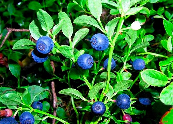
The vascular plant tussock
Among the vascular herbs, the so-called tussock has a limited distribution — a grass of the meadow-grass family that forms hemispherical hummocks up to two metres high. Associations of umbellifers are also widespread, and these plants rank among the principal peat-formers of the islands.
The peatlands of the islands
Peatlands are strongly developed on the Subantarctic islands, with peat thickness reaching up to 8 m on Macquarie Island. The development of grasses is an important defining feature of the Subantarctic, all the more so because grasses are entirely absent from Antarctica itself. Megaherbs — large-leaved flowering plants such as Stilbocarpa polaris — are characteristic of these waterlogged, nutrient-poor soils, and together with the grasses they build and maintain the deep peat profiles.
Vegetation of the Subarctic islands
The Subarctic islands are characterised by lichen–moss–meadow associations and are treeless, which is entirely natural given their low summer temperatures and strong winds. The same combination of cold and exposure that limits plants on the southern islands shapes their northern counterparts.
Auckland Island
The single exception is Auckland Island in the New Zealand sector, the warmest of the small islands of the southern temperate zone. It lies at latitude 50° 45′ S, with a coldest-month temperature of +3.3 °C and a warmest-month temperature reaching +10 °C.
The island covers 608 sq km and rises to 600 m above sea level, receiving 1,400 mm of rainfall a year. On Auckland Island, low, twisted trees still grow.

Campbell Island
Campbell Island, lying almost 2° further south (area 114 sq km, height 570 m, 52° 30′ S), is treeless, bearing only shrubs up to 1.5 m high. The Antipodes Islands, in the same sector, are likewise treeless. As a whole the New Zealand sector of the Southern Ocean, including the Macquarie Island area, is somewhat warmer than the other oceanic sectors.
This relative warmth, recognised by Cook and explained by the southward retreat of the southern continent's margin, together with the influence of Auckland Island's larger size, marks the outline of an oceanic province of the southern temperate zone.
Causes of treelessness in the temperate Southern Hemisphere
Two factors above all explain why the temperate zone of the Southern Hemisphere is so largely treeless: the inherent oceanicity of the zone, and the cooling produced by the breath of the Antarctic ice. The closer the influence of cold water and the further an island sits from a large landmass, the lower its temperatures and the fewer higher vascular plants it can support. Annual temperatures fall from about +10 °C to 0 °C along this gradient. already illustrates the scale of that ice influence.
In the southern temperate zone, features well known from the Northern Hemisphere appear in vastly exaggerated form: the partial or complete treelessness of islands and coasts exposed to the cold waters of the northern parts of the Atlantic and the Pacific Ocean is here magnified by the surrounding ocean. The chilling effect of Antarctica reinforces the pattern.
Beyond the oceanic provinces, two continental provinces must also be distinguished: the South American and the South New Zealand. The southern position of the forests of Tierra del Fuego is striking — 54° S, with Cape Horn at 55° 00′ — further south than almost all the treeless islands of the Southern Ocean (except the Balleny, South Shetland, South Orkney and South Sandwich Islands).
The richness of its flora — 440 species of higher plants — amazed the young Charles Darwin and later the Russian botanist N. M. Albov, who wrote:
The traveller approaching Tierra del Fuego for the first time will always be struck by the sight of the luxuriant forests covering this archipelago, especially in its southern and western parts… The islands of Tierra del Fuego, both in their abundant and sumptuous vegetation and in their magnificent nature, seem almost fantastical. No one would expect to find forests so green, vegetation so abundant, such elegant flowers…
These forests contain many evergreen trees: two species of southern beech (Nothofagus) and one tree of the magnolia family. The forests of the western and southern parts of the South Island of New Zealand are broadly similar in character, with canopy trees such as Metrosideros umbellata and tree ferns including Cyathea smithii. To the east of the forest belt — both on Tierra del Fuego in Patagonia and on New Zealand's South Island — steppes take over.

The same basic formations grow in the southern temperate zone as in the northern: forests, steppes and meadows all occur. Their proportions, however, differ between the hemispheres, an expression of the contrasting distribution of land and sea and thus a provincial, intra-zonal peculiarity.
Biodiversity and endemic species
The Subantarctic islands harbour exceptional biodiversity built on deep endemism, with many species found nowhere else on Earth. The New Zealand Subantarctic Islands — comprising the Snares Islands, Auckland Islands, Campbell Island, Antipodes Islands and Bounty Islands — together with Australia's Macquarie Island form one of the world's great concentrations of endemic plants, land birds, seabirds and invertebrates. The ecoregion is sometimes treated as the Antipodes Subantarctic Islands Tundra within the Australasia Realm.
The flora and fauna of this zone are remarkably archaic, and deep endemism is expressed everywhere. In the Mesozoic era, trees grew on Graham Land whose descendants survive in neighbouring Patagonia (araucaria). On Tierra del Fuego snow falls onto the surface of evergreen foliage above which hummingbirds flit, and a parrot lives on Macquarie Island.

Endemic bird species
Endemic land birds are a defining element of Subantarctic biodiversity, several confined to a single island group. The Antipodes Island parakeet occurs only on the Antipodes Islands, the Bounty Island Shag is restricted to the Bounty Platform, and the yellow-eyed penguin (Megadyptes antipodes) breeds in the southern New Zealand sector. The Snares penguin (Eudyptes robustus) nests only on the Snares Islands, and royal penguins crowd onto Macquarie Island in their hundreds of thousands. These tight ranges, the product of long isolation, make the populations both irreplaceable and vulnerable.
Albatross and seabird populations
The Subantarctic supports globally important breeding populations of albatrosses, shearwaters and petrels that give the Southern Ocean its characteristic seascape. A traveller is always struck by the great wandering albatrosses (Diomedea epomophora and relatives) that meet ships bound for Antarctica off Cape Town and accompany them to the southern edge of the temperate zone, where other petrels take over.
In January 1957 the icebreaker "Lena", on its way to Antarctica, met wandering albatrosses on the approach to Cape Town above the cold (14 °C) waters of the Benguela Current. They were very numerous down to 55° S, after which they almost vanished, and beyond 63° they disappeared entirely; near 64° the first snow petrel was sighted.

Vast colonies of the sooty shearwater (Puffinus griseus, also known as muttonbird) breed across these islands, and the seabirds collectively bind the land and sea into a single interdependent system, ferrying marine nutrients ashore where they fertilise the peatlands and megaherb fields.
Marine mammal populations
Marine mammals are among the most conspicuous wildlife of the Subantarctic, with the islands serving as critical breeding and haul-out grounds. Southern elephant seals, the largest of all seals, gather on island beaches, while the southern right whale returns to sheltered Subantarctic bays — notably around the Auckland Islands — to calve.
Elephant seals and sea lions
The "large beasts" that Novosilsky's hunters called elephant seals are the southern elephant seal (the bull weighing several tonnes), which sprawls among the tall island grasses just as the early navigators described. The New Zealand sea lion (Phocarctos hookeri) is one of the rarest sea lions in the world and breeds almost entirely within the New Zealand Subantarctic Islands, principally on the Auckland Islands and Campbell Island. Recovery of these pinniped populations after the sealing era remains a central conservation goal.
Oceanographic features of the Southern Ocean
The Southern Ocean drives the planet's largest current system and a key part of global ocean circulation, which together explain the cold, productive waters around the Subantarctic islands. The Antarctic Circumpolar Current flows unbroken around the continent through the Drake Passage, and its associated fronts — the Subantarctic Front, the Antarctic Convergence and the Subtropical Convergence — sharply separate water masses and concentrate marine life.
Antarctic Bottom Water and circulation
Antarctic Bottom Water, the densest water in the world ocean, forms near Antarctica and sinks to flow northward along the seafloor as part of the global meridional overturning circulation. This abyssal limb connects to the Global Ocean Conveyor Belt (the thermohaline circulation), whose other great sinking region lies in the North Atlantic, where deep water forms over the Greenland-Scotland Ridge. Through this conveyor the Southern Ocean redistributes heat and freshwater across the planet, regulating climate far beyond the polar latitudes.
Upwelling zones and deep-water movement
Strong upwelling around Antarctica brings nutrient-rich deep water to the surface, while downwelling carries water from the thermocline down toward the abyss, sustaining the region's high biological productivity. Abyssal geostrophic currents and intermediate water masses move along the Subantarctic Front and across the Campbell Plateau and Bounty Platform, transporting heat, salt and nutrients that ultimately feed the seabird and marine-mammal populations of the islands.
Ekman transport and eddy transfer
The persistent westerly winds drive Ekman transport, pushing surface water at right angles to the wind and forcing the upwelling and downwelling that structure the Southern Ocean. Where the mean flow cannot carry properties across the strong fronts, mesoscale eddies take over, providing the eddy transfer of heat, momentum and nutrients across the Subantarctic Front that the time-averaged circulation alone cannot accomplish.
History of the islands' exploration and use
Human contact with the Subantarctic islands has been brief, intermittent and largely destructive, leaving them among the least-modified lands on Earth. The southern position of these islands long kept them beyond regular habitation, and their human history is dominated by exploiting voyagers, shipwrecked castaways and short-lived stations rather than permanent settlement.
The European sealing and whaling era
From the late eighteenth and into the nineteenth century, European sealing and whaling gangs descended on the Subantarctic islands and devastated their seal and whale populations within decades. The same hunters whom Novosilsky watched among the elephant seals on Macquarie Island were part of this industry, which drove southern elephant seals, fur seals and the New Zealand sea lion to local collapse before the trade exhausted itself.
Cultural and historical records of settlement
The islands preserve a scattered record of attempted settlement, castaway depots, shipwreck survivors and wartime posts rather than enduring communities. Coastwatching and meteorological stations were established on several islands — including during the Second World War — and provisions depots were placed for shipwrecked sailors, while administration today falls under New Zealand's Southland region. Earlier Polynesian visits left only faint traces, underscoring how little permanent human presence these remote lands have ever sustained.
Nature conservation and protection measures
The Subantarctic islands are now among the most strictly protected places on the planet, recognised internationally for their pristine ecosystems and irreplaceable endemic life. The New Zealand Subantarctic Islands were inscribed on the UNESCO World Heritage List by the World Heritage Committee for their outstanding biodiversity and seabird colonies, and conservation bodies such as One Earth and the World Wildlife Fund highlight the ecoregion within frameworks like the Global Safety Net.
Conservation status and management categories
New Zealand's subantarctic islands hold National Nature Reserve status, the highest level of protection in the country, and are managed by the New Zealand Department of Conservation, while Macquarie Island is administered by the Tasmanian Parks and Wildlife Service. Surrounding marine reserves extend protection across the land–sea interface, and human access is tightly controlled: only limited, permit-based expeditionary tourism and research are allowed, with rigorous biosecurity to prevent the arrival of invasive species.
Efforts to conserve and protect the ecosystems
Active conservation centres on eradicating introduced pests, reintroducing native species and reducing pressures from fishing and pollution. Invasive mammals such as rats, mice, cats and pigs have devastated ground-nesting birds and native plants, and large-scale eradication programmes have already restored islands like Campbell Island. Priority actions include reducing seabird bycatch in fisheries, promoting sustainable fisheries and seafood choices, tackling plastic pollution and waste, monitoring the effects of climate change on island species, and supporting volunteer and research efforts that sustain wildlife preservation across the region.
The archaic flora and fauna of the southern temperate zone were once warmth-loving, much as in the northern temperate zone, but they retained that warm imprint better than their northern counterparts. Their character is therefore dual: young cold-loving traits combine with ancient warmth-loving ones, and it is in this very combination that the vegetation and wildlife of the Subantarctic belt hold their profound singularity. To explore more of the natural world, browse our Nature and Travel sections.