Karadag Tract in Crimea: Ancient Volcanic Massif and the Golden Gate Rock
 libre
libre
The Karadag tract is one of Crimea's outstanding natural landmarks — a Jurassic-period extinct volcano on the Black Sea coast that was declared a protected natural monument of republican significance in 1960, and reorganized as the Karadag Nature Reserve in 1979. It sits on the Crimean Peninsula between the towns of Feodosia and Sudak, and is famous for its rugged volcanic cliffs, rare flora and fauna, and the iconic Golden Gate rock arch rising from the sea.
The Karadag tract: a natural monument of Crimea
The Karadag tract, like other protected sites such as the Kholodny Yar tract and the Kremenets Mountains, ranks among the region's national natural heritage areas. The Karadag tract was proclaimed a natural monument of republican significance in 1960, recognizing both its unique geology and its exceptional biodiversity. The name Karadag (also written Kara Dag and Köktöbel in nearby place names) covers the entire mountain massif and the coastal strip around it.
The history of Karadag's protected status
Karadag's path to conservation began with science rather than tourism. The Vyazemsky Karadag Research Station was founded in 1914 by Terenty Ivanovich Vyazemsky, a physician and naturalist who built a biological station (Biostation) on the shore to study the area's land and marine life. The station later passed to the Russian Academy of Science, and the surrounding land was given monument status in 1960. In 1979 the territory was formally established as the Karadag Nature Reserve, closing most of it to unguided access in order to protect its fragile ecosystems. Today the reserve also runs the Karadag History and Nature Museum, sometimes called the Museum of Nature, which interprets the volcano's geology, minerals, and wildlife for visitors.
Geographic location and how to get there
Karadag is located on the southeastern coast of the Crimean Peninsula, between Feodosia (also spelled Feodosiya) and Sudak, within the historical region of Crimea on the northern Black Sea coast. The massif lies just west of the resort village of Koktebel and immediately above the village of Kurortnoye (also written Kurortnoe), where the reserve's administration and museum are based. Its approximate coordinates are 44.91° N, 35.22° E, with the highest point reaching 576 metres above sea level.
GPS coordinates for Karadag can be expressed in several formats for mapping and satellite navigation: decimal degrees (44.9100, 35.2200), degrees-minutes-seconds (44°54′36″N 35°13′12″E), and UTM zone 36T. Mapping services such as LatLong.net list the reserve so visitors can preview satellite imagery and plan routes before arriving.
Nearest settlements and entry points
The two main entry points to the Karadag area are the villages of Kurortnoye and Koktebel, both within the Bolshaya Feodosia (Greater Feodosia) administrative area. Reaching Karadag generally follows these options:
- From Feodosia: regular buses and minibuses run along the coast to Koktebel and Kurortnoye, a trip of roughly 30–40 minutes.
- From Sudak: coastal road transport connects to Kurortnoye from the western side.
- By car: the settlements sit just off the main coastal highway linking Feodosia and Sudak, with parking near the reserve entrance.
- By sea: boat excursions depart from Koktebel and Kurortnoye to view the cliffs and the Golden Gate from the water.
The Karadag mountain massif

The Karadag massif stretches along the Black Sea shore between Feodosia and Sudak and encompasses the entire mountain group. This is one of the oldest landscapes in the geological history of the planet. Within the single ancient Tethys Ocean, the Karadag mountain group was one of the largest centres of volcanic activity in Crimea and once formed an archipelago of islands of volcanic origin.
The present-day relief took shape considerably later — during the Neogene and Anthropogene periods, around 50–70 million years ago. It consists of a system of ancient mountain ridges: Karagach, Hoba-Tepe, Magnitny, and Kok-Kaya, which rise 200–500 metres above sea level. The most striking of these is Karadag Mount itself, whose absolute height of 576 metres above sea level makes it the dominant feature of the entire mountain landscape.
The ancient Jurassic volcano
Karadag is a rare example on the European continent of a Jurassic-period volcanic massif. The Kara-Dag Volcano erupted during the Mesozoic Era, roughly 150 million years ago, and has been extinct ever since. Its volcanic lavas are fragments of a gigantic volcanic structure, the main part of which now lies below the level of the Black Sea — a reminder that what visitors see today is only the eroded remnant of a far larger ancient volcano.
Volcanic formations and frozen lava flows
The Karadag mountains are extraordinarily picturesque thanks to their distinctive peaks, isolated crags, and steep precipitous walls that in places plunge directly into the sea. Numerous petrified lava flows and magma frozen within cracks create an unusual, otherworldly impression. The volcanic rock composition — basalts, andesites, trachytes, and tuffs dating to the Jurassic Period — records the cooling history of the massif and is one of the reasons geologists value the site so highly.

The ridges of Karadag: Karagach, Hoba-Tepe, Magnitny, Kok-Kaya
The Karadag system is built from several named ridges, each with its own character. The coastal cliffs of these ridges are deeply cut by small bays, giving the shoreline its jagged outline.
- Karagach — a seaward ridge dotted with sculpted rock figures.
- Hoba-Tepe — the highest and most rugged of the coastal ridges, with chaotic pinnacles.
- Magnitny — named for local magnetic anomalies in its rock.
- Kok-Kaya — the "blue rock," a sheer wall dropping to the sea.
Crimean Mountains geology and Karadag's place in it
Karadag belongs to the wider Crimean Mountains, the chain that runs along the southern edge of the Crimean Peninsula. Unlike the long limestone plateaus of higher summits such as Ai-Petri Mount, Karadag is volcanic in origin, which sets it apart from most of the Crimean mountain chain. Other recognisable coastal peaks like Ayu-Dag Mount share Karadag's intrusive, magmatic character, making this stretch of coast a natural museum of how the Crimean Mountains and the Black Sea basin formed together over tens of millions of years.
Coastal cliffs and shoreline relief
Curious crags are scattered along Karadag's steep precipitous walls, where the mountains meet the sea in a dramatic line of cliffs and headlands. This mountain-sea geography — high volcanic rock falling straight into the Black Sea — is what gives the reserve its reputation among Crimea's tourist attractions and among scenic viewpoints in southern Ukraine.
The Golden Gate of Karadag
The most picturesque of all Karadag's formations is the Gate of Karadag, known as the Golden Gate (Golden Gate Cliff). Through the natural arch in this offshore rock, motorboats and small craft can pass freely, which makes it the centrepiece of every sea excursion. The Golden Gate rises directly from the water and glows warm in low sunlight, a colour that gave it its name and that draws photographers throughout the year.
The Parus, Slon, and Devil's Gate rocks
Other landmark rocks rise majestically from the depths of the sea, including Parus ("Sail") and Slon ("Elephant"), each named for its silhouette. The Devil's Gate (Chertovy Vorota) is a further rocky passage tied to local mythology, part of a long tradition of Crimean Tatar and folk names attached to Karadag's strange shapes. These named rocks turn a boat trip into a tour through legend as much as geology.

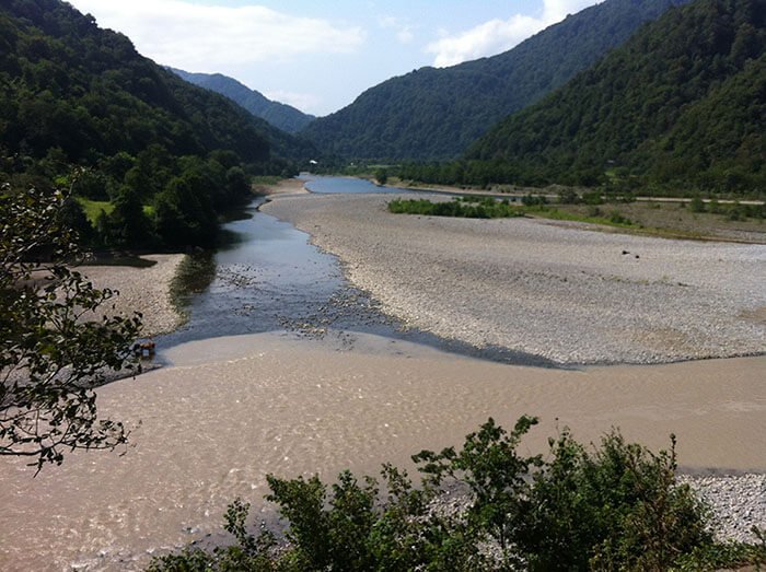
Bays and steep shores
Karadag's coastal strip is indented by numerous small bays separated by sheer headlands. The volcanic lavas exposed here are fragments of the gigantic massif whose main body lies beneath the Black Sea, and the steep, eroded walls between the bays make the shore inaccessible on foot in many places — which is exactly why the sea tour is the classic way to experience this part of the reserve.
Karadag — a natural museum of minerals
Karadag is a kind of natural museum, holding more than 100 different minerals, many of them semi-precious — carnelian, chalcedony, rock crystal, agate, jasper and others. Collectors and geologists prize these volcanic and hydrothermal stones, though under reserve rules they may not be gathered.

Semi-precious stones: carnelian, chalcedony, agate, jasper
The presence of sedimentary and marine rocks alongside the volcanic ones is evidence of later geological processes — faults, shifts, slickensides, washouts, and weathering. These same processes concentrated Karadag's famous semi-precious stones, with carnelian, chalcedony, agate, and jasper forming in the gas cavities and veins of the cooled lava.
Flora of Karadag
The diversity of Karadag's flora and fauna is explained by the unusual richness of its micro- and macro-relief and, consequently, the variety of ecological conditions, together with the location of the mountains on the boundary between the forest and steppe zones, which here combine a continental and a Mediterranean climate.
In total, more than 1,000 species of flowering and higher spore-bearing plants have been studied at Karadag.
Endemic and rare plants
Several plant species occur that are characteristic only of this locality, including Karadag wheatgrass, multicoloured skullcap, Crimean ironwort, clary sage, many-rayed seseli, Koktebel tulip, and Koktebel crambe. Karadag is also the only place where the moss Pterogonium gracile grows. Many of these rare plants are listed in the Red Data Book (Red Book) and on the European List of Endangered Species, which underpins the reserve's protection of its vegetation.
Forests and the vegetation of rocky steppes
Oak-ash woodlands cover the northern and north-western slopes of the Coastal Ridge and Karadag Mount. Coniferous forest is almost absent; only on Mount Legener (290 metres) does the tall juniper grow, with individual trees and shrubs found here and there on Karadag and very rarely along the Coastal Ridge. The vegetation of rocky steppes, cliffs, outcrops, and landslides occupies large areas, dominated by feather-grass and mixed-herb steppe communities that survive in this harsh, stony environment.

A female Pardosa tatarica (Lycosidae) on the Otuz river, Karadag
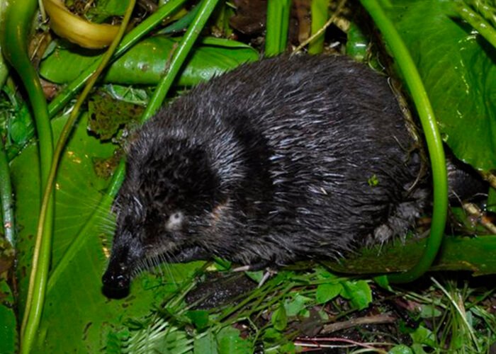
Fauna and biodiversity of Karadag
Natural conditions also shape the make-up of Karadag's animal communities. Animals that are not particularly demanding of their environment — of relief or vegetation — are found almost everywhere. These include the marsh frog, a large snake, the yellow-bellied racer (Caspian whipsnake), the chaffinch, and the fox.
Other animals are more specialised. The grey souslik, the great jerboa, and the steppe vole are found only on the steppe glades covered with feather grass and grasses; the squirrel, the imperial eagle, and the woodpecker live in the woods; the rock thrush, the white-bellied swift, and the common crag martin inhabit the cliffs of the Coastal Ridge; and the nightingale, the white wagtail, and the hedgehog are found in the gardens of the Otuz valley along the Otuz river.
Birds and ornithology of the reserve
Karadag is an important site for bird species, combining cliff-nesting, forest, and steppe habitats in a small area. Raptors such as the imperial eagle hunt over the open ground, while the rock thrush, white-bellied swift, and common crag martin breed on the precipitous coastal walls. The mosaic of forest and steppe edges supports woodpeckers, the chaffinch, and the nightingale, making the reserve a rewarding destination for ornithologists.
Marine fauna and fish of the Black Sea
The Black Sea waters within the reserve add a marine dimension to Karadag's biodiversity. The shallows and rocky shores shelter fish species typical of the northern Black Sea — gobies, mullet, horse mackerel, and others — alongside dolphins that follow the coast. This marine life was the original reason the Vyazemsky Karadag Research Station was founded, and it remains a focus of scientific study and of the reserve's dolphinarium and aquarium.
Conservation significance and management of the reserve
The Karadag Nature Reserve protects one of the few volcanic massifs in Europe together with its rare flora, cliff-nesting birds, and marine life, which is why most of its territory may be visited only on guided routes. Management is built around scientific research, education, and strict habitat protection, with rules against collecting minerals, plants, or animals. Lepidoptera and other insects are part of the monitored biodiversity, reflecting how the reserve treats even small invertebrates as indicators of ecosystem health.
Karadag's geopolitical status is contested: internationally the Crimean Peninsula is recognised as part of Ukraine (within the Autonomous Republic of Crimea), while since 2014 it has been administered by the Russian Federation. Different sources, including RIA Novosti and Ukrainian agencies, describe the reserve's jurisdiction differently. This guide refers to the natural and scientific value of the site, which remains the same regardless of political recognition.
Best time to visit and weather conditions
The best time to visit Karadag is from late spring to early autumn, when the weather is warm, the sea is calm enough for boat trips, and the trails are open. Karadag combines a continental and Mediterranean climate, so conditions vary by season:
- May–June: wildflowers in bloom, mild temperatures, and fewer crowds.
- July–August: hot and dry, ideal for sea excursions but busy; carry water and sun protection.
- September–October: warm sea, soft light for photography, and quieter trails.
- Winter: walking tours may be limited and boat trips depend on sea state and wind.
Entrance fees and booking excursions
Because Karadag is a strict nature reserve, independent hiking is not permitted, and access is organised through guided excursions that must usually be booked in advance. Visitors choose between land walking tours and sea boat trips, and group sizes are limited to protect the trails and wildlife. Tickets are arranged through the reserve administration in Kurortnoye, and advance reservation is recommended in peak season.
- Walking tour: a guided ecological trail over the ridges, typically lasting several hours, with viewpoints over the Golden Gate and the coastal cliffs.
- Sea excursion: a boat route along the shore passing the Golden Gate, Parus, Slon, and Devil's Gate rocks.
- Mixed programmes: combined land-and-sea itineraries for a fuller experience.
Confirm current entrance fees, visiting hours, seasonal availability, and group requirements directly with the reserve before your trip, as prices and schedules change.
The Karadag dolphinarium and aquarium
The Karadag dolphinarium and aquarium, run by the Biostation in Kurortnoye, are among the reserve's most popular visitor facilities. The aquarium displays Black Sea fish and other marine life from the reserve's waters, while the dolphinarium presents the research station's work with marine mammals. Both are accessible without a long hike, which makes them a practical addition to a visit.
Karadag for families with children
Karadag is family-friendly when activities are matched to children's ages and stamina. The dolphinarium, aquarium, and the Karadag History and Nature Museum offer easy, engaging visits, while the shorter guided walking routes and sea excursions suit older children who can manage uneven ground. Boat trips are often the best choice for younger families, since they show the Golden Gate and the cliffs with little physical effort.
Photography tips: equipment and settings
Karadag rewards photographers who plan around its light and its mix of cliff, sea, and sky. The Golden Gate and the coastal ridges look best in the warm hours after sunrise and before sunset, when low sunlight brings out the volcanic colours. Practical advice:
- Equipment: a wide-angle lens for the cliffs and a medium telephoto for the offshore rocks and birds; a polarising filter cuts glare on the water.
- Sea excursions: use faster shutter speeds (1/1000 s or more) to counter boat movement, and protect gear from spray.
- Landscape settings: a small aperture (f/8–f/11) keeps cliffs and foreground sharp; bracket exposures for high-contrast scenes.
- Licensing: many freely reusable Karadag images on Wikimedia Commons — including documentation from the Wiki Loves Earth 2020 project and photographs by contributors such as Sergey Malgavko and Vyacheslav Argenberg — are released under the Creative Commons Attribution 4.0 International licence, so check each file's metadata for resolution, format, and attribution requirements before reuse.
Origin of the name: Crimean Tatar and Ukrainian toponymy
The name Karadag comes from the Crimean Tatar language and means "Black Mountain" (kara = black, dağ = mountain), a description of the dark volcanic rock that distinguishes it from the pale limestone of much of the Crimean Mountains. The same massif appears in sources under several spellings — Karadag, Kara Dag, Karadag Mount, and the Kara-Dag Volcano — reflecting multilingual naming conventions across Crimean Tatar, Ukrainian, and Russian usage. Nearby Koktebel (also rendered Köktöbel) carries the same Turkic-language heritage. The Karadag tract in Crimea remains one of the most picturesque corners of nature, with its primeval flora and fauna intact.