Fluctuations of the Earth's Crust: Land Uplift, Subsidence, and Sea Level Changes
 libre
libre
The oscillations of Earth's crust are recorded by seismographs. Quite apart from these tiny movements, detectable only with precise instruments, large though very slow displacements of individual parts of Earth's surface have long been observed. These vertical shifts of the land — and the deeper mechanisms that drive them — are the subject of this article.
What are oscillations of Earth's crust?
Oscillations of Earth's crust are slow vertical and horizontal movements of the crust that raise or lower parts of the land surface over time. Some happen quickly enough to be felt as earthquakes, while most unfold over centuries and are revealed only by careful measurement against the sea or by precise surveying. They reshape coastlines, build mountains, and over geological time alter the very outlines of continents.
How are movements of Earth's crust recorded?
Movements of Earth's crust are recorded by combining instrument readings with long-term observations of fixed reference points. Two complementary approaches dominate: sensitive instruments that capture rapid motion, and repeated geodetic measurements that capture slow drift.
Seismographs and precise instruments
Seismographs register the rapid oscillations of the crust associated with earthquakes and seismic activity. They are sensitive enough to detect ground motion that no human could perceive, providing the timing and magnitude of sudden movements along faults and plate boundaries.
Levelling and sea-level observation
Slow secular movements are tracked through precise levelling — the determination of relative elevations — and through observation of sea level against fixed marks. By comparing successive surveys, geologists can measure subsidence or uplift of just centimetres per century. In parts of Germany (Bavaria, to the south and east of Munich) and in France, residents long noticed that distant landmarks such as bell towers, hilltops and other features, once clearly visible from a given spot, gradually disappeared from view, while new objects previously hidden below the horizon became plainly visible. Precise levelling here reveals slow subsidence at a rate of about 30 centimetres per century, and similar oscillations have been found to the south-west of Lake Baikal.
The structure of Earth and its crust
To understand why the crust moves, it helps to know what lies beneath it. Earth is a layered body, and the crust is only its thin, brittle outer skin riding on a hot, slowly flowing interior.
The three main layers of Earth
Earth is divided into three principal layers: the crust, the mantle, and the core. The crust is the outermost rocky shell; beneath it the mantle extends nearly halfway to the centre as hot, dense silicate rock; and at the heart lies the core, composed largely of iron and nickel. Heat escaping from the deep interior — what Mikhail Lomonosov intuitively called the heat in "the bowels of the Earth" — drives the slow churning of the mantle that ultimately moves the crust above.
Continental and oceanic crust
Earth has two distinct kinds of crust that differ in composition, thickness and density. Continental crust is thick (typically 30–50 km), relatively light, and rich in granite-type rock with a high silica content. Oceanic crust is thinner (about 5–10 km), denser, and made largely of basalt. The boundary between crust and mantle is marked by the Mohorovičić discontinuity (the "Moho"), where the speed of seismic waves changes sharply. Because continental crust is lighter, it floats higher on the mantle — the principle of isostasy — which is why continents stand above the ocean floors and why a region can slowly rise once a load (such as an ice sheet) is removed.
The lithosphere and movements of the crust
The rigid outer shell that actually breaks into moving plates is the lithosphere, which includes the crust plus the uppermost, brittle part of the mantle. Below it lies the asthenosphere, a hotter, weaker layer that deforms slowly and allows the lithosphere above to glide. The contrast in composition and strength between the cool, brittle lithosphere and the ductile asthenosphere is what makes large-scale crustal movement — and therefore the oscillations described here — physically possible.
Uplift and subsidence of the land
As early as the beginning of the 18th century it was noted that the levels of the Gulf of Bothnia and the Arctic Ocean were gradually falling, since rocks once hidden beneath the water were becoming exposed and previously unknown shoals were appearing. At first this was attributed to the drying-up of the bodies of water.
The first observations of changing sea level
The drying-up explanation fails because such changes are not seen along the whole coastline, but only in places, and to differing degrees. At some shores the sea seemed truly to be "drying up"; at others no change occurred; and elsewhere, by contrast, the sea even appeared to be "advancing", gradually flooding the former shore.
Why the "drying-up of water bodies" explanation was wrong
The real cause lies not in the "drying" or "rising" of the sea, but in the uplift and subsidence of the land, which produce seemingly opposite changes of water level within one and the same body of water. Gradually evidence accumulated about shifts of the coastline of varied character.
Marine transgression and regression
Geologists named these phenomena slow secular oscillations. The sinking of individual parts of Earth's crust caused the sea to advance onto the land — a transgression (from the Latin transgressio, "crossing over") — while uplift caused the sea to retreat — a regression (from the Latin regressio, "moving back").
Lomonosov on movements of Earth's crust
It is fitting here to cite Mikhail Lomonosov, who always anticipated his contemporaries in understanding natural phenomena:
Great change is wrought upon the Earth's surface by notable floods and deluges, which have occurred many times. The action of these is almost always joined with earthquakes, or with imperceptible, long-lasting lowering and raising of the Earth's surface. The force that lifted such a weight can be ascribed to nothing but the prevailing heat in the bowels of the Earth.
Examples of land uplift
Direct observation of sea level against specially made marks, together with the discovery of shell deposits on land (traces of an ancient sea shore), established the continuous uplift of the Scandinavian Peninsula.
The uplift of the Scandinavian Peninsula
The rise is greatest in the area of the northern part of the Gulf of Bothnia, where a total uplift of more than 200 metres has been recorded. This is a classic case of land rebounding after the heavy ice of past glaciations melted away.
Ancient terraces of South and North America
Ancient terraces were also discovered in South America, in Chile at a height of 400 metres, and in North America — Quaternary marine shells on the southern slope of Mount Saint Elias at a height of 1,500 metres. In Bolivia an even more substantial uplift of 4,000 metres is recorded. Alongside these there occurred undoubted subsidences of individual stretches of land.
Examples of land subsidence
Along the Danish and German coast of the North Sea, the remains of very ancient settlements and burial monuments are found under water.
Submerged settlements and mines
In Cornwall (England) the same fate befell ancient tin mines, now hidden under water at a depth of several metres. The submerged dwellings and workings show how far some coasts have sunk since they were inhabited.
Subsidence in the Netherlands, Belgium and Germany
Significant subsidence is also recorded in the Netherlands — about 10 centimetres per century — and especially in Belgium. The sinking of the southern shore of Lake Michigan poses a serious threat to Chicago, illustrating how human habitation is directly influenced by ongoing crustal movement.
The alternation of subsidence and uplift
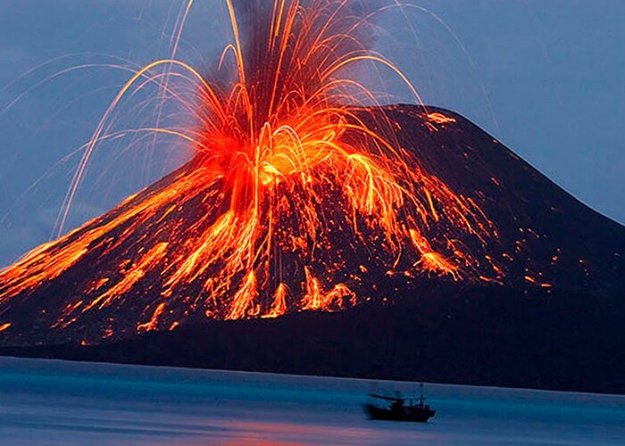
Of particular interest is the alternation of subsidence and uplift of one and the same stretch of Earth's crust. A striking example is the ruins of the ancient Temple of Serapis on the shore of the Bay of Naples in the town of Pozzuoli, near which the volcano Monte Nuovo is located (more on this: The formation of volcanoes).
The Temple of Serapis at Pozzuoli
The temple was uncovered in 1742 beneath a layer of volcanic ash. After the ash was cleared away, it turned out that the twelve-metre columns of the temple had been damaged at a height of between 3.5 and 5 metres by a rock-boring mollusc. The traces of this water-dwelling mollusc show that the locality was at one time occupied by the sea as a result of significant subsidence of the land, allowing the boring molluscs to settle on the columns.
Then the shore began to rise, and now it is sinking again — a documented full cycle of down, up and down within a single site. The study of secular oscillations of Earth's crust is of enormous importance for human economic activity. In coastal countries both uplift and subsidence pose threats: the former leads to the shallowing of harbours, obstacles to navigation and worsening fishing conditions; the latter endangers cities with flooding (Chicago), threatens farmland (the Netherlands), and imperils coastal mines and pits.
What causes oscillations of Earth's crust?
Oscillations of Earth's crust are ultimately driven by heat escaping from Earth's deep interior, which keeps the mantle slowly convecting and breaks the lithosphere into moving plates. Movements of the crust are geographically widespread and are not tied to any particular latitudes. There is an undoubted link between uplifts and subsidences: the subsidences and marine transgressions of past epochs never covered the entire surface of the globe, because equally large uplifts and regressions were occurring at the same time elsewhere.
Plate tectonics and the motion of the lithosphere
Plate tectonics is the unifying theory that explains how Earth's crust moves: the lithosphere is divided into a mosaic of rigid tectonic plates that ride on the slowly flowing asthenosphere, driven by convection currents in the mantle. Plates interact along three kinds of boundaries:
- Divergent boundaries — spreading centres such as the Mid-Atlantic Ridge, where mantle rises, melts and creates new oceanic crust through seafloor spreading; on land, rifting tears continents apart, as in the East African Rift Zone and the Central African Rift.
- Convergent boundaries — where plates collide. Where ocean meets land, subduction zones such as the Japan Trench pull oceanic crust down into the mantle, destroying it and feeding volcanic arcs; where continents collide, mountains rise, as the Himalayas are still doing.
- Transform boundaries — strike-slip faults where plates grind past one another, producing earthquakes without creating or destroying crust.
The Pacific plate, the North American plate and the small Juan de Fuca plate illustrate this system at work around the Pacific. Mountain building (orogeny) along these boundaries, balanced by erosion, continuously reshapes landforms — the Andes, for example, rise above an active subduction zone. Because uplift and subsidence are linked to where a region sits in this plate mosaic, plate tectonics ties together earthquakes, volcanic eruptions, the rock cycle and the secular oscillations described above.
Alfred Wegener's hypothesis of continental drift
The idea that continents move began with Alfred Wegener's hypothesis of continental drift, proposed in the early 20th century. Wegener gathered evidence that today's continents had once been joined in a single supercontinent he called Pangaea: the matching jigsaw fit of coastlines, identical fossils on now-separated continents, continuous mountain belts, and rock formations and ancient glacial deposits that line up only when the continents are reassembled. Wegener could not explain the driving force, so his idea was resisted for decades; the discovery of seafloor spreading and mantle convection later supplied the mechanism and vindicated him within the broader framework of plate tectonics.
Processes that form and grow Earth's crust
Earth's crust is built and rebuilt by the rock cycle, in which the three main families of rock continuously transform into one another:
- Igneous rocks form when molten rock cools and solidifies — basalt at the ocean floor, granite within continents.
- Sedimentary rocks form from compacted fragments, eroded material and the shells of organisms — like the marine shells found high on land that revealed past uplift.
- Metamorphic rocks form when existing rock is altered by heat and pressure deep in the crust, especially during mountain building.
The rock record is the primary archive geologists read to reconstruct the timeline of tectonic activity, and a mathematical "crustal growth curve" models how continental crust has accumulated through Earth's history. Researchers such as Jesse Reimink and Nathan Miller in the Department of Geosciences at Penn State, working with experimental rock-reformation studies and geochemical composition analysis, have probed the origin of primitive rock and the early planetary system; findings of this kind appear in journals including Geochemical Perspectives Letters and Terra Nova, often supported by bodies such as the National Science Foundation and the Natural Sciences and Engineering Research Council of Canada. Important data gaps remain, because the very oldest crust has largely been recycled away.
Cratons, shields and platforms
The most stable and ancient parts of the continents are the cratons — long-lived cores of continental crust that have escaped major deformation for billions of years. Where ancient crystalline rock is exposed at the surface, a craton is called a shield; where it is buried under a cover of younger sedimentary rock, it is called a platform. Cratons underlie regions like Madagascar and form the rigid hearts around which younger crust is added.
Crustal reworking processes
Crust is not only created but constantly reworked. Subduction zones destroy oceanic crust by dragging it back into the mantle, while collisions melt, fold and metamorphose existing rock into new forms. This reworking is why oceanic crust is geologically young — nowhere much older than about 200 million years — whereas the oldest continental crust survives for billions of years inside cratons. Comparing the rock record with the mineral record (for instance, durable zircon crystals that outlast their parent rock) lets geologists see further back than intact rocks alone allow.
The uniqueness of Earth's plate tectonics
Earth is, as far as we know, the only planet with active plate tectonics today, and that distinction shapes everything from its volcanism to its long-term climate. Geoscientists such as Robert Stern of the University of Texas at Dallas have argued that plate tectonics may have begun only after a long earlier period of a different, "stagnant-lid" style of crustal behaviour — a debate that frames how unusual our planet really is.
Earth's crust on other planets
Other rocky bodies have crusts, but none behave like Earth's. Venus, similar to Earth in size, has a single rigid shell with no plate boundaries, periodically resurfaced by widespread volcanism rather than recycled by subduction. Mars and Mercury have thick, immobile crusts and are tectonically dead. The Moon has an ancient crust preserved almost unchanged since early bombardment, and the lunar highlands record the planetary formation and evolution of the early Solar System. Jupiter's moon Io is the most volcanically active body known, but its activity is driven by tidal heating, not plate tectonics. Studying these extraterrestrial crusts — work involving institutions from the U.S. Geological Survey and the Smithsonian Institution to the U.S. Naval Research Laboratory — shows how exceptional Earth's mobile, self-renewing crust truly is, with clear implications for which other worlds might be geologically and biologically dynamic.
Oscillations of Earth's crust and the planet's climate
The same crustal movements that raise and lower the land also help regulate Earth's climate over geological time. As plates drift, mountain ranges rise and weather away, and volcanic eruptions vent gases into the atmosphere; together these processes govern the long-term carbon dioxide cycle. Weathering of freshly exposed rock pulls carbon dioxide out of the air, while volcanism returns it — a slow thermostat that has kept the climate broadly habitable for billions of years. Volcanic eruptions can also cool the planet sharply in the short term by injecting reflective particles high into the atmosphere.
One of the most dramatic episodes linked to this machinery is "Snowball Earth", a series of severe glaciations during the Neoproterozoic era, roughly 700 million years ago, when ice may have reached the equator. Many researchers connect these events to the breakup of a supercontinent and the resulting surge in rock weathering, which drew down carbon dioxide and tipped the climate into deep cold. This deep-time perspective also clarifies a modern question: present-day global warming is driven by human greenhouse-gas emissions acting over decades, a rate far faster than the slow natural carbon cycles that operate over millions of years — which is why human activity will not stave off a future ice age in any controlled way.
Influence on the level of the world ocean
Vertical movements of the crust directly change relative sea level along coastlines, just as the historical examples in this article show. Where the land rises, harbours grow shallow and the shoreline retreats; where it sinks, the sea floods former dry land. On a global scale, this could not fail to affect the outlines of the continents. Imagine the continent of Europe rising by 200 metres. What would happen then? Look carefully at a physical map of Europe, especially one that marks sea depths. Of the Baltic Sea only small lakes would remain, and the North Sea would vanish entirely, becoming a broad lowland.
The merged islands of Great Britain and Ireland would join the Scandinavian Peninsula in the east and the Brittany peninsula in the south. The Balkan Peninsula would close up against Asia Minor. Of the Sea of Marmara and the Aegean only small lakes would survive here and there. The Black Sea would also become a lake, and the Mediterranean would change its outline beyond recognition.
Interesting changes would await the Rhine. It would flow calmly across the northern lowland, taking in the Thames on its left and the Elbe on its right, and somewhere at the latitude of the Orkney Islands its huge delta would spread. Into the Atlantic Ocean a single mighty river would surge, with many tributaries and headwaters familiar to us — the Vistula, the Neman, the Western Dvina, and the beautiful Neva.
The older description of crustal movements by the term "secular oscillations" no longer satisfies modern science. These movements are now considered together with the formation of continents, which is why they are called epeirogenic movements, or, translated from ancient Greek, land-forming movements (from epeiros, "land", and genesis, "birth"). Epeirogenic movements are the vertical oscillations of Earth's crust — its very gentle warps and bulges that create large landforms such as basins and plains. Opposed to them are mountain-building, or orogenic, movements (from the Greek oros, "mountain").
Mountain building
The most widespread mountains are those formed by vertical and lateral movements of Earth's crust whose causes lie hidden in the planet's depths. These are tectonic mountains. Their formation is bound up with the disturbance of the original position of the crustal strata. Depending on the character of these disturbances, geologists distinguish folded mountains and block mountains (more on this: How mountains form).
The first type formed through lateral movements of Earth's crust, the second through vertical movements — that is, through the subsidence or uplift of individual sections of the crust along fractures that developed within it.
A note on access errors when reaching this page
If this article failed to load and you instead saw an access error, the message came from the web server or its content delivery network rather than from the content itself. The most common case is an HTTP 403 ("Forbidden") status code, which means the server understood your request but refused to authorize access to the resource. Many sites sit behind Cloudflare, whose security layer can block a request and return its own error page for troubleshooting.
When a block originates from Cloudflare, the error page usually shows a reference number (for example, Reference number a1325988bbcead10) together with the visitor's IP address (such as IP Address 38.180.121.36). Both are diagnostic details, not personal accusations. To resolve an "access denied" situation, the practical steps are:
- Reload the page after a short wait, in case the block was a temporary security measure.
- Disable any VPN or proxy that may have placed you on a flagged IP address.
- Clear your browser cache and cookies, then retry.
- If the problem persists, follow the site's support-contact procedure and quote the error reference number and IP address shown, so the operator can trace the event in the server logs.
These authentication-and-authorization and security-protocol mechanisms are part of normal web-server configuration; understanding the HTTP status codes and Cloudflare error codes you encounter makes troubleshooting far quicker. To keep reading instead, return to the main collection of articles on travel, nature, science and life, browse the astronomy section for related planetary topics, or use site search to find another resource.