The Destructive Power of the Sea: North Sea Storm Floods and Coastal Change
 libre
libre
The North Sea has earned the grim nickname "the killer sea" — a German poet used exactly that phrase in a poem about flooding, and the record justifies it. The destructive power of the sea is so great that it reshapes landscapes and redraws the very outlines of the land. This page traces how the North Sea, the Baltic Sea, and the world's oceans have battered coastlines through history, and adds a modern look at rogue waves, offshore storm safety, and how people defend themselves against the sea today.
The destructive power of the seas: the killer sea
The North Sea's list of crimes is so long that it would be hard to choose a fitting punishment for it. Over centuries it has swallowed villages, torn islands from the mainland, and killed tens of thousands of people in single nights. Its violence is not merely erosion at the margins — it has physically restructured the coasts of the Netherlands, Germany, and Denmark, carving new bays where dry land and freshwater lakes once lay.

The advance of the North Sea
The North Sea repeatedly overwhelmed low-lying coasts in enormous storm surges, and two of its worst assaults fell in the 14th and 17th centuries. Each time, the sea did not simply flood — it permanently altered the geography of the coastline and left the survivors to rebuild against a shifting shore.
The storm flood of 16 January 1362
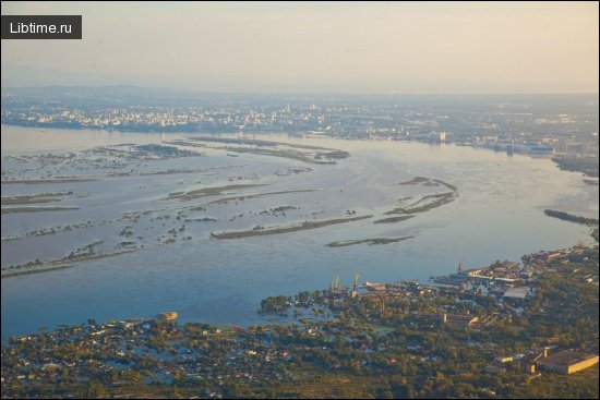
The storm flood of 16 January 1362 was probably the most catastrophic in the North Sea's recorded history. On that night the sea separated the northern Frisian Islands from the mainland and killed some 7,600 people. Much of Holland was inundated as well. Near the city of Amsterdam the rising waters turned a small lake into the broad Zuiderzee, the bay the Dutch now call the Zuider.
The bays of Jade and Dollart, on the border between the Netherlands and Germany, were formed the same way, and the raging sea devoured 44 villages there. This violent "reshaping" of nature cost human lives on a staggering scale: some 80,000 craftsmen, sailors, peasants, and townspeople paid for it with their lives.
The flood of 11 October 1634
On 11 October 1634 another storm surge struck the German coast of the North Sea and killed roughly 7,000 people. The red sandstone cliffs of the island of Heligoland resisted the assault of the storm waves with all their strength, but the sea's destructive force proved overwhelming. Ever larger stretches of land vanished beneath the water, and the patience of the coastal communities was tested to breaking point. The 1634 flood — often called the Burchardi flood — reshaped the North Frisian coast so drastically that the once-large island of Strand was broken into the fragments that survive today, including Nordstrand and Pellworm.
How the sea changes landscapes and land borders
The sea redraws coastlines by combining three forces: surge that lifts water far above normal tide levels, waves that batter and undermine soft ground, and currents that carry away the loosened sediment. Where the land is low and unprotected, a single night can turn pasture into open water and shift a national border out to sea. The Zuiderzee, the Jade Bay, and the Dollart are all monuments to this process — bodies of water that did not exist before the sea forced its way inland. Faced with this, the question for coastal people was blunt: how long could they stand by as passive spectators without answering the sea's challenge?
The human struggle against the sea: embankments, dikes, and dams
Rather than surrender ground, coastal communities decided to win back, piece by piece, the land the sea had taken. To do so they built protective embankments and dikes, and later dams. The harvests and livestock on the reclaimed ground were excellent — but that prosperity lasted only until the nordwest, the north-westerly wind, filled its cheeks again and burst through the defences.
Marshes and polders: land reclaimed from the sea
Polders are tracts of low-lying land enclosed by dikes and drained so they can be farmed, and they are the centrepiece of the Dutch answer to the sea. The word "marsh" here refers to the fertile clay flats the sea deposits and then, once diked off, the farmer keeps dry. Reclamation follows a repeating cycle:
- Build a ring dike around a shallow bay or flooded flat.
- Drain the enclosed water out — historically with windmills, later with steam and electric pumps.
- Let the exposed clay settle, leach out its salt, and become arable soil.
- Maintain the dikes constantly, because a single breach can drown the whole polder below sea level.
This ceaseless maintenance is the price of living below the waterline. The reclaimed fields fed the region generously, yet every polder existed on borrowed safety, one failed embankment away from returning to the sea.
Storm waves of the Baltic Sea
The killer sea also incited its eastern brother, the Baltic Sea, to violence. Driven by a southerly wind, the North Sea pushes its water through the Sound and the Belts into the shallow Baltic, raising it above its normal level. The water then waits for the wind to swing to the nordost, the north-easterly, and immediately surges onto the southern Baltic coast.

The All Saints' Day flood of 1809
The All Saints' Day flood of 1809 is a clear example of how the Baltic's surges are triggered by the North Sea rather than by the Baltic alone. Because the Baltic is shallow and nearly enclosed, water forced in through the Danish straits has nowhere to escape; when the wind reverses, that piled-up water crashes onto the low German coast, dividing islands and reshaping peninsulas overnight.
Storm floods of the 14th–19th centuries
Since the beginning of the 14th century, storm surges have devastated the coastal districts of the Baltic Sea about 80 times. Like an all-powerful tyrant, the sea demanded tribute again and again and received it. The disasters were not rare freak events but a recurring hazard spread across five centuries, each surge eroding cliffs, breaching embankments, and burying farmland — a rhythm of loss the coastal population learned to expect but could never fully prevent.
Marks of the water's triumph along the coast
Along the Baltic shore the signs of the water's victory are still visible today. On the island of Usedom, near the resort of Zempin, a simple board bears the inscription:
"Storm waves destroyed the village of Damerow here on 11–13 December 1873 and 9–10 February 1874."
Washed-out steep banks, breached embankments, and sand-buried fields all tell the same story of the water's triumph, reminding people of the destructive power of the seas and of the need to stay vigilant. And other seas around the globe behave just as the North Sea, the killer sea, does — not one of them is an exception.
Rogue waves: what they are
Rogue waves are exceptionally large, steep, and unexpected waves that rise far above the surrounding sea state, and they are a hazard entirely separate from storm surge along a coast. Where a surge floods the land slowly over hours, a rogue wave strikes a vessel in open water in seconds. For centuries sailors' reports of such "walls of water" were dismissed as exaggeration, until instrument records confirmed that they are real and more frequent than early oceanographers believed.
Definition and classification of rogue waves
A rogue wave is conventionally defined as a wave whose height is more than twice the significant wave height — the average of the highest third of waves in a given sea state. The British oceanographer Laurence Draper was among the first, in the 1960s, to bring scientific attention to these "freak waves" and to argue they deserved measurement rather than dismissal. Rogue waves are classified by their form and by the forces that build them:
- Constructive interference: several wave trains coincide so their crests briefly add together into one giant.
- Current focusing: waves running against a strong current are compressed and amplified, as happens off the Agulhas current along South Africa's coast.
- Wave direction and hydrodynamic forces: the steepest rogues carry enormous impact pressure on their leading face, which is what breaks structures rather than the height alone.
Modern wave measurement uses buoys, ship-borne radar, and satellite altimetry, and oceanographic research now treats rogue waves as a measurable, if still incompletely understood, phenomenon. The scientific debate has shifted from whether they exist to exactly how often they form and whether they can be forecast.
Notable encounters with rogue waves
Some of the best first-hand accounts of rogue waves come from ocean racing and single-handed sailing, where crews meet the open sea at its most extreme. In the Southern Ocean, the Tasman Sea, and the waters between Greenland and the Davis Strait, sailors have described being knocked flat or rolled by a single wave out of all proportion to the running sea. Survivor testimony from these voyages has done as much as instruments to convince the wider public that rogue waves are genuine.
- Round-the-world pioneer Robin Knox-Johnston, sailing his ketch Suhaili, was among the early single-handers to report the ferocity of Southern Ocean seas.
- Offshore racer Alex Thomson, campaigning the Hugo Boss yachts, and skippers such as Sebastien Josse, Guillermo Altadill, and Jean-François Cuzon have logged violent knockdowns in events like the Transat Jacques Vabre.
- High-latitude sailor Skip Novak and small-boat voyager Roger Taylor, aboard his tiny junk-rigged Mingming, have both written of the disproportionate danger a single wave poses to a lone sailor.
- Documentary work such as Anatomy of a Monster gathered these accounts alongside the science to trace how a monster wave forms.
Storm conditions on the open sea
Offshore storm sailing tests both the boat and the crew, because in the open sea there is no coast to run to and the biggest waves arrive without warning. Weather at sea in a gale combines sustained high wind, breaking wave crests, and confused cross-seas where waves from different directions collide — the same collisions that occasionally stack into a rogue. Understanding these conditions is the foundation of both boat handling and personal survival far from land.
Nautical safety and seamanship practices
Good seamanship in heavy weather is less about strength than about anticipation and boat management, and it centres on keeping the vessel presenting a safe angle to the waves. Yacht design and structural resilience matter here too: naval architects such as Farr Yacht Design build hulls, keels, and deck structures to survive the impact loads a breaking or rogue wave delivers, since yacht damage from a single wave — a stove-in coachroof, a lost rudder, a dismasting — is what most often ends a voyage. Core storm practices include:
- Self-steering and navigation: reliable self-steering, whether a wind vane or an autopilot, keeps the boat on a safe heading when a solo or exhausted crew cannot hand-steer for hours.
- Reducing sail early: shortening sail before the wind peaks keeps the boat controllable and reduces strain on the rig.
- Choosing a tactic: running off before the seas, heaving-to, or deploying a drogue or sea anchor, depending on the boat and the state of the sea.
- Securing everything: stowing gear below and on deck so a knockdown does not turn loose equipment into projectiles.
Personal safety measures for sailors at sea
Personal safety at sea comes down to staying attached to the boat and staying warm, dry, and rested, because a sailor washed overboard in a big sea is very hard to recover. Single-handed sailors face this challenge most acutely: if a rogue wave sweeps the deck, there is no one left aboard to turn back. Practical measures every offshore sailor relies on include:
- Wearing a lifejacket and a safety harness clipped to strong points, and rigging jackstays so the crew can move on deck without unclipping.
- Carrying an EPIRB or personal locator beacon and keeping a grab bag ready.
- Managing fatigue with short, disciplined sleep so judgement stays sharp during long storms.
- Keeping washboards in and hatches shut so a boarding wave cannot flood the interior.
Other seas of the world and their destructive power
Every ocean shares the North Sea's capacity for destruction, and the danger simply takes different forms in different waters. The Southern Ocean and the Tasman Sea are notorious for the largest, most sustained storm waves on the planet; the Agulhas current off South Africa amplifies swells into steep rogues; and the North Atlantic between the Azores, Greenland, and the Davis Strait breeds ferocious winter gales. Coastal seas drown low-lying land through surge, while open oceans threaten ships through wave impact — but the underlying force is the same restless energy of wind acting on water. Beyond seamanship, the sea's long-term behaviour is now bound up with climate change: warming oceans, driven partly by potent greenhouse gases, are already reshaping storm patterns and sea levels.
How to protect against the destructive power of the seas today
Modern defence against the sea combines hard engineering, forecasting, and long-term climate action, so that the two threats — coastal flooding and open-water storms — are each met with the right tools. Coastal protection today builds on the same principle the Dutch used with polders, but with far greater scale and precision, while offshore safety relies on technology that would have astonished earlier sailors.
- Coastal engineering: sea dikes, storm-surge barriers, beach nourishment, and managed realignment that gives water space rather than fighting every metre.
- Forecasting and warning: satellite-monitored sea states, surge models, and marine weather warnings that give both towns and ships time to react.
- Vessel design and equipment: stronger hulls, self-righting lifeboats, EPIRBs, and self-steering systems that keep a boat safe in a survival storm.
- Addressing the root cause: because global warming is raising sea levels and intensifying storms, climate change solutions include cutting greenhouse gases.
One of the most effective near-term climate strategies concerns methane, a greenhouse gas far more potent than carbon dioxide over a short horizon — roughly 80 times as powerful over 20 years — but with an atmospheric lifespan of only about a decade. That short lifespan is precisely why methane reduction offers a fast lever: cutting emissions from industrial sources such as oil and gas systems and from agricultural sources such as livestock and rice paddies can slow global warming acceleration within years rather than centuries. Methane regulatory policies now target leak detection, capture, and reduced flaring, and this mitigation timeline is short enough to blunt the very sea-level rise and storm intensification that make the seas more dangerous. Protecting coasts from the killer sea, in the long run, means protecting the climate that governs it.